Day 15, Sunday 9th August, Great sand dunes National Monument to Denver
This morning we regrouped outside the Great Sand Dunes National Monument Visitors
Centre (a National Monument is one declared by the President, whereas a National
Park is declared by Congress), Jim and Pam having left camp early to have a look at
the centre. The Great Sand Dunes were created by winds blowing toward the north east
across the San Luis Valley. Sands carried by the winds were deposited at the foot of
the high Sangre De Cristo Mountains. The dunes have been built to a height of
nearly 750 feet and cover approx. 39 square miles.
We stopped briefly along the sandy track a bit to climb a particularly high steep
part of the dunes on foot while Spielberg played cinematographer and director once
again. Little Blue performed extremely well on the sand tracks, a combination of wide
road tyres, sorry tires, light weight and adequate power made it a lot of fun in
spite of an ominous sign declaring the point of no return.
We continued on for a couple of hours on a very pleasant track through changing
vegetation, many creek crossings, and past fellow 4WD campers into the Sangre De
Cristo Mountains heading for Medano Pass. Not long after lunch Donald and Maggie
heard a noise coming from the front axle of Juanito, it sounded like a failed
bearing in the diff. Donald decided to drive in reverse for awhile as this had
worked once before. With Red in front, er, behind Juanito, well leading the way
anyway, and Blue as T.E.C. we drove the next four or five miles until Donald tried
the more conventional method of driving once again, his neck must have been getting
very strained I think, and would you believe it, no more noise. I bet I couldn't
get away with that on the Rangie.
We travelled along past Wolf Springs Ranch with its amazing sign warning would be
trespassers that they should have a lot of money, a good lawyer, or both if caught,
and onto sealed roads and into Colorado Springs, the second largest city in Colorado
, to have a quick look see and refuel before heading toward Denver. It started
raining very heavily as we left Colorado Springs. These conditions are when the
soft top is at a disadvantage, visibility, except for the windscreen, is just about
zero and unzipping side curtains takes two hands at the best of times. It makes
driving in freeway conditions in pouring rain quite a strain. We turned off the
highway during a break in the rain and stopped at the Crazy Creek Bar for drinks
and to decide whether to bush camp tonight or head back to Denver and crash on the
floor at Casa de Bushducks. Due to further threatened precipitation the latter
option was chosen.

Day 16 Monday 17 August
Amazing to wake up in a place where the walls and roof don't flap in the breeze for
the first time in a couple of weeks. After breakfast and showers all except Maggie
clean up the hired Jeeps. Maggie has arranged to take Juanito to the Jeep dealer to
have his suspect front diff seen to. A hire car is provided by the dealer and what
a stroke of luck, it's a Dodge Ram 1500 Clubcab which seats six. This means we can
all go to Buena Vista to return Blue and Red, which we do.
After a hamburger lunch in Buena Vista we turned off the highway for an alternate
route to Denver through the very trendy ski village of Breckenridge. We all had a
look at the shops, made a few purchases and before leaving happened to drive past
the Police Station, surprise, surprise, the cops here drive Discoveries, about 13 or
14 of them being on hand, quite a coup for Land Rover in the land of American iron. The police probably find that parts and accessories for the Land Rover are not as common as parts for Jeeps in this area.
Back to Denver on more of the scenic route and out to a Mexican restaurant for
dinner.
Day 17 Tuesday 18 August.
In the morning we say our goodbyes, it's been an unforgettable 16 days, with the
best of companions touring the most spectacular countryside imaginable. The Jeeps went
well, I think we missed our Range Rovers a bit, but the agile little Jeeps proved very adaptable. Roger and
Julie are flying to Idaho later today to meet with eldest daughter Amanda who will
show them Yellowstone National Park, they are undecided on accepting youngest
daughter Sally's invitation to fly to Lima, Peru and accompany her to Lake Titicaca.
Donald and Maggie have plans for next weekend in Wyoming. We fly to San Francisco,
spending five days there before hiring a car to travel down highway 1 on the coast to
Los Angeles, camping along the way, more beautiful scenery and places to see.
We have thoroughly enjoyed America and the people have been most hospitable. We would love
to come back some day.
Jim and Pam Patterson
©Days 1-5, Roger and Julie Smith 1998
©Days 6-10, Bushducks 1998
©Days 11-17, Jim and Pam Patterson 1998
Photos - © Roger and Julie Smith, Bushducks 1998
Back to Part 1
On to Part 2
 4WD Adventures: Colorado
This book lists 70 backcountry trails to help you explore the Colorado backcountry.
Read more about the book
Home
Back Country Planning
Adventure Guides
High Country Pass Status
Adventure Reports
Bushducks Land Rover
Webbed Links
Be informed when this site is updated:
 The Bushducks took the Gemini Bridges Jeep trail into Canyonlands National Park,
which included a short walk to Gemini Bridges - a large arch in a deep hole, so that
it was possible to walk over the rock bridge with staggering drops into the canyon
on either side. Then out of Canyonlands via Schafer Pass, the actual location in
"Thelma and Louise" where they take their dramatic and final plunge off what you are
supposed to think is the Grand Canyon. "Louise" was not allowed to drive at this
point, just in case! Then they followed the White Rim Trail around the cliffs over
looking the Colorado River as far as Musselman Arch. Although it was possible to
drive out on the arch, memories of London Bridge kept Juanito on solider ground.
A short detour to try out Juanito on the difficult rated "Poison Spider Mesa" Trail
to see how his coils could stretch. (Very well thank you! Nearly as good as a Range
Rover was the official verdict). They arrived back at 6pm quite sunburnt as Juanito
had inexplicably shed his doors that morning and they had gone doorless.
The Bushducks took the Gemini Bridges Jeep trail into Canyonlands National Park,
which included a short walk to Gemini Bridges - a large arch in a deep hole, so that
it was possible to walk over the rock bridge with staggering drops into the canyon
on either side. Then out of Canyonlands via Schafer Pass, the actual location in
"Thelma and Louise" where they take their dramatic and final plunge off what you are
supposed to think is the Grand Canyon. "Louise" was not allowed to drive at this
point, just in case! Then they followed the White Rim Trail around the cliffs over
looking the Colorado River as far as Musselman Arch. Although it was possible to
drive out on the arch, memories of London Bridge kept Juanito on solider ground.
A short detour to try out Juanito on the difficult rated "Poison Spider Mesa" Trail
to see how his coils could stretch. (Very well thank you! Nearly as good as a Range
Rover was the official verdict). They arrived back at 6pm quite sunburnt as Juanito
had inexplicably shed his doors that morning and they had gone doorless.
 This was supposed to take us south for 40 miles
before rejoining sealed road and the plan was to camp down at the southern end.
The trail went clearly into the wash and then became vague, with vehicle tracks
going in all directions. We split up and scouted the various dead-end canyons and
gullies, following tracks that petered out at impossible rock faces. The GPS told
us we were in the right place and pin pointed the canyon the track was supposed to
take. Pam and Jim found the proper track, but it seemed impassible. Donald scouted
on foot, whilst the rest of us stayed in various staging points communicating on the
CB's. Jim and Pam's track was the correct one, but recent flooding had washed out
the lower end of it to the point were a lot of road building would be required to get
the Jeeps through. The worst section was only a couple of hundred yards long, above
which it reverted to a well defined rocky track that climbed up and out of the ravine.
This was supposed to take us south for 40 miles
before rejoining sealed road and the plan was to camp down at the southern end.
The trail went clearly into the wash and then became vague, with vehicle tracks
going in all directions. We split up and scouted the various dead-end canyons and
gullies, following tracks that petered out at impossible rock faces. The GPS told
us we were in the right place and pin pointed the canyon the track was supposed to
take. Pam and Jim found the proper track, but it seemed impassible. Donald scouted
on foot, whilst the rest of us stayed in various staging points communicating on the
CB's. Jim and Pam's track was the correct one, but recent flooding had washed out
the lower end of it to the point were a lot of road building would be required to get
the Jeeps through. The worst section was only a couple of hundred yards long, above
which it reverted to a well defined rocky track that climbed up and out of the ravine.
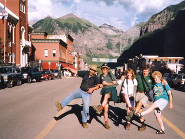 After setting up camp, we walked into town for a look at the quaint Victorian main
street. One version of the origin of the name, "Telluride", is that
when the early miners told others where they were going, they got the response,
"To hell you ride!", a reference to the difficulty of access and primitive conditions
of the early settlement. Another theory is that it is named after the mineral
Tellurium, which ironically is one of the few minerals not found here! The town,
after many years of prosperity, nearly died out by the 1960's, before someone
had the bright idea of turning it into a ski town. Nowadays, it is a vibrant, arty
and cosmopolitan town, that attracts many rich and famous people, as well as a
thriving alternative community of hippies and rastas. There are many festivals held
here, and luckily our visit was sandwiched between the Bluegrass festival and the
Chamber Music Festival. Luckily, as accommodation is next to impossible at festival
time.
After setting up camp, we walked into town for a look at the quaint Victorian main
street. One version of the origin of the name, "Telluride", is that
when the early miners told others where they were going, they got the response,
"To hell you ride!", a reference to the difficulty of access and primitive conditions
of the early settlement. Another theory is that it is named after the mineral
Tellurium, which ironically is one of the few minerals not found here! The town,
after many years of prosperity, nearly died out by the 1960's, before someone
had the bright idea of turning it into a ski town. Nowadays, it is a vibrant, arty
and cosmopolitan town, that attracts many rich and famous people, as well as a
thriving alternative community of hippies and rastas. There are many festivals held
here, and luckily our visit was sandwiched between the Bluegrass festival and the
Chamber Music Festival. Luckily, as accommodation is next to impossible at festival
time.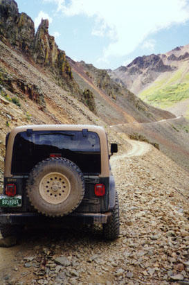 Left camp at 9.00 and headed for Ophir Pass via Ophir Loop Track and the town of
Old Ophir. It was an easy climb to the summit and yet more spectacular views - Mount
Wilson, Wilson Peak and El Diente - all over 14,000 feet. We descended the east side
for a short run along the Million Dollar Highway and turned off at Red Mountain Pass
to Black Bear Pass.
Left camp at 9.00 and headed for Ophir Pass via Ophir Loop Track and the town of
Old Ophir. It was an easy climb to the summit and yet more spectacular views - Mount
Wilson, Wilson Peak and El Diente - all over 14,000 feet. We descended the east side
for a short run along the Million Dollar Highway and turned off at Red Mountain Pass
to Black Bear Pass.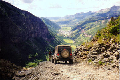 Black Bear had been called that by a bit of a wuus. However just as we started to
relax the road deteriorated dramatically and we arrived at a steep off camber "s"
bend of loose rock, dropping off steeply with nothing but Telluride way down in
the distance. We crossed Ingram Creek, which became Ingram Falls as it crossed the
track, and on to the first of the really tight switchbacks - only 13 more of these
to go. "Spielberg" was in heaven. All negotiated safely, we stopped briefly at
Bridal Veil Falls and returned to Telluride.
Black Bear had been called that by a bit of a wuus. However just as we started to
relax the road deteriorated dramatically and we arrived at a steep off camber "s"
bend of loose rock, dropping off steeply with nothing but Telluride way down in
the distance. We crossed Ingram Creek, which became Ingram Falls as it crossed the
track, and on to the first of the really tight switchbacks - only 13 more of these
to go. "Spielberg" was in heaven. All negotiated safely, we stopped briefly at
Bridal Veil Falls and returned to Telluride.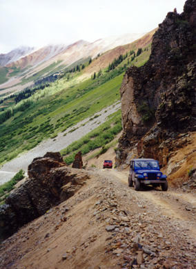 We stopped on the way to explore the ruins of Tomboy Mine. The Tomboy Mine was established in
1880 in the Savage Basin 3,000 ft. above Telluride, it prospered from the beginning
becoming one of the richest mines in North America. Originally a gold mine it also
produced silver, copper, lead and zinc. The Tomboy Mine was involved in the worst
industrial accident in North America of the time when a wagon load of hay caught
fire near the tunnel entrance. Smoke from the fire asphyxiated miners working in
the mine as well as would be rescuers. Claims that the mine management were
negligent in not having safety doors at the tunnel entrance sparked industrial
unrest that was to have far reaching implications for the future. Later in the
same year the boarding house at Tomboy was wiped out by an avalanche with many more
lives lost.
We stopped on the way to explore the ruins of Tomboy Mine. The Tomboy Mine was established in
1880 in the Savage Basin 3,000 ft. above Telluride, it prospered from the beginning
becoming one of the richest mines in North America. Originally a gold mine it also
produced silver, copper, lead and zinc. The Tomboy Mine was involved in the worst
industrial accident in North America of the time when a wagon load of hay caught
fire near the tunnel entrance. Smoke from the fire asphyxiated miners working in
the mine as well as would be rescuers. Claims that the mine management were
negligent in not having safety doors at the tunnel entrance sparked industrial
unrest that was to have far reaching implications for the future. Later in the
same year the boarding house at Tomboy was wiped out by an avalanche with many more
lives lost.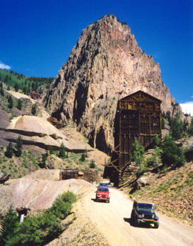 We had a brief look around and continued on to Monte Vista
and Del Norte where we stopped for fuel and supplies, and the Great Sanddunes
National Monument. The camping ground at this very popular spot was full so we
stayed at a private camping ground nearby. This was large and well equipped with
sweeping views over the Great Sanddunes and the added bonus of all the ice-cream you
could eat for $1. This brought a big smile to Roger's face as ice-cream and
fruitcake are just about his favourite foods and the latter was nowhere to be found
in America.
We had a brief look around and continued on to Monte Vista
and Del Norte where we stopped for fuel and supplies, and the Great Sanddunes
National Monument. The camping ground at this very popular spot was full so we
stayed at a private camping ground nearby. This was large and well equipped with
sweeping views over the Great Sanddunes and the added bonus of all the ice-cream you
could eat for $1. This brought a big smile to Roger's face as ice-cream and
fruitcake are just about his favourite foods and the latter was nowhere to be found
in America.