| TRAIL NAME |
NATIONAL FOREST NAME/ RANGER DISTRICT |
PHONE NUMBER |
STATUS |
DATE UPD. |
ALPINE TUNNEL
ROAD FSR 839 |
Gunnison/Gunnison |
970-641-0471 |
OPEN
Hit this trail in 2026?
Submit trail status update.
Post Up Fotos/Videos on Community FB Page.
|
5/5/26 |
COMMENTS:
|
5/5/26 - Courtesy of Silver Plume Store sharing back trail status updates once again as we enter the 2026 season.
- Alpine Tunnel Road FSR 839 is OPEN for the 2026 Season.
- Hats off to the volunteers who cleared many downed trees, and dozens of massive rocks, including some winching, off the lower and
more precarious upper trail section requiring multiple person-power, to shift all off the trail.
- Keep in mind there are still some snow patches. Dirtbikes, UTV's ATV's and well kitted out SUV's should be able to make their way up
to just shy of the parking area before the Alpine Tunnel ghost town.
- Terrific to witness the extensive 2024 repairs carried out on the Palisade rock walled section,
photo on Bushducks FB, of FSR 839
is looking great! An avalanche badly damaged the rock wall 10 years ago, see Bushducks CO Pass Page 2016 update. Being an historic site, repairs were far from
overnight easy rebuild fix.
|
|
ALTA LAKES ROAD FSR 623 |
Uncompahgre GMUG
Norwood R District |
970-874-6600
970-327-426 |
Hit this trail in 2026?
Submit trail status update.
Post Up Fotos/Videos on Community FB Page.
|
|
COMMENTS:
|
- Seasonal access dates: 5/16 - 12/31.
- Trail description at TrailDamage.
|
AMPHITHEATER ROAD
FSR 855 / CR-16
8,472 ft.
PORTLAND MINE ROAD FSR 855.1A /CR-16 |
Uncompahgre/Ouray
San Juan County |
970-240-5300 |
CLOSED
Hit this trail in 2026?
Submit trail status update.
Post Up Fotos/Videos on Community FB Page.
|
5/13/26 |
COMMENTS:
|
5/13/26 - Courtesy of Ouray County Road & Bridge.
- Amphitheatre Road FSR 855 is still CLOSED.
- Portland Mine Road is classed as OPEN for 2026. Trail surface updates at this early stage, anyone?
5/5/26 - Courtesy of Ouray County Road & Bridge.
- Amphitheater Road, paved, still under seasonal closure.
- MVUM Seasonal Opening dates non-binding:
- Amphiteatre scenic paved road, 5/15 - 9/15.
- Portland Mine Road, 4/16 - 11/30
|
ANIMAS FORKS
CR 9 /CR 2
11,160 ft. |
Uncompahgre/Ouray
San Juan County |
970-240-5300 |
OPEN
Hit this trail in 2026?
Submit trail status update.
Post Up Fotos/Videos on Community FB Page.
|
5/11/26 |
COMMENTS:
|
5/11/26 - Courtesy of long time contributor Jason H. sharing back updtaes from the trail once again.
- CR-2 from Silverton to Animas Fork is OPEN for 2026.
- One dozer is working toward California Pass on CR-9 from Animas Forks.
- Another dozer is working towards Mineral Creek on CR-17 beyond the turn-off for Engineer Pass CR-2, plowed to around 0.25 mile
at 12,70ft.
- Engineer Pass, CR-2, from the Mineral Creek CR-17 turn-off, is still closed by snow, 2 to 3 feet with bigger drits visible.
|
ARGENTINE PASS ROAD FSR 724.1
Start A. Pass Road at Waldorf Mine 11,594 ft.
A. Pass 13,207 ft. |
White River NF Dillon R District |
970-468-5400 |
OPEN **
to snow
Hit this trail in 2026?
Submit trail status update.
Post Up Fotos/Videos on Community FB Page.
|
6/8/26 |
COMMENTS:
|
6/8/26 - Courtesy of new contributor Matias D. sharing updates for 2026. Welcome aboard Matias!
** Made it up to the mines, could not make it up Argentine Pass. Blocked by snow too deep for our dirt bikes at around 12,350ft, approx
1.1 miles above the mine.
Snow blockage photos on Bushducks Facebook.
** So yes, Argentine Pass Road FSR 724.1 still blocked by snow to 4 wheelers a short distance up the trail from Waldorf Mine.
5/31/26 - Courtesy of CO Off Road Trails sharing continued updates for 2026.
** Did Leavenworth Creek Road as far as the Waldorf Mine. Headed on out Argentine Pass Road FSR 724.1 to find it's still blocked by snow
a short distance up the trail from the mine.
5/27/26 - Courtesy of CO Off Road Trails yet again for 2026.
** Ran Leavenworth Creek Road today to the Waldorf Mine. Sent up the drone to check ahead, turned back as the Argentine Pass Road
is still clearly snowed in not far past the Waldorf Mine.
5/19/26 - Courtesy of CO Off Road Trails for 2026.
** More snow again. No continuing on up. See entry 5/10/26.
5/10/26 - Courtesy of CO Off Road Trails sharing out trail status updates as ever, for 2026.
- Ran Argentine Pass Road today. Got as far as the Waldorf Mine at 11,594ft. No chance of going higher due to the trail being
clearly covered in deep snow as it winds its way on up the SE slope of Mount Edwards. A good day!
|
| ASPEN RIDGE ROAD FSR 185 / CR 175 / BASSAM PARK CR187 |
San Isabel |
719-486-0749 |
Hit this trail in 2026?
Submit trail status update.
Post Up Fotos/Videos on Community FB Page.
|
|
COMMENTS:
|
|
|
BALD MOUNTAIN TRAILS/ MT BALDY ROAD FSR 520/ 520.1/ 520.3/ 528.1b/ 528.2
Jnt Boreas PassRd CR10 10,086 ft.
Iowa Mill 11,239.
Carbonate Mine 12,127 ft.
High point Upper Mt Baldy Road 12,575 ft. |
White River/
Dillon Ranger Dist
Summit County |
970-468-5400 |
Hit this trail in 2026?
Submit trail status update.
Post Up Fotos/Videos on Community FB Page.
|
|
COMMENTS:
|
|
|
| BALDWIN LAKE/CREEK 4WD ROAD FSR 277 |
San Isabel/Salida |
719-539-3591 |
Hit this trail in 2026?
Submit trail status update.
Post Up Fotos/Videos on Community FB Page.
|
|
COMMENTS:
|
|
|
BALLARD ROAD
FSR 129 |
Canyon Lake Ranger District |
970-295-6700 |
Hit this trail in 2026?
Submit trail status update.
Post Up Fotos/Videos on Community FB Page.
|
|
COMMENTS:
|
- Ongoing comment: CLOSED until further notice, due to Cameron Peak Fires.
|
| Bangs Canyon |
BLM |
Grand Junction |
OPEN
Hit this trail in 2026?
Submit trail status update.
Post Up Fotos/Videos on Community FB Page.
|
5/7/26 |
COMMENTS:
|
5/7/26 - Courtesy of Western Slope 4 Wheelers George advocating trail-care once again, for the 2026 season.
- Neighboring trail, Tabeguache Trail Clean-Up event
proposed for May 24th by WS4W members. An opportunity to hit the trail when it opens with like-minded trail users enjoying and caring
for our trails.
- Trail-status feedback
on the clean-up is always welcomed back here at Bushducks CO PASS Page by volunteers who partake and care to share with others!
5/4/26 - Courtesy of CO ORT sharing out trail travel experiences once again, for 2026.
- Bangs Canyon tech-trail is OPEN for 2026 to those seeking a day on the rocks. Enjoy the challenge!
|
BARBOUR FORK ROAD
FSR 194.2
B Forks TH 8,490
Devils Spur T/H 10,482 ft. |
White River/Dillon
Pike/South Platte |
970-468-5400
303-275-5610 |
Hit this trail in 2026?
Submit trail status update.
Post Up Fotos/Videos on Community FB Page.
|
|
COMMENTS:
|
- REMINDER: Barbour Fork is no longer a loop trail!
|
BAXTER PASS ROAD
Garfield CR 201 |
BLM Grand Junction
|
202-208-3801 |
Hit this trail in 2026?
Submit trail status update.
Post Up Fotos/Videos on Community FB Page.
|
|
COMMENTS:
|
|
|
| Billings Canyon |
BLM |
Grand Junction |
Hit this trail in 2026?
Submit trail status update.
Post Up Fotos/Videos on Community FB Page.
|
|
COMMENTS:
|
|
|
BILLINGS LAKE/
NORTH FORK S. ARKANSAS ROAD
CR 240.
Pride of the West Mine 12,011 ft.
Angel of Shavano
Camp 9,163 ft. |
Chaffee County/
Salida Ranger Dist |
719-539-4591
719-539-3591 |
Hit this trail in 2026?
Submit trail status update.
Post Up Fotos/Videos on Community FB Page.
|
|
COMMENTS:
|
Trail Description on Traildamage.
|
BILL MOORE LAKE ROAD FSR 183.1 /
RED ELEPHANT HILL ROAD FRS 173.1A
BM Lake 11,348ft
Jnct FSR 183.1C
11,118 ft. |
Arapaho NF /
Clear Creek R Dist |
970-295-6600
303-567-4382 |
Hit this trail in 2026?
Submit trail status update.
Post Up Fotos/Videos on Community FB Page.
|
|
COMMENTS:
|
|
|
|
BIRDEYE GULCH |
Pike/South Park
Leadville County |
719-836-2031 |
OPEN
Hit this trail in 2026?
Submit trail status update.
Post Up Fotos/Videos on Community FB Page.
|
6/11/26 |
COMMENTS:
|
6/11/26 - Courtesy of regular contributor Thomas M. sharing trail updates for 2026.
- Birdseye Gulch off Mosquito Pass Lake County CR-3 is OPEN for 2026. Trail is clear and dry.
|
BLACK BEAR PASS
FSR 648 &
FSR 823
BB Pass 12,840 ft |
Uncompahgre/Ouray |
970-327-4835 |
Not OPEN Yet
Hit this trail in 2026?
Submit trail status update.
Post Up Fotos/Videos on Community FB Page.
|
5/19/26 |
COMMENTS:
|
5/19/26
- Black Bear Pass has not opened for 2026, as yet.
|
BLACKTAIL CREEK/ RADIUM ROAD
FSR 212.1 |
Routt Nat Forest
Yampa R District |
307-745-2300
970-638-4516 |
Hit this trail in 2026?
Submit trail status update.
Post Up Fotos/Videos on Community FB Page.
|
|
COMMENTS:
|
|
|
BLOWOUT PASS /
East Fork Pinos Road FR 329 /
Spring Creek Road 280 /
Pinos Creek Road FSR 14 /
Del Norte Peak Road FSR 345/
Dry Creek Road
FSR 264
B. Pass 11,774 ft. |
Rio Grande NF/
Divide Ranger Dist |
719-852-5941
719-657-3321 |
Hit this trail in 2026?
Submit trail status update.
Post Up Fotos/Videos on Community FB Page.
|
|
COMMENTS:
|
|
|
|
BOLAM PASS/ HERMOSA PARK ROAD FSR 578 |
Uncompahgre/Ouray
Columbine Ranger Dist /
Dolores Ranger Dist |
970-240-5300 |
CLOSED **
Hit this trail in 2026?
Submit trail status update.
Post Up Fotos/Videos on Community FB Page.
|
5/20/26 |
COMMENTS:
|
5/20/26 - Courtesy of San Juan County R&B and Dolores Ranger District.
** Bolam Pass is listed as CLOSED by San Juan County R&B, and OPEN per Dolores Ranger District, not gated. Trail
surface status, anyone?
- In 2005, just a few years back, Bolam Pass did not open until July 29, 2005.
- Annual tentative open and close dates: Hermosa Park Road 578: Mile 0.4 - 8.7, is 5/17 and 11/14.
- Annual tentative open and close dates: Hermosa Park Road 578: Mile 8.7 - 25.3 (Bolam Pass), is 5/17 and 11/14.
|
BOREAS PASS
Summit Co CR 10
Park County CR 33
Jnct Bald Mt Rd FSR 520 10,086ft
B. Pass 11,482 ft.
Como Cem 9,923ft |
White River/
Dillon Ranger Dist
Summit County
& Park County |
970-468-5400 |
OPEN**
Hit this trail in 2026?
Submit trail status update.
Post Up Fotos/Videos on Community FB Page.
|
5/28/26 |
COMMENTS:
|
5/28/26 - Courtesy of a new anonymous contributor and Summit County Gov update.
** Boreas Pass Road is now OPEN for 2026 on the Summit County side for summer! NOTE the Park County side remains CLOSED for maintenance,
with reopening tentatively expected by the end of May (weather permitting).
Access Reminder: This being a county road is maintained by Summit County R&B. OHVs are not permitted on this road.
|
BOULDER MOUNTAIN 4WD ROAD FSR 279
Elevation Range: 10,265 - 12,790 ft. |
San Isabel/Salida |
719-539-3591 |
Hit this trail in 2026?
Submit trail status update.
Post Up Fotos/Videos on Community FB Page.
|
|
COMMENTS:
|
|
BREAKNECK & BROWNS PASSES
FSR 175 & 176
BK Pass 10,914 ft.
Browns Pass 11,374 ft. |
Pike/Fairplay |
719-836-2031 |
Hit this trail in 2026?
Submit trail status update.
Post Up Fotos/Videos on Community FB Page.
|
|
COMMENTS:
|
|
BROWN MOUNTAIN ROAD
FSR 884 / CR 20 |
Uncompahgre/Ouray |
970-327-4835 |
OPEN**
Hit this trail in 2026?
Submit trail status update.
Post Up Fotos/Videos on Community FB Page.
|
5/6/26 |
COMMENTS:
|
5/6/26 - Courtesy of Oouray County Road & Bridge.
** Brown Mountain Road is OPEN for 2026. Bumper and Josh just finished plowing the trail. Nice work, B&J! Keep in mind, Road and
Bridge recommend you wait until Monday, May 11, before you go up Brown Mountain, as the road still needs time to melt out.
|
BULL PARK ROAD
FSR 376.A |
Pikes Peak Ranger Dist |
719-636-1602 |
Hit this trail in 2026?
Submit trail status update.
Post Up Fotos/Videos on Community FB Page.
|
|
COMMENTS:
|
|
BUNCE SCHOOL TRAIL SYSTEM
FSR 115 & FSR 105
FSR 202
IRONCLADS ROAD FSR 216.1
North Basin Road
T33 Plane Crash Site FSR 203.1 |
Boulder |
303-541-2500 |
OPEN
Hit this trail in 2026?
Submit trail status update.
Post Up Fotos/Videos on Community FB Page.
|
6/3/26 |
COMMENTS:
|
6/3/26 - Courtesy of new trail status contributor, Keith E.G. Welcome aboard, Keith!
- Bunce is OPEN and clear all the way through.
- Ironclads is completely OPEN.
- North Basin Road/
T33 Plane crash site FSR 203.1 is OPEN all the way. FSR 202, 203, 105 are classed as OPEN for 2026 by Boulder Ranger District.
- Trail is as rocky as ever. All obstacles doable. Easy with 33"s.
- MVUM seasonal open dates: weather can and does change everthing.
Bunce School trail system, 01/01 - 12/31.
North Basin Road, 6/15 - 11/15.
|
CALAMITY MESA
BLM 867/ 875/ 877 |
BLM Grand Junction |
(970) 244-3000 |
Hit this trail in 2026?
Submit trail status update.
Post Up Fotos/Videos on Community FB Page.
|
|
COMMENTS:
|
|
CALIFORNIA GULCH
CR 9.
Animas Forks Junct CR9 & CR2
10,998 ft.
Frisco Mill/ Bagley Tunnel 11,438 ft. |
Uncompahgre/Ouray |
970-240-5300 |
Hit this trail in 2026?
Submit trail status update.
Post Up Fotos/Videos on Community FB Page.
|
|
COMMENTS:
|
|
CALIFORNIA PASS
CR 19
Mountain Queen Mine 12,781 ft.
C. Pass 12,960 ft. |
Uncompahgre/Ouray
San Juan County |
970-240-5300 |
CLOSED**
to snow
Hit this trail in 2026?
Submit trail status update.
Post Up Fotos/Videos on Community FB Page.
|
6/2/26 |
COMMENTS:
|
6/2/26 - Courtesy of San Juan County R&B yet again.
** California Pass is still CLOSED. San Juan County dozers continue their progress.
5/24/26 - Courtesy of San Juan County R&B.
** California Pass remains CLOSED to snow for now. Dozer crew working their way there.
Checking previous years openings at Bushducks,
in 2024, California Pass opened on 6/14/24.
|
CARIBOU CREEK
FSR 505.1,
Rainbow Lakes CR 116J, CR 128J |
Arapho-Roosevelt/ Boulder Ranger Dist |
970-295-6600
303-541-2500 |
OPEN **
Hit this trail in 2026?
Submit trail status update.
Post Up Fotos/Videos on Community FB Page.
|
6/1/26 |
COMMENTS:
|
6/1/26 - Courtesy of Boulder Ranger District's update.
- Rainbow Lakes Road CR-116 is OPEN from today.
** Caribou Creek FSR 505 is still CLOSED for now.
- Annual anticipated Open date for Caribou is June 15 - Nov 30.
|
|
CASCADE DIVIDE ROAD FSR 579 |
San Juan / Columbine |
(970) 884-2512 |
Hit this trail in 2026?
Submit trail status update.
Post Up Fotos/Videos on Community FB Page.
|
|
COMMENTS:
|
- Annual anticipated CLOSURE date: 11/14.
|
| CEMENT CREEK ROAD FSR 740 |
Gunnison/Gunnison |
970-641-0471 |
Hit this trail in 2026?
Submit trail status update.
Post Up Fotos/Videos on Community FB Page.
|
|
COMMENTS:
|
|
| CHALK MOUNTAIN FSR 134 |
Leadville Ranger District |
719-486-0749 |
Hit this trail in 2026?
Submit trail status update.
Post Up Fotos/Videos on Community FB Page.
|
|
COMMENTS:
|
|
|
CHIHUAHUA GULCH ROAD
FSR 263
10,467 ft to 11,333 ft.
CHIHUAHUA LAKE HIKING TRAIL #78 |
White River/Dillon |
970-468-5400 |
Hit this trail in 2026?
Submit trail status update.
Post Up Fotos/Videos on Community FB Page.
|
|
COMMENTS:
|
|
|
CHINAMAN (YANSING) GULCH
BLM 6044 / CARNAGE CANYON TRAIL BLM 6043 |
San Isabel/Salida |
719-539-3591 |
OPEN
Hit this trail in 2026?
Submit trail status update.
Post Up Fotos/Videos on Community FB Page.
|
|
COMMENTS:
|
- Trail Description: See
Trail Damage for description.
|
CHINA WALL / BOX ROAD.
FSR 212 /FSR 204
Junct FSR 212 &
CR-77 8,772 ft.
China Wall crest 9,010 ft. |
Pike NF/
South Park R. Dist
Park County |
719-836-2031 |
Hit this trail in 2026?
Submit trail status update.
Post Up Fotos/Videos on Community FB Page.
|
|
COMMENTS:
|
- Seasonal Open dates - non binding: 6/16 - 12/31
|
CHINNS LAKE ROAD FSR 174.1D
RAINBOW ROAD FSR 174
Chinns Lake 11,052 ft.
Junct FSR 174 10,405 ft. |
Clear Creek R. Dist
Clear Creek County |
303-567-3000 |
OPEN **
to snow
Hit this trail in 2026?
Submit trail status update.
Post Up Fotos/Videos on Community FB Page.
|
5/31/26 |
COMMENTS:
|
5/31/26 - Courtesy of Kevin F. sharing back trail status updates for 2026.
** Chinns Lake Road FSR 174.D is partially OPEN. I got to to 11,000 feet, or .8 miles up the trail from Rainbow Road,
before it is blocked by deep snow. This
is in the shaded area after you round the switchback left-hand bend. This is a short distance, around 800 ft before Chinns Lake and
.4miles from the end of the trail near Sherwin Lake.
5/30/26 - Courtesy of CO OFT sharing out trail status as ever, for 2026.
- Rainbow Road FSR 174 is OPEN and clear of snow all the way to Fall River Reservoir.
** Chinns Lake Road FSR 174.1D is OPEN yet only for most of 3/4 mile to deep snow at 10,980ft at the switchback before you
reach Chinns Lake.
|
Cinnamon Gulch
FSR 262.1 |
White River/Dillon |
970-468-5400 |
Hit this trail in 2026?
Submit trail status update.
Post Up Fotos/Videos on Community FB Page.
|
|
COMMENTS:
|
|
|
CINNAMON PASS
San Juan CR 5
Hinsdale CR 30
Pass 12,640 ft. |
Uncompahgre/Ouray
BLM/Gunnison |
970-240-5300
970-641-0471 |
OPEN
Hit this trail in 2026?
Submit trail status update.
Post Up Fotos/Videos on Community FB Page.
|
6/1/26 |
COMMENTS:
|
6/1/26 - Courtesy of avid, long time contributor, ALT2870 sharing back trail status updates for 2026.
- Perhaps unsurprisingly for the low snow year, but Cinnamon Pass is OPEN fully for the 2026 season. Some small snow drifts
especially as you approach the summit from the east side but nothing that obstructs the trail. The summit itself has no snow at all.
Trail was in much rougher shape than when we did it last, but thinking Hinsdale County R&B is still clearing snow elsewhere before
getting started on maintenance.
- Will still need a high clearance vehicle for the east side switchbacks and the initial climb out of Animas Forks.
5/20/26 - Courtesy of San Juan County sharing out trail status updates for 2026.
** Cinnamon Pass SJ CR-5 is OPEN on the San Juan County side from Animas Forks. Awaiting status updates on the Hinsdale
County HCR-30 side, coming from Lake City.
|
CLEAR LAKE ROAD
FSR 815 /
SOUTH MINERAL ROAD FSR 585/CR7 |
Uncompahgre/Ouray
San Juan County |
970-240-5300 |
OPEN **
Hit this trail in 2026?
Submit trail status update.
Post Up Fotos/Videos on Community FB Page.
|
6/2/26 |
COMMENTS:
|
6/2/26 - Courtesy of San Juan County Road & Bridge.
** South Mineral SJ CR-7 is classed as OPEN for 2026.
- Ongoing comments: South Mineral Creek Road FSR 585 and Clear Lake Road FSR 815 are ungated.
|
CLOHESY LAKE 4WD ROAD
FSR 381
9,928 up to 10,881 ft
WINFIELD on CLEAR CREEK ROAD FSR 390 |
Leadville Ranger District |
719-486-0749 |
Hit this trail in 2026?
Submit trail status update.
Post Up Fotos/Videos on Community FB Page.
|
|
COMMENTS:
|
|
|
CONEY FLATS/CREEK ROAD
FSR 507.1
Beaver Reservoir Rd CR96 9,082 ft
Coney Flats T/H & Coney Creek crossing 9,781 ft.
Junct Middle St. Vrain Road
FSR 114.1
9,604 ft. |
Arapho-Roosevelt/ Boulder Ranger Dist |
970-295-6600
303-541-2500 |
CLOSED
Hit this trail in 2026?
Submit trail status update.
Post Up Fotos/Videos on Community FB Page.
|
6/1/26 |
COMMENTS:
|
6/1/26 - Courtesy of Boulder Ranger District sharing trail status updates once again for the 2026 season.
- Coney Flats and Middle St Vrain are still listed as CLOSED for now. Stating their Anticipated Opening Date for 2026 as June 15.
- MVUM seasonal open dates - need to check each season: Coney Flats 6/15 - 11/30.
|
COON HOLLOW
BLM Route #282
Start - Junction 282 & V2/10 north of Pyramid Rock: 5,207ft.
End 7,118ft @ top of Coon Hollow next to South Shale Ridge. |
BLM Grand Junction |
303-239-3600 |
Hit this trail in 2026?
Submit trail status update.
Post Up Fotos/Videos on Community FB Page.
|
|
COMMENTS:
|
|
|
CORKSCREW GULCH / PASS FSR 886 / Ouray County Road 20A &
San Juan CR 11 |
Uncompahgre/Ouray
BLM/Gunnison |
970-240-5300
970-641-0471 |
OPEN
Hit this trail in 2026?
Submit trail status update.
Post Up Fotos/Videos on Community FB Page.
|
6/10/26 |
COMMENTS:
|
6/10/26 - Courtesy of newcomer contributor AV rider Morgan B. sharing trail updates for 2026. Welcome aboard
Morgan!
- Corkscrew Pass is OPEN all the way for 2026, from Ouray side 550 up and over to Silverton.
- The top few switchbacks are super sketchy on large adventure bikes. There's a 12" deep water channel right down the center of
the top switchback for around 100ft and that whole section is loose dirt and golf ball size rocks. It's a vee channel with both
sides of ditch in center sloping inwards. Very traction limited. Up is better than down.
6/2/26 - Courtesy of San Juan County Road & Bridge sharing trail updates for 2026.
** Corkscrew Gulch is OPEN on the Ouray side of Corkscrew Pass. The San Juan county side of the pass SJ CR-11 is still
classed as CLOSED for now.
5/24/26 - Courtesy of San Juan Mtn Trails Group sharing out trail updates for 2026.
- Corkscrew Pass FSR 886/Ouray CR-20A is now OPEN for 2026 to San Juan CR-11.
5/13/26 - Courtesy of Ouray County Road & Bridge.
** Corkscrew Gulch Road is OPEN for 2026 from the Ironton Park side, but NOT yet open from Silverton San Juan County
side. Ouray County Rich and Bruce have completed their portion of the plow service. Nice work R&B! Expect surface conditions to vary, or close,
with the weather.
5/5/26 - Courtesy of Ouray County Road & Bridge.
- Dozer drivers Rich and Bruce are working their way up through the snow on the last of the switchbacks on Corkscrew. WTS.
- Back in 2023, Corkscrew Gulch Road opened up as a through route over the pass on June 24, 2023. Ouray County snow dozers pushing
through 40ft deep snow banks on the switchbacks
at the foot of Red Mountain #1 on May 31, 2023.
|
COTTONWOOD PASS
CR 209/CR 306
12,126 ft.
SOUTH COTTONWOOD (MINERAL BASIN) ROAD FSR 344 &
GRASSY GULCH (PTARMIGAN LAKE) ROAD FSR 349 |
San Isabel/Salida NF
Gunnison County R&B /
Chaffee County R&B |
719-539-3591
970-641-0044
719-539-4591 |
OPEN **
Hit this trail in 2026?
Submit trail status update.
Post Up Fotos/Videos on Community FB Page.
|
5/22/26 |
COMMENTS:
|
5/22/26 - Courtesy of Crested Butte Tourism updates.
** Cottonwood Pass Gunnision CR-209 / Chaffee CR-306 access route is OPEN for 2026.
- Cottonwood Pass is scheduled to Open on May 22, 2026.
|
COW CREEK
FSR 857 / CR 12
Elevation range: 7,817 - 8,431ft. |
Uncompahgre /
Ouray County |
970-240-5300 |
OPEN
Hit this trail in 2026?
Submit trail status update.
Post Up Fotos/Videos on Community FB Page.
|
5/5/26 |
COMMENTS:
|
5/5/26 - Courtesy of Ouray County R&B.
- Cow Creek Road is OPEN for 2026.
- Ongoing Notes: Cow Creek Road does not get plowed. Road ends at 8,400 ft at junction of Cow and Oben Creeks, at the start of Cow Creek Hiking Trail #220.
|
Crooked Creek
FSR 194 / 669 |
Pike/South Park |
719-836-2031 |
Hit this trail in 2026?
Submit trail status update.
Post Up Fotos/Videos on Community FB Page.
|
|
COMMENTS:
|
|
|
CUMBERLAND GULCH /
CUMBERLAND ROAD
FSR 271.1 |
Clear Creek |
303-567-3000 |
Hit this trail in 2026?
Submit trail status update.
Post Up Fotos/Videos on Community FB Page.
|
|
COMMENTS:
|
|
|
CUMBERLAND PASS FSR 765
WAUNITA PASS ROAD FSR 763
BLACK SAGE PASS FSR 887
DEPLAR PARK FSR 769
WILEY GULCH ROAD FSR 772.
C. Pass 12,021 ft.
W. Pass 10,250 ft. |
Gunnison Nat Forest
Gunnison R District
Gunnison County |
970-641-0471
970-641-0044 |
**OPEN
Hit this trail in 2026?
Submit trail status update.
Post Up Fotos/Videos on Community FB Page.
|
5/19/26 |
COMMENTS:
|
5/19/26 - Courtesy of Silver Plume Store sharing trail status updates as we roll out the 2026 season.
** Cumberland Pass is now OPEN for the 2026 season.
- Many volunteers, many shovels, plus coordination by Silver Plume means Cumberland Pass Road is OPEN the earliest in many years.
** Due to the amount of snow needing removal, the trail through is ONLY OPEN to wide UTVs at the most, at present. Make sure you have good
ground clearance to bridge the snow still in place in the middle of the trail. Enjoy and take care up there.
5/6/26 - Courtesy of Silver Plume General Store
sharing trail status updates for 2026.
- Waunita Pass Road FSR 763 is OPEN for the 2026 Season. Hats off to local volunteers have addressed the massive wind damage to
clear the trail for all vehicles.
- Wiley Gulch Road FSR 772 is OPEN for the 2026 Season. No trees down, nor snow.
5/5/26 - Courtesy of Silver Plume General Store
sharing out trail status updates yet again, for 2026.
- Cumberland Pass FSR 765 gate is OPEN for the 2026 Season. Trail surface details anyone?
- Back in 2023, Cumberland Pass opened from Pitkin as far as Halls Gulch Road FSR 766 on 5/23/23.
The trail opened to the top, 12,015ft on 6/19/23 courtesy of some volunteers with shovels.
|
CUNNINGHAM GULCH
San Juan CR 4
Highland Mary Lakes TH 10,830ft |
Uncompahgre/Ouray |
970-240-5300 |
OPEN
Hit this trail in 2026?
Submit trail status update.
Post Up Fotos/Videos on Community FB Page.
|
5/21/26 |
COMMENTS:
|
5/21/26 - Courtesy of San Juan Road & Bridge updating trail status for 2026.
- Cunningham Gulch is OPEN for 2026.
|
Dakan Mountain Road
FSR 563 |
Pike/Fairplay
South Platte Ranger Dist |
719-836-2031
303-275-5610 |
Hit this trail in 2026?
Submit trail status update.
Post Up Fotos/Videos on Community FB Page.
|
|
COMMENTS:
|
|
|
DEER CREEK /
MONTEZUMA DEER CREEK ROAD FSR 5
Junct Webster Pass Rd 10,525 ft
Teller Mountain 12,602 ft |
White River/Dillon
Park County |
970-468-5400 |
Hit this trail in 2026?
Submit trail status update.
Post Up Fotos/Videos on Community FB Page.
|
|
COMMENTS:
|
|
|
| DEMOCRAT MOUNTAIN ROAD FSR 778.1 |
Arapaho/Clear Creek |
303-567-3000 |
Hit this trail in 2026?
Submit trail status update.
Post Up Fotos/Videos on Community FB Page.
|
|
COMMENTS:
|
|
|
DEVIL'S CANYON
FSR 246
Hwy 103 9,895 ft
Devils Canyon TH 10,441 ft. |
White River/Dillon
Pike/
Clear Creek R.D. |
970-468-5400
303-567-3000 |
CLOSED
Hit this trail in 2026?
Submit trail status update.
Post Up Fotos/Videos on Community FB Page.
|
5/2/26 |
COMMENTS:
|
5/2/26 - Courtesy of CORTR Original sharing updates once again for 2026.
- Hiked the loop beyond the closed gate on Devel's Canyon FSR 246.1. Deep snow, many trees down.
- Ongoing info: MVUM open dates: 6/15 - 12/15.
|
DEXTER CREEK ROAD
FSR 871 / CR-14
8,063 up to 9,290 ft.
CUTLER CREEK ROAD FSR 872 |
Uncompahgre/Ouray
San Juan County |
970-240-5300 |
OPEN
Hit this trail in 2026?
Submit trail status update.
Post Up Fotos/Videos on Community FB Page.
|
5/5/26 |
COMMENTS:
|
5/5/26 - Courtesy of Ouray County Road & Bridge.
- Dexter Creek Road is calssed as OPEN for the 2026 season. Trail surface status, anyone?
- Adjacent Cutler Creek Road is also classed as OPEN for 2026. Again trail surface at this early stage, anyone?
- Seasonal Opening dates, non-binding: 4/16 - 11/30.
- Trail does not get plowed.
|
| Dolores Point |
BLM |
Grand Junction |
Hit this trail in 2026?
Submit trail status update.
Post Up Fotos/Videos on Community FB Page.
|
|
COMMENTS:
|
|
|
EAGLE ROCK/
LA GARITA ROAD FSR 670
CANADA ANCHO ROAD 670.2B |
Rio Grande/
Divide Ranger District |
719-657-3321
719-657-3321 |
Hit this trail in 2026?
Submit trail status update.
Post Up Fotos/Videos on Community FB Page.
|
|
COMMENTS:
|
|
|
| Eldorado Mountain |
Boulder |
303-65533;541-2500 |
Hit this trail in 2026?
Submit trail status update.
Post Up Fotos/Videos on Community FB Page.
|
|
COMMENTS:
|
|
|
ELWOOD PASS /
EAST FORK ROAD
FSR 667 &
PARK CREEK ROAD FSR 380
E Pass 11,650 ft. |
Rio Grande/Conejos
San Juan/Pagosa |
719-274-8971
970-264-2268 |
OPEN to snow
Hit this trail in 2026?
Submit trail status update.
Post Up Fotos/Videos on Community FB Page.
|
5/21/26 |
COMMENTS:
|
5/21/26 - Courtesy of San Juan Mtns TG sharing out trail status updates for 2026.
- Headed up East Fork today. Cleared trees, snoveled snow in a few places. Finally stopped shoveling and walked about 1/4 mile to the
Elwood sign through a few more sections of snow.
- Seasonal Opeening, non binding: East Fork Road FSR 667 5/15 - 11/30.
|
ENGINEER PASS
Ouray CR 18/
SJ CR 17/FSR 878/CR 2
/Hinsdale CR 20.
Lake City 8,680 ft. E. Pass 12,790 ft. Animas Forks 11,200 ft. |
Uncompahgre/Ouray
BLM/Gunnison |
970-240-5300
970-641-0471 |
OPEN **
Hit this trail in 2026?
Submit trail status update.
Post Up Fotos/Videos on Community FB Page.
|
6/1/26 |
COMMENTS: ** READ entry 4/22/26 re travel restrictions in June 2026 **
|
6/1/26 - Courtesy of regular contributor ALT2870.
- Engineer Pass Pass is fully OPEN from Animas Fork to Lake City, via San Juan CR-2, Ouray CR-2, and Hinsdale CR-20.
- The majority of this route is snow free as well. There are some muddy spots on the final push coming out of Animas Forks but just take your
time and it will be fine. The step pitch as well definitely has seen some maintenance as it is more dirt now though still have
the rocks as you breakover. Odem Point is accessible as well just dodging some snow.
- The biggest crux right now is from Odem Point to the summit. There is still snow on the shelf road. There are well defined
ruts you basically stick in and go. Nothing challenging so far. (Plus you are well away from the edge.) However as you approach
the summit on the last turn it starts breaking up and gets muddy and a touch icy. There are some ruts hidden under the slush
so it gets touch squirrelly to make you pucker for a brief second but going downhill its fine. Going uphill though I could
see this being worse especially since the mud is a touch slick. That being said, a F150 Raptor did it with some worn AT's so
maybe it doesn't seem that bad? Either way probably best just to go east bound over the pass anyway since most do it that way.
- Note in this section it is impossible to pass until Odem or the summit so make sure no one is coming first.
- The Hinsdale County side, CR-20, hasn't gotten maintained yet so expect it to be rocky and rough until you get past Capitol City.
The route up to the Golconda Boarding House is also snowed in still and appears closed with lack of signage indicating the trail.
Assuming they will clear this out soon.
5/20/26 - Courtesy of San Miguel County Road & Bridge.
** Engineer Pass SJ CR-2, San Juan County side, will be CLOSED September 14th - 18th, 2026
5/13/26 - Courtesy of Ouray County Road & Bridge.
- Engineer Pass is OPEN ** for 2026. Bumper and Josh competed their plow service.
- NOTE: The road is partially CLOSED to the public, pedestrians and cyclists included, Monday to Friday for rock removal on
the Mineral Creek section of the road within Ouray County. Anticipated completion, mid-June 2026.
5/5/26 - Courtesy of Ouray County Road & Bridge.
- Engineer Pass is still CLOSED. Ongoing plowing by Bumper and Josh at present.
4/22/26 - Courtesy of Ouray County Road & Bridge.
- Temp road closure through June. Ouray County Road & Bridge Department plans safety improvements for the Mineral Creek portion
of Engineer Pass, western section of the trail, immediately following the completion of high-country snow removal.
Dozers will deploy on April 27, and we anticipate rock grinding through most of June. While work is underway, Monday through Friday,
all traffic, to include foot traffic, will be prohibited in the affected area. The road will be open to traffic Saturdays
and Sundays.
- Yes, the lower end of Poughkeepsie Gulch is within the works restricted access area. However, the Poughkeepsie gate doesn't open
till July 1st. Fingers crossed the works go well and are completed before the official opening of Poughkeepsie.
|
EUREKA GULCH /
LAKE EMMA
San Juan CR 25 |
Uncompahgre/Ouray
San Juan County |
970-240-5300 |
CLOSED
Hit this trail in 2026?
Submit trail status update.
Post Up Fotos/Videos on Community FB Page.
|
6/2/26 |
COMMENTS:
|
6/2/26 - Courtesy of San Juan County Road & Bridge, again.
- Eureka Gulch/Lake Emma Basin is still CLOSED.
5/21/26 - Courtesy of San Juan County Road & Bridge.
- Eureka Gulch/Lake Emma basin Road SJ CR-25 is still classed as CLOSED for now.
|
| FOURMILE TRAVEL AREA, SEVENMILE CREEK ROAD FSR 311, 376, 376.B, 300 & SALT CREEK ROAD,
DEAD HORSE GULCH 4WD ROAD FSR 173 & more trails |
San Isabel/Salida |
719-486-0749
719-539-3591 |
OPEN
Hit this trail in 2026?
Submit trail status update.
Post Up Fotos/Videos on Community FB Page.
|
5/1/26 |
COMMENTS:
|
- Seasonal Comment: Fourmile Travel Area gates OPEN for north and south areas are mostly May 1st. Dead Horse Gulch 4WD
Road FSR 173 seasonal gate opens April 15th.
|
GARIBALDI GULCH ROAD
FSR 356.1
Junct FSR 354.1 10,552 ft.
Wise Mt. Cabin 12,054 ft.
Junct FSR 275.1 12,517 ft. |
White River/Dillon |
970-468-5400 |
Hit this trail in 2026?
Submit trail status update.
Post Up Fotos/Videos on Community FB Page.
|
|
COMMENTS:
|
- Ongoing Comment: The cabin out on the short spur up to the top of Wise Mountain dates back to 1878 and was used by the Wise Mountain Silver Mining claim. It overlooked the mining settlement of
Swandyke in the Middle Fork Swan River valley below to the east - long gone, yet one cabin is hanging in there.
Cabin photo on Bushducks FB.
|
GENEVA CREEK ROAD (UPPER)
FSR 119
Geneva Rd 9,722 ft.
Sill Mine 11,808 ft. |
White River/Dillon
Pike/South Platte
Park County &
Clear Creek Co.
|
970-468-5400
303-275-5610 |
OPEN
Hit this trail in 2026?
Submit trail status update.
Post Up Fotos/Videos on Community FB Page.
|
5/24/26 |
COMMENTS:
|
5/24/26 - Courtesy of CO ORT sharing out updates and South Platte Ranger District
- Geneva Creek gates are OPEN for 2026. Deep snow at the upper end of the trail.
Seasonal Opening dates, non binding: 5/16 - 12/31
|
GEORGIA PASS
South Fork Swan FSR 355 /
Michigan Creek Road CR-54
GLACIER RIDGE ROAD
FSR 258.1
Mt Guyot Loop East
G Pass 11,585 ft. |
White River/Dillon |
970-468-5400 |
OPEN **
Hit this trail in 2026?
Submit trail status update.
Post Up Fotos/Videos on Community FB Page.
|
6/13/26 |
COMMENTS:
|
6/13/26 - Courtesy of newcomer trail contributor wishing to remain anonymous on their first update, assisted
by Dillon Ranger District update. Welcome aboard newcomer!
** Glacier Ridge Road FSR 258.1 remains CLOSED for now. This is indicated by the Dillon Ranger District.
- Where the northern end of Glacier Ridge Road meets Middle Fork Swan FSR #6.2, there are several large downed trees blocking the
entrance to the trail.
- Not sure how far you can go from the Georgia Pass end, the southern end of Glacier Ridge Road.
- Additional update anyone?
5/21/26 - Courtesy of Dillon Ranger District sharing trail status updates for 2026.
** Georgia Pass South Fork Swan FSR 355, Breckenridge side of the pass is OPEN. Road surface status anyone?
5/16/26 - Courtesy of CO Off-Road Trails sharing out trail status updates yet again for 2026.
- Georgia Pass Road FSR 355.1 is still CLOSED for now on the Breckenridge side.
-MVUM Seasonal OPEN dates, non-binding:
Summit County side South Fork Swan: 05/21 - 11/22.
Park County side Michigan Creek: 01/01 - 12/31
|
| Gold Hill/Boulder CR 93/ Switzerland Trail north end FSR 120J.0 |
Boulder | 303-541-2500 |
OPEN
Hit this trail in 2026?
Submit trail status update.
Post Up Fotos/Videos on Community FB Page.
|
5/19/26 |
COMMENTS:
|
5/19/26 - Courtesy of CO ORT sharing updates for 2026.
- Enjoyed the trail today.
- Seasonal opening dates, non-binding: 01/01 - 12/31.
|
GOOSE CREEK /MATUKAT ROAD
CR-211 |
Pike/Fairplay |
719-836-2031 |
OPEN
Hit this trail in 2026?
Submit trail status update.
Post Up Fotos/Videos on Community FB Page.
|
5/11/26 |
COMMENTS:
|
5/11/26 - Courtesy of CO OFF Road Trail sharing out trail status updates once again for 2026.
- Cool easy trail west of Cheeseman Reservoir.
|
|
GORDON GULCH ROAD FSR 233.1 |
Roosevelt National Forest |
970-498-1100 |
Hit this trail in 2026?
Submit trail status update.
Post Up Fotos/Videos on Community FB Page.
|
|
COMMENTS:
|
|
|
GOVERNOR BASIN FSR 853.1C/ Ouray CR-26a /
SILVER BASIN ROAD FSR 869.3A
|
Uncompahgre/Ouray |
970-240-5300
970 |
In Progress**
Hit this trail in 2026?
Submit trail status update.
Post Up Fotos/Videos on Community FB Page.
|
5/13/26 |
COMMENTS:
|
5/13/26 - Courtesy of Ouray County Road & Bridge, yet again.
- ** Snow removal is still underway on Governor Basin Road for EPA work - see access info 5/6/26.
5/6/26 - Courtesy of Ouray County Road & Bridge.
** Snow removal is in progress on Governor Basin Road so that EPA work may be done. A "ROAD CLOSED" sign will be in place at
the last place suitable to turn around on the road.
5/5/26 - Courtesy of Ouray County Road & Bridge.
** Silver Basin FSR 869.3A classed as OPEN for 2026, still has snow to the bottom. Additional trail melt conditions, anyone?
- Back in 2023, Governor Basin Road was almost open to the top at just over 12,000ft on August 7, 2023. A deep snow drift
blocked the last section near the end of the trail leading on to
Mountain Top Mine.
|
| Granite Creek Canyon |
BLM |
|
Hit this trail in 2026?
Submit trail status update.
Post Up Fotos/Videos on Community FB Page.
|
|
COMMENTS:
|
|
|
GREEN RIDGE ROAD
FSR 319
GREEN RIDGE CUTOFF ROAD FSR 177.
From Lost Lake
CR 103 to CR 86 |
Araphoe Roosevelt/
Canyon Lakes R Dist
Larimer County |
970-498-1100
970-295-6700
970-498-5650 |
Hit this trail in 2026?
Submit trail status update.
Post Up Fotos/Videos on Community FB Page.
|
|
COMMENTS:
|
- Ongoing Comment:
- Green Ridge Road FSR 319 Anticipated open/close dates: 6/15 - 11/30.
- Green Road Cutoff Road FSR 177 Tentative open/close dates: 7/1 - 11/30.
|
GREER ROAD
FSR 154 |
Roosevelt National Forest |
970-498-1100 |
Hit this trail in 2026?
Submit trail status update.
Post Up Fotos/Videos on Community FB Page.
|
|
COMMENTS:
|
- Historic, 2025, note re access issues: Courtesy of Canyon Lakes Ranger District.
** Open to motorcycles and e-bikes ONLY due to Ballard Road closure. Only accessible from Danner Pass trail. May
be impassable in winter and spring months.
|
GRIZZLY LAKE /
GRIZZLY GULCH 4WD Road FSR 296 |
San Isabel/Salida |
719-539-3591
|
OPEN
Hit this trail in 2026?
Submit trail status update.
Post Up Fotos/Videos on Community FB Page.
|
5/11/26 |
COMMENTS:
|
5/11/26 - Courtesy of CORE
sharing back updates from the trail, as ever!
- Grizzly Lake/Gulch 4WD Road FSR 296 is OPEN for 2026 right up to the lake. Expect snow on the road.
- Back in 2023, Grizzly Lake was open to travel the full length up to the lake at 11,210ft on July 6th, 2023.
|
GUANELLA PASS ROAD
CR 62 / FSR 381
Duck Lake 11,112ft
G. Pass 11,669 ft. |
White River/Dillon
Pike/South Platte.
Clear Creek County
Park County |
970-468-5400
303-275-5610 |
OPEN
Hit this trail in 2026?
Submit trail status update.
Post Up Fotos/Videos on Community FB Page.
|
5/18/26 |
COMMENTS:
|
5/18/26 - Courtesy of regular trail status contributor Thomas M., yet again.
- Guanella Pass is OPEN and clear all the way.
5/16/26 - Courtesy of Clear Creek County Road and Bridge.
- NOTICE: GUANELLA PASS OPENING EARLY FOR SUMMER 2026
Thanks to a coordinated effort between Clear Creek County R&B, Park County R&B, and the USFS, Guanella Pass will officially open early
for the summer season at 9:00 a.m. on Thursday, April 16th.
- Due to unseasonably low snow levels, crews were able to clear the route significantly earlier than the typical Memorial Day Weekend
opening, providing residents and visitors with early access to the Scenic Byway.
- While conditions currently allow for travel, visitors should be aware that the pass remains subject to temporary closures if spring
snowstorms create hazardous driving conditions.
Seasonal access dates, non-binding: 5/25 to 11/15
|
GUNSIGHT PASS
FSR 585 |
White River/Sopris District |
970-963-2266 |
Hit this trail in 2026?
Submit trail status update.
Post Up Fotos/Videos on Community FB Page.
|
|
COMMENTS:
|
|
|
HACKETT GULCH
FSR 220
High Pt 8,890 ft. |
Pike National Forest
South Platte Ranger District |
303-275-5610 |
OPEN
Hit this trail in 2026?
Submit trail status update.
Post Up Fotos/Videos on Community FB Page.
|
5/9/26 |
COMMENTS:
|
5/9/26 - Courtesy of our new trail status contributor for 2026, Glenn H. Welcome aboard Glenn.
- Hackett Gulch Road FSR 220 is OPEN for 2026. Road is dry.
- Ongoing Comment: Know before we go, know the travel boundaries on trails, this one included. Checking the MVUM is a responsibility we all share.
|
HAGERMAN PASS
FSR 105 / FRYING PAN ROAD FSR 105.1
Lake I. 10,909 ft
H. Pass 11,925 ft
Carlton Tunnel east portal 10,795
Turquoise Lake
9,869 ft. |
San Isabel/Leadville
White River/Sopris |
719-486-0749
970-963-2266 |
OPEN
Hit this trail in 2026?
Submit trail status update.
Post Up Fotos/Videos on Community FB Page.
|
6/7/26 |
COMMENTS:
|
6/7/26 - Courtesy of long time contributor Jerry Y. hitting the trails for 2026.
- Hagerman Pass is OPEN for the 2026 season from Basalt to Leadville. No issues to report.
- MVUM seasonal open dates:
Frying Pan Road, 5/21 - 11/ 22.
|
HALFMOON CREEK/GULCH ROAD
FSR 110 |
San Isabel/Leadville
White River/Sopris |
719-486-0749
970-963-2266 |
OPEN
Hit this trail in 2026?
Submit trail status update.
Post Up Fotos/Videos on Community FB Page.
|
4/19/26 |
COMMENTS:
|
4/19/26 - Courtesy of CORE hitting the trails and sharing back once again for the 2026 season.
See Core's Video.
- Halfmoon Road FSR 110 is OPEN and clear to travel up to North Halfmoon Lakes #1485 hiking trailhead at 10,540 ft. FSR 110 has minimal
water over the trail as you cross Halfmoon Creek at this point. Small snow patches kick in under the trees, as we continue above the
10,700 feet level. Some vehicle has turned around seemingly due to larger stretches of deeper snow as the trail opens out near the beaver
lakes at around 11,060 ft, just above the next crossing of Halfmoon Creek, that's 1.1 mile above North Halfmoon Lakes trailhead.
- We dropped some air, and continued on through deeper sections of snow for a short distance to our first downed, large tree. Chainsaws
out, all clear on we go to a few more smaller trees down, before crossing the site of an avalanche clearing of 2019 by CORE. Snow patches
increasing in length in this open section as we move above 11,250ft.
- Cleared a lot of windblown uprooted trees at 11,500ft so we can stay the trail which has good mounds of snow to negotiate. Crawled on
through some off campber snow sections to finally reach the Champion Mill trail on our right, before crossing the low flowing creek
once again to then exit over a rise and snow mound. Slow crawling through deeper snow to finally turn around due to off camber deep
snow section directly across the valley from Champion Mill at 11,240ft, some 4 miles above the North Halfmoon Lakes trailhead. That's
us for today. Time for lunch and head on back down.
- Ongoing info: Halfmoon Road FSR 110 and South Halfmoon 4WD Road FSR 110J do not have a seasonal closure. Both are OPEN to all vehicles, yearlong, conditions allowing.
- Remember, don't drive around snow drifts. If you can't push thru on the trail proper, turn around and come back another day
when the snow has melted to enjoy the trail without damaging the surrounding terrain.
|
HALLS GULCH ROAD FSR 766
10,021 to 11,092 ft |
Gunnison NF/ Gunnison County
Gunnison Ranger District |
970-641-0471
970-641-0471 |
Hit this trail in 2026?
Submit trail status update.
Post Up Fotos/Videos on Community FB Page.
|
|
COMMENTS:
|
|
|
HANCOCK LAKE ROAD FSR 295
9,984 to 11,655 ft |
San Isabel NF/Salida |
719-539-3591 |
OPEN
Hit this trail in 2026?
Submit trail status update.
Post Up Fotos/Videos on Community FB Page.
|
6/4/26 |
COMMENTS:
|
6/4/26 - Courtesy of CORE,
sharing trail status updates.
- Hancock Lake Road FSR 295 is now fully OPEN to the lake.
5/11/26 - Courtesy of CORE,
promoting reponsible trail etiquette plus trail status updates.
** Hancock Lake Road FSR 295 is OPEN for 2026 to just 1.2 miles in (above the turn-off for Hancock Pass Road FSR 299) to around 11,500ft.
Expect deep snow on the trail, if you decide to go. Rembering to travel with an equally well-prepared buddy vehicle. Lone vehicle
travel in conditions such as this, is gambling with our lives, and those who may have to come rescue us.
- MVUM Seasonal access dates: 01/01 - 12/31. Keep in mind, trail closes whenever mother nature chooses.
|
HANCOCK PASS JEEP TRAIL FSR 299 & FSR 266
|
San Isabel/Salida
Gunnison County /
Chaffee County |
719-539-3591
970-641-0471 |
OPEN **
Hit this trail in 2026?
Submit trail status update.
Post Up Fotos/Videos on Community FB Page.
|
6/3/26 |
COMMENTS:
|
6/3/26 - Courtesy of CORE yet again!
** Hancock Pass Road FSR 299 is OPEN on the St Elmo side of the pass, up close to the pass, but NOT over the top.
5/30/26 - Courtesy of CORE once again.
- Typical for end of May snow is still too deep on the north side of the pass, the St Elmo side, Hancock Pass Road FSR 299.
- CORE has politely dropped the gauntlet on a dig out when responding to the status of the trail. Tempted? Got a snow shovel that needs
exercise? Go see CORE
and consider joining one of their manual group volunteer fun dig days. Go Dig Me!
Close to his time last year, June 11, 2025, Hancock Pass Road FSR 299 was open to around 11,680 ft,
Hancock snow photo on Bushducks FB 2025.
5/11/26 - Courtesy of CORE sharing back trail status updates as ever.
** Hancock Pass Road FSR 299 is OPEN for 2026 for most of 1.3 miles above the old town of Hancock, to around 11,630ft with deep snow
on the trail. Be prepared and lets not travel in a lone vehicle in these conditions.
- REMINDER: Check before you go! OHV permits required by all vehicles on this trail. See list of trails requiring such
permits at https://staythetrail.org/full-size-trails/
- Additional Reminder: In 2023, Hancock Pass Road was designated as Hancock Pass Jeep Trail #9266, making it the same name as section
over the west side of the pass. This trail requires an OHV permit for ALL street legal vehicles. Be sure to PAY & DISPALY Details:
https://staythetrail.org/full-size-trails/ and yes, enjoy :)
|
HANDCART GULCH ROAD
FSR 121
W Pass 12,099 ft. |
White River/Dillon
Pike/South Platte |
970-468-5400
303-275-5610 |
Hit this trail in 2026?
Submit trail status update.
Post Up Fotos/Videos on Community FB Page.
|
|
COMMENTS:
|
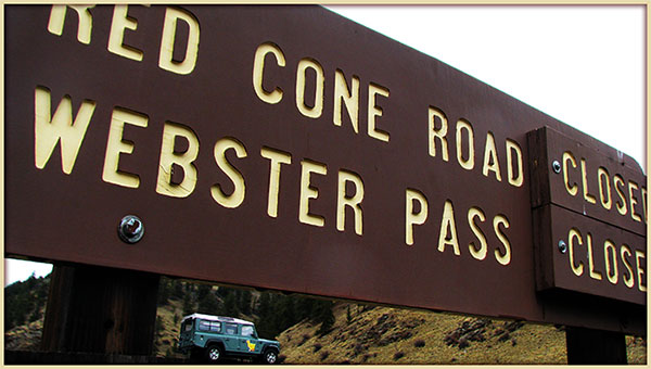
- ONGOING REMINDER: No access up Red Cone Road FSR 565 from Webster Pass. One-way travel only, in the downward direction from Red Cone
summit toward Webster Pass.
- In 2022, Hancart Gulch OPENED on July 7th.
- Wonder why it takes so long for mother nature to open up Handcart Gulch - Webster Pass Road?
Check out
snow drift foto of Handcart side of Webster Pass taken July 6th, 2022.
|
HAYDEN PASS
FSR 970/
Hayden Creek Rd Fremont CR 6
Hayden Pass: 10,745ft |
Rio Grande/Saguache
San Isabel/Salida |
719-655-2547
719-539-3591 |
**OPEN to snow
Hit this trail in 2026?
Submit trail status update.
Post Up Fotos/Videos on Community FB Page.
|
5/7/26 |
COMMENTS:
|
5/7/26 - Courtesy of a new contributor preferring to stay anonymous at this initial stage of sharing. All good,
welcome aboard!
- Hayden Pass is OPEN ** for 2026.
** Trail is NOT open all the way through. I went in on Hayden Pass Road FSR 970 from Villa Grove, encountered snow drifts about 1 mile east of Hayden Pass at
10,200 ft. Reminder, this side of the pass, east side, is Hayden Creek Road/Fremont CR-6.
|
|
HEART LAKE ROAD FSR 518.1B & CARSON ROAD/SADDLE FSR 518 & 568 |
Rio Grande
Divide |
719-655-2547 |
Hit this trail in 2026?
Submit trail status update.
Post Up Fotos/Videos on Community FB Page.
|
|
COMMENTS:
|
|
|
HERMIT PASS/ LAKE ROAD FSR 160
Start 8,630 ft
H. Pass 13,061 ft |
Rio Grande/Saguache
San Isabel/San Carlos |
719-655-2547
719-269-8500 |
OPEN**
Hit this trail in 2026?
Submit trail status update.
Post Up Fotos/Videos on Community FB Page.
|
5/26/26 |
COMMENTS:
|
5/26/26 - Courtesy of CO-ORT sharing out trail updates for 2026.
** Travelled up Hermit Lake Road FSR 160 today without issue to 11,360ft to access Hermit Lake. A few weeks back I had attempted to go
further up FSR 160, but still couldn't reach Horseshoe Lake overview. The trail could still be snowed in, as it's most of 3 miles
to the pass from the Hermit Lake Hiking Trail #1353 with an elevation gain of 1,670ft.
- Seasonal opening dates: 01/01 - 12/31.
|
| Hidden Valley Trail |
Pike/South Platte |
303-275-5610 |
Hit this trail in 2026?
Submit trail status update.
Post Up Fotos/Videos on Community FB Page.
|
|
COMMENTS:
|
|
|
HOLY CROSS CITY FSR 759.1
Start 9,360 ft
End 11,450 ft. |
San Isabel/Holy Cross |
970-827-5715 |
OPEN**
Hit this trail in 2026?
Submit trail status update.
Post Up Fotos/Videos on Community FB Page.
|
5/21/26 |
COMMENTS:
|
5/21/ 26 - Courtesy of CORE
out checking trails and sharing back status updates for 2026.
** Holy Cross City Road is OPEN for 2026. Trail is clear of all snow up the initial one way, upward section, as far as the exit route,
Fancy-French Road. There's been a few fallen trees cut and removed off the trail around there. Nice work by those who came up before us
in the last couple of days.
- Reached the gatekeeper dip and short rock climb obstacle, where one tree has been cut and cleared. Two other leaning trees are
almost ready to fall across the track there, so we cut and cleared a few. Still no snow on the ground to date, with this year's low
snow level almost matching the low level of 2013.
We continued as the trail becomes more challening in the short rock climbs, Steep
Rock included where rear steer vehicles excell, but still no snow until shortly before French Creek crossing at 11,00 ft.
Last Chance water bar and exit channel on the lower edge of French Creek, a rock arrangement CORE instsalled with the aid of machinery
back in 2024 is holding well and helps to deflect the creek course off the track creating less chance for water contamination, before
entering the rock obstacle proper when crossing the creek at around 11,200 ft.
Snow is still banked up as we hit the sideways slant climb away from the main part of French Creek. Trees down across the trail ahead.
Time to call it a day at just over 11,200ft. Time to turn around before our day becomes too short for a safe trip back down the trail
with some additional maintenance work to be done on the way.
- Seasonal Access Dates, non binding: 5/21 - 11/22.
- Trail Description on
TrailDamage.
|
HOMESTAKE ROAD FSR 703.1
8,791 TO 10,085 ft. |
White River /
Eagle-Holy Cross |
970-945-2521
970-827-5715 |
OPEN
Hit this trail in 2026?
Submit trail status update.
Post Up Fotos/Videos on Community FB Page.
|
5/18/26 |
COMMENTS:
|
5/18/26 - Courtesy of CORE checking on trails for 2026.
- Homestake gate is OPEN for 2026. That's a few days ahead of the expected date, due to the lesser amount of snow this year.
- We headed on up and checked out access to Holy Cross City Road which commences at 9,325ft. Homestake is clear to here.
Seasonal access dates, non binding: 5/21 - 11/22.
|
HURRICANE PASS San Juan CR 10
12,730 ft. |
Uncompahgre/Ouray |
970-240-5300 |
CLOSED **
to snow
Hit this trail in 2026?
Submit trail status update.
Post Up Fotos/Videos on Community FB Page.
|
6/2/26 |
COMMENTS:
|
6/2/26 - Courtesy of San Juan County Road & Bridge sharing updates for 2026.
** Hurricane Pass is still CLOSED to snow.
San Juan CR-11 is also still classed as CLOSED for now.
5/24/26 - Courtesy of San Juan Mtn Trail Group sharing out updates for 2026.
** Hurricane Pass remains CLOSED to snow for now.
- San Juan CR-10 is OPEN for travel to, but classed as still CLOSED for travel via SJ CR-11 to Corkscrew Pass to connect to SFR 886.
|
IMOGENE PASS
CR K68/
FSR #869/CR 26A
Telluride 8,875 ft
I PASS 13,114 ft
Junct I Pass Rd & CR26A 11,242 ft. |
Uncompahgre/Ouray |
970-327-4835 |
OPEN **
to snow
Hit this trail in 2026?
Submit trail status update.
Post Up Fotos/Videos on Community FB Page.
|
6/4/26 |
COMMENTS:
|
6/4/36 - Courtesy of San Miguel County Road and Bridge updating all for the 2026 season.
** County Road K68 (Tomboy Road) is NOW OPEN for 2026 from the Town of Telluride to the historic Tomboy townsite. Please contact the
Town of Telluride for information regarding road construction impacts on the lower section of the road.
6/3/36 - Courtesy of San Juan Trails Groupl sharing around trail updates yet again.
- Made it 4 miles up FSR 869 from Camp Bird Road toward Imogene Pass from the Ouray side to 12,345ft, map,
to the flase summit. As posted in the
last entry below this, you can clearly see Ouray County Rich and Bruce's dozer tracks that continue on up to Imogene Pass, some
1.25 miles and a further climb of 850ft. Quite some trail cleanup to happen by R&B before you can travel further than today's location.
Enjoy the anticipation, and the awesome journey back down.
6/3/36 - Courtesy of Ouray County Road and Bridge yet again.
** Get Excited! Ouray dozer drivers Bruce and Rich have reached, plowed their way up to Imogene Pass for 2026. Again, no need to
rush there yet as they have a lot of clean-up to complete yet.
** Imogene Pass is understandibly still listed as CLOSED on the San Miguel County side for now.
6/2/36 - Courtesy of Ouray County Road and Bridge.
- Ouray County dozer drivers Rich and Bruce continue to plow their way up to the pass. Now above the False Summit and have to work
through a lot of ice and notable amount of water at the water crossing above. No point is rushing up there yet.
5/13/36 - Courtesy of Ouray County Road and Bridge.
- Dozer drivers Rich and Bruce are busy plowing their way up Imogene Pass Road on the Ouray side. They've now through United States
Mountain. WTS.
5/5/36 - Courtesy of Ouray County Road and Bridge.
- Imogene Pass is still CLOSED.
- Seasonal open dates for Imogene Pass, non binding: 5/16 - 11/30.
|
INDEPENDENCE PASS
Highway 82
12,095 ft. |
White River /
Aspen-Sopris Ranger District
Lake/Pitkin Counties |
970-945-2521
970-963-2266 |
Hit this trail in 2026?
Submit trail status update.
Post Up Fotos/Videos on Community FB Page.
|
|
COMMENTS:
|
- Ongoing comment: This paved highway, an access route to popular trails, invariably opens in late May, depending on rock
mitigation efforts.
|
| INDEPENDENCE TRAIL T6102B
/ PENROSE COMMONS REC
AREA |
Canyon City
Royal Gorge BLM |
719-269-8500 |
Hit this trail in 2026?
Submit trail status update.
Post Up Fotos/Videos on Community FB Page.
|
|
COMMENTS:
|
See TrailDamage site which offers trail description and map.
|
IRONCLADS ROAD
FSR 216.1
8,514 to 9,033 ft. |
Boulder |
303-541-2500 |
Hit this trail in 2026?
Submit trail status update.
Post Up Fotos/Videos on Community FB Page.
|
|
COMMENTS:
|
|
|
| IRON CHEST MINE/
spur trail off POMEROY LAKE ROAD FSR 297 |
San Isabel/Salida |
719-539-3591
|
Hit this trail in 2026?
Submit trail status update.
Post Up Fotos/Videos on Community FB Page.
|
|
COMMENTS:
|
|
ITALIAN CREEK ROAD FSR 759
AMERICAN FLAG MTN/ROAD FSR 759.2E |
Gunnison/Gunnison |
970-641-0471 |
Hit this trail in 2026?
Submit trail status update.
Post Up Fotos/Videos on Community FB Page.
|
|
COMMENTS:
|
|
|
JENNY CREEK ROAD FSR 502.1 &
JENNY CREEK TRAIL
FSR 808.1 |
Roosevelt NF
Boulder R District |
970-295-6600
303-541-2500 |
OPEN
Hit this trail in 2026?
Submit trail status update.
Post Up Fotos/Videos on Community FB Page.
|
6/12/26 |
COMMENTS:
|
6/12/26 - Courtesy of long time contributor Thomas M. s haring back from the trail for 2026.
- Jenny Creek Road FSR 808.1 is OPEN for 2026, all the way to Yankee Doodle Lake.
- Completed trail up hill in a Gladiator Rubicon.
- There are several snow drifts still across the road close to the end at Yankee Doodle Lake. Well equipped vehicles should have no
issues. Expect drifts to be melted within next week.
- Trail has increased in difficulty from last year.
|
| JOHN BROWN CANYON ROAD CR 4.4 |
Grand Junction
BLM Grand Junction Field Office |
(970) 244-3000. |
Hit this trail in 2026?
Submit trail status update.
Post Up Fotos/Videos on Community FB Page.
|
|
COMMENTS:
|
|
|
JOHNNY PARK ROAD / BUTTON ROCK FSR 118/118.1
PIERSON PARK ROAD FSR 119
PARACHUTE HILL ROAD FSR 329. |
Canyon Lakes |
970-498-2770 |
Hit this trail in 2026?
Submit trail status update.
Post Up Fotos/Videos on Community FB Page.
|
|
COMMENTS:
|
- Annual Open/Close dates: Johnny Park Road FSR 118 and Button Rock B Road FSR 118.1 trails tentatively open on 6/15, closes 11/30.
- Nearby Pierson Park Road also tentatively opens on 6/15, closes 11/30.
- Weather always plays a part in the actual dates.
|
JONES PASS ROAD
FSR 144.1 |
Clear Creek |
303-567-3000 |
CLOSED
Hit this trail in 2026?
Submit trail status update.
Post Up Fotos/Videos on Community FB Page.
|
4/12/26 |
COMMENTS:
|
4/12/26 - Courtesy of long time contributor, and the very first for 2026, Mike H. sharing updates for 2026! GO U Mike!
- One brave soul in a Tundra made it 0.6 mile up above Butler Gulch Trailhead CO Trex Trailhead (Topo) Topography Map to 10,835ft, Sat Map to just below the first major switchback early in the morning while
the snow was still frozen. I did not ski on down out that way toward Henderson Mine, so I don't know if he made it back down without
getting stuck.
- Above that point, there are large patches of snow that no one has driven yet and are impassible at this point.
|
KEBLER PASS
Gunnison CR 12
10,007 ft. |
Paonia /
Gunnison County |
970-527-4131
970-641-0044 |
OPEN
Hit this trail in 2026?
Submit trail status update.
Post Up Fotos/Videos on Community FB Page.
|
6/1/26 |
COMMENTS:
|
6/1/26 - Courtesy of avid contributor ALT2870.
- Kebler Pass remains OPEN and is in tip top shape for the start of the season. The dirt sections are better condition
than the paved ones. Always a nice shortcut this time of year when there aren't thousands of leaf peepers out there. Just remember
to let people pass you if you get someone behind you!
5/22/26 - Courtesy of Gunnison County Tourist info center.
- Kebler Pass is Officially OPEN for 2026.
5/19/26 - Courtesy of Gunnison County Pass Opening Updates.
- Kebler Pass WILL BE OPENING Thursday, May 21, 2026 at the end of shift (approximately 5:00 p.m.). Please expect wet, muddy and
possibly snowy spring conditions.
5/8/26 - Courtesy of Gunnison County Pass Opening Updates.
- Kebler Pass is expected to be open by Memorial Day. Although the road was plowed a few weeks ago, 10 culverts are being replaced
prior to opening for 2026.
|
KELLY FLATS
/
WINTERSTEEN PARK ROAD.
FSR 168 & FSR 168.C
High Pt 7,830 ft |
Canyon Lakes |
970-295-6700 |
OPEN
Hit this trail in 2026?
Submit trail status update.
Post Up Fotos/Videos on Community FB Page.
|
5/16/26 |
COMMENTS:
|
5/16/26 - Courtesy of CO ORT and Larimer County 4-Wheel Drive Club
sharing back trail status updates, once again, for 2026.
- Memorial run of Kelly Flats for a long time club member recently deceased. Trail is clear and dry.
5/9/26 - Courtesy of Larimer County 4-Wheel Drive Club
sharing back trail status updates for 2026.
- Today, along with the Forest Service, we ran Kelly Flats to assess maintenance needed for the upcoming opening, May 15th. The road is
mostly dry. We blocked off some non-legal user trails, cleared some trees and cleaned out water bars. The trail is expected to open on the
scheduled Friday, May 15th.
- Saturday 16th May, the LC4WDC is having a memorial run on Kelly Flats for a long time club member that recently passed away. Please
allow for a degree of congestion.
- Ongoing comments:
- Kelly Flats Road crosses private land in a few places. Please be respectful. Drive slow, don't stop, and don't play loud music,
especially the section just northwest of The Chutes where the road has been recently rerouted.
- Seasonal Opening Dates: Kelly Flats/ Wintersteen Park Road FSR 168: 5/15 - 11/20, weather and conditions may alter actual dates.
|
KENDALL PEAK &
KENDALL MTN.
San Juan CR 33 & Spur Trails |
Uncompahgre/Ouray |
970-240-5300 |
Hit this trail in 2026?
Submit trail status update.
Post Up Fotos/Videos on Community FB Page.
|
|
COMMENTS:
|
|
|
KENNEBEC PASS/
LA PLATA CANYON ROAD CR 124
COLUMBUS BASIN ROAD FSR498
Kennebec T/H
11,624 ft. |
San Juan Public Lands
San Juan County /
La Plata County |
970-240-5300 |
Hit this trail in 2026?
Submit trail status update.
Post Up Fotos/Videos on Community FB Page.
|
|
COMMENTS:
|
- Annual tentative open/close dates: Winter access on La Plata Canyon Road, CR 124 has changed. La Plata County
installed a gate at the cattle guard and will be closed each December through May.
|
KINGSTON PEAK ROAD FSR 353.1
High Pt 12,051 ft. |
Clear Creek
Gilpin County |
303-567-3000 |
CLOSED
Hit this trail in 2026?
Submit trail status update.
Post Up Fotos/Videos on Community FB Page.
|
6/1/26 |
COMMENTS:
|
6/1/26 - Courtesy of Boulder Ranger District.
- Gates still CLOSED for now.
- Anticipated Opening date: July 15. Access varies, check with Boulder and Clear Creek Ranger Districts.
|
LAMARTINE/
SAXON MOUNTAIN ROAD FSR 712.1 & 712.2C
/ CASCADE CREEK/CREST ROAD FSR 710.1. |
Clear Creek |
303-567-3000 |
OPEN
Hit this trail in 2026?
Submit trail status update.
Post Up Fotos/Videos on Community FB Page.
|
5/10/26 |
COMMENTS:
|
5/10/26 - Courtesy of CO Off Road Trails sharing out trail status updates as ever, for 2026.
- A group of us made it on up Saxon Mountain Road today, right up to the Summit Mine lookout point at 11,540ft on Saxon Summit Road
FSR 712.2C. Clear run, well worth the climb for that view!
- We also hit Cascade Creek Road FSR 710.1 on the west side of Saxon Mountain, and some of nearby Argentine Pass
too (see entry under A. Pass) making it a long yet awesome day on the trails.
|
LA SALLE PASS
FSR 44 & Park County CR 31
Pass 9,730 ft. |
Pike/Fairplay/
Park County |
719-836-2031
719 553-1400 |
Hit this trail in 2026?
Submit trail status update.
Post Up Fotos/Videos on Community FB Page.
|
|
COMMENTS:
|
|
|
LAST DOLLAR ROAD FSR 638/
San Miguel CR T60.
Junct CR 58P 9,110 ft
Pass 10,663 ft.
Junct Deep Creek Road 8,790 ft. |
Uncompahgre/Ouray
Deep Creek Shop |
|
OPEN
Hit this trail in 2026?
Submit trail status update.
Post Up Fotos/Videos on Community FB Page.
|
5/12/26 |
COMMENTS:
|
5/12/26 - Courtesy of our new 2026 trail status contributor Jonathan G., and San Miguel County R&B. Welcome
aboard Jonathan!
- Last Dollar Pass is now OPEN for 2026.
|
LEAD KING BASIN ROAD FSR 315.1
SHEEP MOUNTAIN ROAD FSR 315.2
CRYSTAL RIVER ROAD FSR 314.1
Marble 7,961 ft.
Crystal 8,960 ft.
LK Basin 9,640 ft |
White River NF/ Aspen Sopris Ranger District |
970-945-2521
970-963-2266 |
Hit this trail in 2026?
Submit trail status update.
Post Up Fotos/Videos on Community FB Page.
|
|
COMMENTS:
|
Trail Description at
TrailDamage.
Seasonal Trail Access: 5/21 - 11-22.
|
| Left Hand Canyon OHV area. |
Boulder |
|
CLOSED
Hit this trail in 2026?
Submit trail status update.
Post Up Fotos/Videos on Community FB Page.
|
|
COMMENTS:
|
- Reminder Courtesy of Boulder Ranger District.
- Left Hand Canyon OHV area remains CLOSED to all motorised use since the 2013 flood damage.
- No anticipated re-opening date.
|
| LIME CREEK ROAD FSR 591 |
San Juan Nat Forest
Columbine R Dist |
970-247-4874
970-884-2512 |
Hit this trail in 2026?
Submit trail status update.
Post Up Fotos/Videos on Community FB Page.
|
|
COMMENTS:
|
- Awaiting trail surface condition report. Anyone??
- Annual tentative open/close dates: Not gated. Weather dependent open/close.
|
LOCH LOMOND ROAD (LOWER)
FSR 701.1 /
LOCH LOMOND TRAIL (Upper Section) FSR 701.1
Junction Alice Road 10,357 ft.
Loch Lomond 11,192 ft. |
Clear Creek |
303-567-3000 |
Hit this trail in 2026?
Submit trail status update.
Post Up Fotos/Videos on Community FB Page.
|
|
COMMENTS:
|
|
|
LONGWATER GULCH
CR 221 |
Pike National Forest
South Platte Ranger District |
303-275-5610 |
OPEN
Hit this trail in 2026?
Submit trail status update.
Post Up Fotos/Videos on Community FB Page.
|
|
COMMENTS:
|
|
|
LOS PINOS-CEBOLLA ROAD
FSR 788
8,889 to 11,353 ft |
Gunnison/Gunnison |
970-641-0471 |
OPEN
Hit this trail in 2026?
Submit trail status update.
Post Up Fotos/Videos on Community FB Page.
|
5/21/26 |
COMMENTS:
|
5/21/26 - Courtesy of avid contributor ALT2870 sharing back info from the trails for 2026.
- Used Los Pinos-Cebolla Road as a shortcut to get to Lake City along with Mill Creek Road. OPEN early for 2026 as no snow
anywhere but certainly rough overall but nothing too challenging. Very quiet only seeing a biker until Mill Creek.
- Anything with some clearance can do this, plenty of camping opportunities as well.
- MVUM seasonal open dates, non-binding: 5/28 - 2/29.
|
Lost Canyon Road FSR 398
|
San Isabel NF
Leadville R District
Chaffee County |
719-553-1400
719-486-0749 |
Hit this trail in 2026?
Submit trail status update.
Post Up Fotos/Videos on Community FB Page.
|
|
COMMENTS:
|
- Ongoing Reminder:
At 11,600 ft the road splits next to the upper reaches of Cache Creek. The lower road at this point, closer to the creek line is
Private.
Upper road with noticeable off camber rise, heads up above the tree line toward the old Columbine Mine.
We all share the responsibility of respecting private property.
|
LOST PARK ROAD FSR 56
9,393 to 10.677 ft. |
Pike NF/
South Park R. Dist
Park County |
719-836-2031 |
Hit this trail in 2026?
Submit trail status update.
Post Up Fotos/Videos on Community FB Page.
|
|
COMMENTS:
|
|
|
MAGGIE GULCH
RD San Juan CR 23
Middleton 9,812 ft.
Gold Nugget Mine
at Top 11,894 ft. |
Uncompahgre/Ouray |
970-240-5300 |
OPEN
Hit this trail in 2026?
Submit trail status update.
Post Up Fotos/Videos on Community FB Page.
|
6/2/26 |
COMMENTS:
|
6/2/26 - Courtesy of San Juan County Road and Bridge sharing trail status updates for 2026.
- Maggie Gulch is OPEN for 2026.
Trail surface status, anyone??
|
|
MAMMOTH GULCH ROAD FSR 176.1 |
Boulder |
303-65533;541-2500 |
OPEN
Hit this trail in 2026?
Submit trail status update.
Post Up Fotos/Videos on Community FB Page.
|
5/26/26 |
COMMENTS:
|
5/26/26 - Courtesy of CO-ORT sharing out trail status updates for 2026.
- Mammoth Gulch Road FSR 176.1 remains OPEN. Awesome views coming down the trail.
- Seasonal opening dates, non- binding: 01/01 - 12/31.
|
MARSHALL PASS
West side FSR 243
East side FSR 200
PONCHA CREEK ROAD FSR 203
Monarch Crest Trail #531 & #9531
M. Pass 10,842 ft. |
San Isabel N.F.
Gunnison R. Distr
Salida Ranger Distr |
970-641-0471
719-539-3591 |
OPEN
Hit this trail in 2026?
Submit trail status update.
Post Up Fotos/Videos on Community FB Page.
|
5/31/26 |
COMMENTS:
|
5/31/26 - Courtesy of regular trail contributor ALT2870 back again with updates for 2026.
- Hit up the pass on its opening day hoping for a nice alternative to Monarch. Gates were wide OPEN we we went through in
the afternoon. Pretty quiet day perhaps due to it be the opening day and a Sunday. Went up and over with no problems and no snow
in site. Work has been done on the Sargents side to remove what based on last years reports were mud holes. Assuming they will
fill these in at a later date.
- Most of the trail is just a standard dirt road as is standard for old railroad grades. There are some rocky bits on the west
side but nothing too crazy. We saw a Tesla SUV at the summit. Perhaps a bit of mis-signage but when you are coming up on the
east side from Poncha Springs, there is a sign telling you to turn right onto O'Haver Lake Road FSR 202/CR-XX32 for the pass.
38.42201291332781, -106.12910381754399 While this does connect back up it's much more rough following a different route uphill.
We saw a truck pulling a full size Airstream really struggling, not his fault, just bad signs. Instead stay straight on FSR 200 and
then just 800ft along, turn right at the Shirley Site Trailhead parking lot remaining on FSR 200. Better gradient and connects you
to FSR 202 further uphill.
- Back in 2023, Marshall Pass gate was OPENED from the Gunnison side only, on May 29th, 2023.
|
Mc ALLISTER GULCH ROAD / HORNSILVER MTN
FSR 708.1 |
White River/Holy Cross |
970-827-5715 |
Hit this trail in 2026?
Submit trail status update.
Post Up Fotos/Videos on Community FB Page.
|
|
COMMENTS:
|
- Annual Info:
- Most of Mc Allister Gulch Road FSR 708.1 OPENS annually 6/21 - 11/15, conditions dependent.
- The segment of FSR 708 between 709 (Shrine Pass Road) and 747 (Wearyman) Opens 7/15 - 11/15, again, conditions dependent
|
MEDANO PASS ROAD
FSR 559 /CR 559
Point Of NoReturn
8,393 ft.
M. Pass 10,038 ft
Hwy-69 7,661 ft. |
Rio Grande NF/
SaguacheRangerDist
San Isabel Nat For
GreatSandDunes NP |
719-852-5941
719-655-2553
719-553-1400
719-378-6395 |
OPEN
Hit this trail in 2026?
Submit trail status update.
Post Up Fotos/Videos on Community FB Page.
|
5/15/26 |
COMMENTS:
|
5/15/26 - Courtesy of Great Sand Dunes NP & Preserve sharing trail updates for 2026.
- Medano Pass Road is OPEN for the 2026 season as of today.
- Access
current creek flow of Medano Creek.
- Medano Pass Road FSR 559/CR-559 is typically open up over the pass around mid to late May.
- In 2023, Medano Pass Road OPENED as a through route on May 9 2023.
Recommendation for limited travel arose by June 9, due to mudhole issues.
2023 trail aerial view on Bushducks FB
|
METBERRY GULCH
CR 205
CEDAR MOUNTAIN ROAD CR-51
Start 8,585 ft. End 7,145 ft. |
Teller County.
South Platte Ranger District |
303-275-5618 |
OPEN
Hit this trail in 2026?
Submit trail status update.
Post Up Fotos/Videos on Community FB Page.
|
5/10/26 |
COMMENTS:
|
5/10/26 - Courtesy of CO Off Road Trails sharing around trail status updates for 2026.
- Traveled Metberry Gulch Road today. A lot of fun, dry and worth the challenge.
|
MIDDLE ST. VRAIN
FSR 114.1
Peaceful Valley Camp 8,531 ft.
Camp Dick 8,639ft
Buchanan Pass
Trailhead 9,617 ft |
Arapho-Roosevelt/ Boulder Ranger Dist
Boulder County |
970-295-6600
303-541-2500 |
Hit this trail in 2026?
Submit trail status update.
Post Up Fotos/Videos on Community FB Page.
|
|
COMMENTS:
|
- Annual anticipated Open/Close is June 15/ Oct 15.
|
MILLER CREEK
FSR 172.1/
RED ELEPHANT HILL RD FSR 171.3A |
Arapaho NF/
Clear Creek R Dist
Clear Creek County |
970-295-6600
303-567-3000 |
Hit this trail in 2026?
Submit trail status update.
Post Up Fotos/Videos on Community FB Page.
|
|
COMMENTS:
|
|
|
MILLER ROCK ROAD
FSR 252 & 252.1A
Junct Riverside Rd 7,835 ft
MillerRock 8,635ft
Junct Overland Dr 8,439 ft. |
Boulder |
303-541-2500 |
**OPEN to snow
Hit this trail in 2026?
Submit trail status update.
Post Up Fotos/Videos on Community FB Page.
|
5/20/26 |
COMMENTS:
|
5/20/26 - Courtesy of CO ORTR Original sharing out trail updates for 2026.
- Turned back after a short distance heading down, due to snow. Not looking good for the climb back up.
|
MINERS CREEK
FSR 1000.1 |
White River/Dillon Ranger District |
970-468-5400 |
Hit this trail in 2026?
Submit trail status update.
Post Up Fotos/Videos on Community FB Page.
|
|
COMMENTS:
|
|
|
|
MINERS GULCH ROAD FSR 709.1 |
Arapaho/ Clear Creek RS |
970-295-6600 |
OPEN **
Hit this trail in 2026?
Submit trail status update.
Post Up Fotos/Videos on Community FB Page.
|
5/27/26 |
COMMENTS:
|
5/27/26 - Courtesy of CO-ORT sharing out trails updates for 2026.
** Did nearby Yankee Hill trails which is clear of snow. Not sure about Miners Gulch Road being down in the gulch within trees. Anyone
else tried?
- MVUM annual trail open dates, subject to weather closure: 01/01 - 12/31
|
MINERAL CREEK / LOWER ENGINEER PASS ROAD
FSR 878/
SAN JUAN COUNTY ROAD 17.
Mineral Point Mill 11,550 ft
Junct CR-17 & CR-2 12,038 ft. |
Uncompahgre/Ouray
Ouray County &
San Juan County |
970-240-5300 |
OPEN **
Hit this trail in 2026?
Submit trail status update.
Post Up Fotos/Videos on Community FB Page.
|
6/2/26 |
COMMENTS:
|
6/2/26 - Courtesy of Ouray and San Juan County Road & Bridge, again.
** Ouray Coonty R&B continue their road improvements, rock grinding safety improvements on the Mineral Creek section of Engineer Pass.
Road is CLOSED Mon-Fri and OPEN Saturdays and Sundays only until works are complete, around mid-June.
5/11/26 - Courtesy of Ouray County Road & Bridge, again.
- Dozers have plowed San Juan CR-17 up to
around 12,100ft, quarter mile from CR-2 turn-off for Engineer Pass. R&B will be closing the road in order to do some rock
grinding that is necessary for the safety of travelers on Mineral Creek Road CR-17. This work is expected to take around 4 weeks
to complete. The road will be opened by approximately mid-June.
4/22/26 - Courtesy of Ouray County Road & Bridge.
- Temp road closure through June. Ouray County Road & Bridge Department plans safety improvements for the Mineral Creek portion
of Engineer Pass, western section of the trail, immediately following the completion of high-country snow removal.
Dozers will deploy on April 27, and we anticipate rock grinding through most of June. While work is underway, Monday through Friday,
all traffic, to include foot traffic, will be prohibited in the affected area. The road will be open to traffic Saturdays
and Sundays.
- County Reminder: PLEASE BE ADVISED: The Mineral Creek portion of Engineer Pass that runs through Ouray
County is one of the more technical 4WD road segments that Ouray County has to offer. Most stock 4WD highway vehicles are not suitable.
You need a high-clearance vehicle to negotiate this road segment. There are many hazards that leave little room for error. Mishaps
occur frequently. Please come prepared and exercise caution.
|
MINNIE GULCH RD San Juan CR 24
Junct CR 24 & CR2
9,901 ft.
M Gulch Trailhead 11,590 ft. |
Uncompahgre/Ouray
San Juan County |
970-240-5300 |
OPEN
Hit this trail in 2026?
Submit trail status update.
Post Up Fotos/Videos on Community FB Page.
|
6/2/26 |
COMMENTS:
|
6/2/26 - Courtesy of San Juan County Road & Bridge.
- Minnie Gulch Road San Juan CR-24 is now classed as OPEN for 2026. Trail surface anyone?
|
MOODY HILL ROAD
FSR 513
CRYSTAL MTN ROAD FSR 344
GREEN PIG ROAD FR 132
Start 9,694. ft
Moody Hill 7,895
Crystal Hill 9,730 |
Canyon Lakes RD
Larimer County |
970-295-6700
970-498-5650 |
Hit this trail in 2026?
Submit trail status update.
Post Up Fotos/Videos on Community FB Page.
|
|
COMMENTS:
|
- Tentative open/close dates for all three trails: 6/15 - 11/30.
|
| MOON/GAMBLE GULCH FSR 411.1 |
Boulder |
303-541-2500 |
Hit this trail in 2026?
Submit trail status update.
Post Up Fotos/Videos on Community FB Page.
|
|
COMMENTS:
|
|
|
MOSQUITO PASS
Park Co. CR 12
Lake Co. CR 3
Start 10,934 ft
Pass 13,185 ft |
Pike/South Park
Lake County &
Park County |
719-836-2031 |
OPEN
Hit this trail in 2026?
Submit trail status update.
Post Up Fotos/Videos on Community FB Page.
|
6/11/26 |
COMMENTS:
|
6/11/26 - Courtesy of long time contributor Thomas M. sharing out trail status updates again for 2026.
- Mosquito Pass is OPEN for 2026. Completed trail in a Stock Gladiator Rubicon. Encountered snow drift just after cut from
North to South side. Took me about 30 minutes to break through.
- Two snow drifts. First next to North London Mine area. There is enough melted to get by. Second, is one of the usual lingering
drift around 12,900ft, just after cut from North to South side of the pass.
5/28/26 - Courtesy of CO ORT Original sharing out trail status updates for 2026.
- Made it up the Leadville side of Mosquito Pass on an ATV to 12,930ft, 39.276111,-106.189000
That's 2.5 mile above Diamond Mine at 11,222 ft. Not suitable for 4x4's yet due to snow covering the trail a lot of the way up there.
5/24/26 - Courtesy of CO ORT Original sharing out trail status updates as ever, for 2026.
- Lake County CR-12 side, Alma side of Mosquito Pass still has partial snow across the trail as you climb above 11,700 ft, about a
half mile above Pirate Road FSR 856 turn off. CR-12 is blanketed solid with snow above North London Mine, as the trail climbs the north
face of London Mine. Snow has melted away from above False Summit,
the gap above North London Mine, for approx .4mile. Could see the shelf road beyond that heading to the pass is still snow packed.
5/17/26 - Courtesy of CO ORT sharing out trail status updates as ever, for 2026.
- Ran Pirate Road FSR 856, spur trail off Mosquito Pass Road where it crosses Mosquito Creek, to up over 12,400ft approaching
Miriam Mine on the SW face of Mount Buckskin. Looking back toward North London Mine, at 12,300 ft, I could see the Mosquito Pass Road
covered in snow as it heads on up the north slope of London Mountain to the false summit at 12,670ft.
- Back
in 2023, see data, Mosquito Pass didn't open right through until July 29, 2023.
- NFS wish to remind us, Mosquito Pass is usually only open for six to eight weeks after the snow melts in July.
|
MOUNT ANTERO 4WD ROAD FSR 278.A/
Upper Browns County 4WD Road FSR 278/
Baldwin Creek Road FSR 277 |
San Isabel/Salida |
719-539-3591
|
OPEN
Hit this trail in 2026?
Submit trail status update.
Post Up Fotos/Videos on Community FB Page.
|
6/1/26 |
COMMENTS:
|
6/1/26 - Courtesy of CO-Off Road Trails Original sharing out trail status updates for 2026.
- Mount Antero access road, Upper Browns County Road FSR 278 is OPEN for 2026 to
12,470ft, map, some 2.1 miles up the trail from Baldwin Creek Road FSR 277. That's around one third of the way up the
switchbacks on the SW slope of Mount Antero. The snow drift is hanging in there on a northern orientated section, 1.3 miles before
the trail changes name to Mount Antero 4WD Road FSR 278.A, and the turn off to Mt White 4WD Road FSR 278.B. Mount Antero Road
climbs the southern face of the mount from that point on, to 13,760ft at the summit.
- Baldwin Creek Road FSR 277 remains OPEN.
- In 2022, Mt Antero 4WD Road FSR 278.A was OPEN to the top 13,761ft on June 17, 2022. Last switchback
photo on Bushducks FB 2022
- MVUM seasonal open dates for this group of trails; 01/01 - 12/31. Weather is a natural closure here.
|
| Mount Baldy/Captain Jacks |
Pike National Forest/ El Paso County |
719-836-2031 |
Hit this trail in 2026?
Submit trail status update.
Post Up Fotos/Videos on Community FB Page.
|
|
COMMENTS:
|
|
|
MOUNT BLANCA ROAD/ LAKE COMO
FSR 975
Junct Hwy-150 7,648 ft.
Lake Como 11,803 ft. |
Rio Grande/ Saguache/
Conejos Peak R Dist
Alamosa County |
719-655-2547
719-274-8971 |
Hit this trail in 2026?
Submit trail status update.
Post Up Fotos/Videos on Community FB Page.
|
|
COMMENTS:
|
Trail video June 2025 courtesy of Bushducks trail contributor Shane McN.
|
| MOUNT BROSS FSR 787 Plus More Trail # |
Pike/South Park |
719-836-2031 |
Hit this trail in 2026?
Submit trail status update.
Post Up Fotos/Videos on Community FB Page.
|
|
COMMENTS:
|
|
|
|
McClellan Mountain / Leavenworth Creek Road FSR 248.1 |
Arapaho/Clear Creek |
303-567-3000 |
OPEN **
Hit this trail in 2026?
Submit trail status update.
Post Up Fotos/Videos on Community FB Page.
|
5/16/26 |
COMMENTS:
|
5/16/26 - Courtesy of CO OFT sharing back trail opening updates for 2026
** Ran the Leavenworth Creek Road FSR 248.1 and on up to the Santiago Mill
at 12,100ft on Santiago Road FSR 248.2D. No chance of getting any higher up Mt McClellan on FSR 248.1 due to too much snow.
|
MOUNT PRINCETON
FSR 322 /
LUCKY MINE ROAD
FSR 322.A
Mount Princeton Trailhead 8,918ft
Bristlecone Park Chalet 12,124 ft.
|
San Isabel/Salida |
719-539-3591
|
OPEN
to snow
Hit this trail in 2026?
Submit trail status update.
Post Up Fotos/Videos on Community FB Page.
|
6/5/26 |
COMMENTS:
|
6/5/26 - Courtesy of CORE yet again.
- Mount Princeton and Lucky Mine Road, the upper section of the trail beyond the towers is fully OPEN to the chalet at the top of the trail.
5/30/26 - Courtesy of CORE keeping tabs on trail status as always for 2026.
** Mount Princeton Road FSR 322 is OPEN for 2026.
Ongoing comment:
View of switchbacks above Mt Princeton radio towers at 10,800ft.
- Note - trail switchbacks kick in higher, around 11.250ft on Lucky Mine Road FSR 322.A. These invaribly hold snow for quite some time longer
than below the towers, right through to June at times.
|
| MOUNT ZION 4WD FSR 109 |
San Isabel NF/ Leadville R Dist |
719-553-1400
719-486-0749 |
Hit this trail in 2026?
Submit trail status update.
Post Up Fotos/Videos on Community FB Page.
|
|
COMMENTS:
|
- Seasonal access date is 6/30, yet the trail has opened earlier some years.
|
NAPOLEON PASS
Southside FSR 540
North/Tincup-side
via Mid Ridge Rd FSR 953.1
Junct FSR 765 10,693 ft.
Nap Pass 12,040ft
Tincup 10,138 ft. |
Gunnison Nat Forest
Gunnison R District
Gunnison County |
970-641-0471
970-641-0044 |
Hit this trail in 2026?
Submit trail status update.
Post Up Fotos/Videos on Community FB Page.
|
|
COMMENTS:
|
- Back in 2023, Napoleon Pass was OPENED up on 7/25/23 by a group of volunteers with shovels, again guided by CORE.
|
| NICHE ROAD / CR-6 3/10 |
BLM |
Grand Junction |
Hit this trail in 2026?
Submit trail status update.
Post Up Fotos/Videos on Community FB Page.
|
|
COMMENTS:
|
|
|
| NOLAN CREEK ROAD FSR 418.1 |
White River NF/Eagle-Holy Cross |
(970) 945-2521 |
Hit this trail in 2026?
Submit trail status update.
Post Up Fotos/Videos on Community FB Page.
|
|
COMMENTS:
|
|
|
| NO NAME GULCH ROAD FSR 705.1 |
White River/Holy Cross |
970-827-5715 |
Hit this trail in 2026?
Submit trail status update.
Post Up Fotos/Videos on Community FB Page.
|
|
COMMENTS:
|
|
|
| NORTH FORK RESERVOIR ROAD FSR 240 |
San Isabel/Salida |
719-539-3591 |
Hit this trail in 2026?
Submit trail status update.
Post Up Fotos/Videos on Community FB Page.
|
|
COMMENTS:
|
- Seaonal closure in place generally until around May 15.
|
OHIO PASS/CREEK ROAD FSR 730
Base 8,419 ft.
Ohio Pass 10,098ft |
Gunnison NF/ Gunnison County
Gunnison Ranger District |
970-641-0471
970-641-0471 |
Hit this trail in 2026?
Submit trail status update.
Post Up Fotos/Videos on Community FB Page.
|
|
COMMENTS:
|
|
|
OLD FLOWERS ROAD
FSR 152 |
Canyon Lakes |
970-295-6700 |
Hit this trail in 2026?
Submit trail status update.
Post Up Fotos/Videos on Community FB Page.
|
|
COMMENTS:
|
- Tentative open/close dates 6/15 - 11/30.
|
OLD FULFORD RD
FSR 419.1 |
White River NP/Eagle-Holy Cross |
(970) 945-2521 |
Hit this trail in 2026?
Submit trail status update.
Post Up Fotos/Videos on Community FB Page.
|
|
COMMENTS:
|
|
|
OPHIR PASS
FSR 630, FSR 679
Junct Hwy 550 10,083 ft.
Ophir Pass 11,789. Ophir 9,850 ft. |
Uncompahgre/Ouray |
970-327-4835 |
OPEN
Hit this trail in 2026?
Submit trail status update.
Post Up Fotos/Videos on Community FB Page.
|
5/29/26 |
COMMENTS:
|
5/29/26 - Courtesy of San Miguel County Road & Bridge updating trail status for 2026.
- Ophir Pass is now OPEN for the 2026 Season.
5/21/26 - Courtesy of San Juan County Road and Bridge updating trail status for 2026.
** San Juan County reminds us Ophir Pass SJ CR-8 is now classed as OPEN for 2026, to the top only, on their side. Road surface
updates welcomed.
5/20/26 - Courtesy of San Juan County Road and Bridge 2026.
- Ophir Pass has not opened for 2026 as yet.
- In 2025 Ophir Pass opened up on June 16th.
Trail description on
TrailDamage.
|
OTTO MEARS TOLL ROAD FSR 869/
TOLL ROAD GULCH/
UPPER KERBER EAST ROAD /
County Road 47YY |
San Isabel/Salida
Salida Ranger Dist
Saguache Ranger District |
719-539-3591
719-655-2547 |
Hit this trail in 2026?
Submit trail status update.
Post Up Fotos/Videos on Community FB Page.
|
|
COMMENTS:
|
|
|
OWL CREEK (PASS)-CIMMARON ROAD
FSR 858.
Junct FSR 858 & CR8 7,789 ft.
OC Pass 10,114 ft |
Uncompahgre/Ouray
BLM/Gunnison |
970-240-5300
970-641-0471 |
OPEN
Hit this trail in 2026?
Submit trail status update.
Post Up Fotos/Videos on Community FB Page.
|
5/5/26 |
COMMENTS:
|
5/5/26 - Courtesy of Ouray County Road & Bridge.
- Owl Creek Pass Road is OPEN for the 2026 season. Meaning you can reach it, trail is NOT PLOWED.
- Road surface updates, anyone?
- MVUM seasonal dates, non-binding: 4/16 - 11/30. Trail is NOT PLOWED.
- Back in 2023 this trail over Owl Creek Pass at 10,100ft didn't completely open until June 11, 2023. Snow drift
vehicle recovery, May 29, 2023.
|
| Pace Lake Road |
BLM Grand Junction |
303-239-3600 |
Hit this trail in 2026?
Submit trail status update.
Post Up Fotos/Videos on Community FB Page.
|
|
COMMENTS:
|
|
|
Peak 9 Trail
FR248 |
White River/Dillon |
970-468-5400 |
Hit this trail in 2026?
Submit trail status update.
Post Up Fotos/Videos on Community FB Page.
|
|
COMMENTS:
|
|
|
|
PEAK 10 TENMILE RANGE TRAIL / BRECKENRIDGE SKI AREA ROAD FSR 751.1 |
White River/Dillon |
970-468-5400 |
Hit this trail in 2026?
Submit trail status update.
Post Up Fotos/Videos on Community FB Page.
|
|
COMMENTS:
|
- Trail etiquette reminder for us all: Previous years damage to the tundra by vehicles
in this region, may have triggered a change in the traditional private vehicle assess for upcoming years. Let's all stay the legal trail.
|
PEARL PASS ROAD
CR-15D / FSR 102 & BRUSH CREEK ROAD FSR 738
P Pass 12,705 ft. |
White River NF
/GMUG NF
Gunnison R Dist.
Pitkin &
Gunnison County |
970-945-2521
970-874-6600
970-641-0471 |
Hit this trail in 2026?
Submit trail status update.
Post Up Fotos/Videos on Community FB Page.
|
|
COMMENTS:
|
- Back in 2022, Pearl Pass OPENED up as a thru route from both sides on July 21, 2022.
- Not surprisingly, there was a significant snowdrift challenge at 12,265 ft.
- Read up on Pearl Pass Trail Description on Trail Damage site.
|
| Pennsylvania Gulch Road Boulder County CR 95J.0 |
Roosevelt National Forest |
970-498-1100 |
Hit this trail in 2026?
Submit trail status update.
Post Up Fotos/Videos on Community FB Page.
|
|
COMMENTS:
|
|
|
|
PERU CREEK ROAD FSR 260 |
White River/Dillon |
970-468-5400 |
Hit this trail in 2026?
Submit trail status update.
Post Up Fotos/Videos on Community FB Page.
|
|
COMMENTS:
|
Trail seasonal access, dependng on conditions: 5/21 - 11/2.
-
Back in 2024, FSR 260 opened up on June 21, 2024. By June 24 the road was open all the way to Argentine Pass hiking trailhead.
|
PICAYUNE GULCH / PLACER GULCH
San Juan CR 9
Treasure Mtn Mine 11,590 ft.
Parson Lake / Gulch view point 12,635 ft |
Uncompahgre/Ouray
/San Juan County |
970-387-8040 |
OPEN
Hit this trail in 2026?
Submit trail status update.
Post Up Fotos/Videos on Community FB Page.
|
6/2/26 |
COMMENTS:
|
6/2/26 - Courtesy of San Juan County Road & Bridge.
- Picayune Gulch/Placer Gulch SJ CR-9 is now classed as OPEN for 2026. Trail surface anyone?
|
PICKLE GULCH / BLACKHAWK RD.
FSR 718.1
Junct Missouri Gulch Road CR 15S 9,105 ft.
Junct Stewart Gulch FSR 714.1 10,115 ft. |
Arapaho NF /
Clear Ck R District
Gilpin County |
303-567-4382 |
Hit this trail in 2026?
Submit trail status update.
Post Up Fotos/Videos on Community FB Page.
|
|
COMMENTS:
|
|
|
| Pinyon Mesa |
BLM/Grand Junction |
|
Hit this trail in 2026?
Submit trail status update.
Post Up Fotos/Videos on Community FB Page.
|
|
COMMENTS:
|
|
|
POLE HILL FSR 122 / SOLITUDE CREEK ROAD FSR 122.A
Hwy-36 8,035 ft.
Panorama Peak 9,283 ft. |
Canyon Lakes R Dist |
970-498-2770 |
OPEN
Hit this trail in 2026?
Submit trail status update.
Post Up Fotos/Videos on Community FB Page.
|
5/19/26 |
COMMENTS:
|
5/19/26 - Courtesy of Canyon Lakes Ranger District.
- Pole Hill (West Side) FSR 122 is OPEN for 2026. This is most of a month earlier than the annual tentative date for opening
the gate. Trail cleaned out prior to opening.
- Ranger ONGOING Reminder: Please note there is no access from Larimer County Road 18E to the east side of Pole Hill Road.
- Tentative open dates:
Pole Hill 6/15 - 11/30.
Solitude Creek Road 6/15 - 11/15.
|
POMEROY LAKE ROAD
FSR 297.
Junct of FSR 295 10,567 ft.
Lake parking 12,089 ft. |
San Isabel/Salida |
719-539-3591 |
OPEN **
Hit this trail in 2026?
Submit trail status update.
Post Up Fotos/Videos on Community FB Page.
|
5/11/26 |
COMMENTS:
|
5/11/26 - Courtesy of CORE once again helping to keep trails open and promoting current day trail etiquette.
** Pomeroy Lake Road FSR 297 is OPEN for 2026 all the way to the end of the motorised vehicle trail and parking area at 12,090ft,
near the lower lake, Pomeroy Lake. Expect deep snow on the road. Remember safety is paramount - be well-prepared and travel with at
least one buddy vehicle.
- Park up and consider a hike to Upper Pomeroy Lake at 12,270ft along Hiking Trail #1437.
Trail description at
TrailDamage.
|
PORPHYRY GULCH /
BULLION KING ROAD FSR 822
| Uncompahgre/Ouray |
970-240-5300 |
OPEN
Hit this trail in 2026?
Submit trail status update.
Post Up Fotos/Videos on Community FB Page.
|
6/13/26 |
COMMENTS:
|
6/13/26 - Courtesy of newcomer trail status contributor Kale P. sharing for 2026. Welcome aboard Kale!
- Porphyry Gulch / Bullion King Road remains OPEN all the way to the top parking for the hiking trail to the lake.
- Trail is dry all the way to the top.
6/2/26 - Courtesy of San Juan County Road and Bridge.
- Porphry Gulch Road FSR 822 is now classed as OPEN for 2026. Trail surface anyone?
|
POUGHKEEPSIE GULCH FSR 876 /
LAKE COMO
San Juan CR 58 |
Uncompahgre/Ouray |
970-240-5300 |
CLOSED
Hit this trail in 2026?
Submit trail status update.
Post Up Fotos/Videos on Community FB Page.
|
4/22/26 |
COMMENTS:
|
4/22/26 - Courtesy of Ouray County Road and Bridge.
- Temp access road closure through June. Ouray County Road & Bridge Department plans safety improvements for the Mineral Creek portion
of Engineer Pass, western section of the trail, immediately following the completion of high-country snow removal.
Dozers will deploy on April 27, and we anticipate rock grinding through most of June. While work is underway, Monday through Friday,
all traffic, to include foot traffic, will be prohibited in the affected area. The road will be open to traffic Saturdays
and Sundays.
- Yes, access to the lower end of Poughkeepsie Gulch is within the Mineral Creek works restricted access area. However, the Poughkeepsie gate
doesn't open till July 1st. Fingers crossed the works go well and are completed before the official opening of Poughkeepsie.
- Seasonal open dates, non binding: Poughkeepsie Gulch Road opens 7/1/24 - October 15.
|
PTARMIGAN (PASS) ROAD / RESOLUTION ROAD
FSR 751.1/FSR 702.1 |
White River/Holy Cross |
970-827-5715 |
Hit this trail in 2026?
Submit trail status update.
Post Up Fotos/Videos on Community FB Page.
|
|
COMMENTS:
|
|
|
RADICAL HILL
FSR 286.1 & FSR 286.1B |
White River/Dillon
Pike/South Platte |
970-468-5400
303-275-5610 |
Hit this trail in 2026?
Submit trail status update.
Post Up Fotos/Videos on Community FB Page.
|
|
COMMENTS:
|
- Annual info:
- Seasonally accessible 05/21-11/22.
|
RAINBOW FALLS ROAD
FSR 350
7,496 to 7,637 ft. |
Pikes Peak Ranger Dist |
719-636-1602 |
OPEN
Hit this trail in 2026?
Submit trail status update.
Post Up Fotos/Videos on Community FB Page.
|
5/9/24 |
COMMENTS:
|
5/9/26 - Courtesy of CO Off Road Trails sharing out trail status updates for 2026.
- Fun day to cruise on down to play in the Rainbow Falls area.
|
RAINBOW FALLS RZR LOOP
FSR 347 |
Pikes Peak Ranger Dist |
719-636-1602 |
OPEN
Hit this trail in 2026?
Submit trail status update.
Post Up Fotos/Videos on Community FB Page.
|
5/9/26 |
COMMENTS:
|
|
|
RAMPART RANGE
FSR 300 /
MOUNT HERMAN ROAD
FSR 320
ICE CAVE ROAD
FSR 324
WINDING STAIRS ROAD FSR 323 |
Pike/South Platte |
303-275-5610 |
OPEN
Hit this trail in 2026?
Submit trail status update.
Post Up Fotos/Videos on Community FB Page.
|
5/10/26 |
COMMENTS:
|
5/10/26 - Courtesy of RRMC
Rampart Range Motorized Management Committee in their ongoing care for trails 2026.
- Upcoming Event: RRMC is running a Work Party Maintenance Day,
Sunday May 17th,
for all of us wishing to partake in caring for our trails.
- Meeting point: Flat Rocks Trailhead at 8am.
- Details: This is a 4 to 5 hours window of work on the trail, lunch and tools provided. Bring your own bike/atv, work safety gear and enjoy a day with fellow trail-users.
- Work party trail-status feedback
always welcomed here at Bushducks CO PASS Page, from volunteers who care to attend, and share with other trail users.
- Courtesy of CO OFF ROAD TRAILS sharing out trail updates.
- Mount Herman Road FSR 320 is OPEN following repairs to washouts and grading.
4/28/26 - Courtesy of regular trail-status contributor Dave B. sharing back for 2026.
- Rampart Range Road FSR 300, good 2wd friendly road with a few inbedded rocks above Garden of the Gods.
- Graders working the surface between Rampart Resevoir FSR 306 and Eagle Lake Overnight Camp on South end.
- Reminders to us all, no matter what the season:
- Clear, Cross, or Turn Back on the trail. No Going Around obstacles off trail.
- We all know the latter causes damage to resources, trail users reputation and can foster trail closure. Let's all continue to Stay The Trail,
Keep The Trail.
- Be mindful, clearing trails is at our own risk.
- Best not travel alone.
|
RED and WHITE MOUNTAIN ROAD FSR 734
Eastern Junct of FSR 734 & 700 9,661 ft.
R&W Mt 11,190ft
Western Junct of FSR734 & FSR700 10,462 ft. |
White River /
Eagle-Holy Cross |
970-945-2521
970-827-5715 |
Hit this trail in 2026?
Submit trail status update.
Post Up Fotos/Videos on Community FB Page.
|
|
COMMENTS:
|
- Red and White OPENS annually on 6/21, conditions dependent.
|
RED CONE ROAD
FSR 565
Webster Pass 12,099 ft.
Red Cone 12,786 ft.
Jnct Hall Valley Rd 9,879 ft. |
White River/Dillon
Pike/South Platte
Park County |
970-468-5400
303-275-5610 |
Hit this trail in 2026?
Submit trail status update.
Post Up Fotos/Videos on Community FB Page.
|
|
COMMENTS:
|
- ONGOING REMINDER - Red Cone summit down to Webster Pass is ONE-WAY only, downhill to Webster Pass only. As the sign in
place says, All vehicles must exit via Montezuma or Handcart Gulch! Know before you Go, that these latter trails are sufficiently free
of snow to travel, before descending to Webster Pass.
- In 2023, Webster Pass Opened to the top on the Montezuma side only, on July 5. See deep snow cornice blockade
at top of Handcart Gulch. The pass Opened as a thru route on July 27 following the efforts of many hands taking to their shovels.
|
| Red Canyon Park |
Canyon City |
|
Hit this trail in 2026?
Submit trail status update.
Post Up Fotos/Videos on Community FB Page.
|
|
COMMENTS:
|
|
|
| RED ELEPHANT HILL ROAD FSR 173.1A |
Arapaho NF/Clear Creek |
303-567-4382 |
OPEN
Hit this trail in 2026?
Submit trail status update.
Post Up Fotos/Videos on Community FB Page.
|
5/12/26 |
COMMENTS:
|
5/12/26 - Courtesy of CO ORT sharing updates for 2026.
- Red Elephant Hill OPEN for 2026.
- Seasonal MVUM open dates, non binding: 01/01 - 12/31.
- Trail Description at Trail Damage
|
| RICHMOND BASIN ROAD FSR 869.1A |
Uncompahgre/Ouray |
(970) 240-5300 |
OPEN **
Hit this trail in 2026?
Submit trail status update.
Post Up Fotos/Videos on Community FB Page.
|
5/13/26 |
COMMENTS:
|
5/13/26 - Courtesy of Ouray County Road and Bridge, as ever!
** Richmond Basin Road is now classed as OPEN for 2026. This is due to Rich and Bruce progressing with their plow service on Imogene
Pass Road. They have reached the start/base of the Richmond Basin Road at 10,930ft.
** Reminder "OPEN" does not mean clear of snow. It implies we have access to the trail. If you've attempted this trail, perhaps
on foot,
share on back your findings for all to appreciate.
5/5/26 - Courtesy of Ouray County Road and Bridge.
- Richmond Basin Road FSR 869.1A is still CLOSED by mother nature.
|
|
RICHMOND HILL ROAD CR 15E |
Gunnison/Gunnison |
970-641-0471 |
Hit this trail in 2026?
Submit trail status update.
Post Up Fotos/Videos on Community FB Page.
|
|
COMMENTS:
|
- Read up on the Trail Description on
TrailDamage.
|
RIMROCKER TRAIL
Montrose CR-90 & many road numbers.
Pioneer Camp at Buckeye Reservoir 7,633 ft. |
BLM Uncompahgre Field Office
County of Montrose
Town of Nucla |
970 240 5300
970-249-7755 |
OPEN
Hit this trail in 2026?
Submit trail status update.
Post Up Fotos/Videos on Community FB Page.
|
4/21/26 |
COMMENTS:
|
4/21/26 - Courtesy of
Rimrocker Trail Public Information continuing to share updates for 2026.
- Rimrocker Trail is OPEN for the 2026 season.
- Reminder, some sections, river crossings, could be impassable.
4/3/26 - Courtesy of Rimrocker Trail Public Info site.
- Rimrocker Trail is still CLOSED, due to snow earlier this week. Gates CLOSED on both side of 25 Mesa. Gate at 90 and Divide
remain CLOSED.
3/17/26 - Courtesy of Rimrocker Trail Public Information site.
- Rimrocker Trail is still CLOSED due to mud and snow conditions up high. WTS.
|
ROLLINS PASS East Side AKA CORONA PASS ROAD
FSR 149 |
Arapho-Roosevelt/ Boulder Ranger Dist |
970-295-6600
303-541-2500 |
OPEN
Hit this trail in 2026?
Submit trail status update.
Post Up Fotos/Videos on Community FB Page.
|
6/12/26 |
COMMENTS:
|
6/12/26 - Courtesy of long time contributor Thomas M. sharing trail status updates again.
- Corona Pass Road FSR 149, the East side of Rollins Pass is OPEN for 2026 to Yankee Doodle Lake for all-wheel
drives/4-wheel drives.
- With stock Rubicon Gladiator I was able to get .25 mile past the trailhead for Forest Lakes Hiking Trail #809, at the last
major railroad cut, to 11,096 ft elevation, at
39.927028, -105.665780 and 12.5 miles from start of trail.
- Snow drift still across the cut above Yankee Doodle Lake at 10,766 elevation at
39.936997, -105.655339. While well equipped vehicles could continue, the slant of drift forces vehicles into the rocks on
left side.
- Next drift encountered was in cut at around 10,950 ft elevation, 1/2 mile beyond old Jenny Lake Road FSR 148.1 turn off.
While about 3 ft deep the drift was solid enough to cross with no issues.
- Then the drift that stopped me for today was just beyond last major cut at 11,096 ft elevation.
6/1/26 - Courtesy of Boulder Ranger District trail status update.
** NFSR 149 East aka Corona Pass Road (12 miles of Rollins Pass Road from CR16 to the closure is OPEN - no winter maintenance).
Need clarification on status road surface, anyone??
- Annual Anticipated Opening Date: May 1.
|
ROLLINS PASS West Side AKA CORONA PASS ROAD
FSR 149 |
Arapaho/Sulphur |
970-887-4100 |
Hit this trail in 2026?
Submit trail status update.
Post Up Fotos/Videos on Community FB Page.
|
|
COMMENTS:
|
- Ongoing Tentative Gate Open/Closure Dates: June 15 - Nov 15.
|
SAINTS JOHN ROAD
FSR 275.1
Montezuma 10,271
Wild Irishman Mine 11,711 ft
Mt Glacier 12,443 |
White River/Dillon |
970-468-5400 |
Hit this trail in 2026?
Submit trail status update.
Post Up Fotos/Videos on Community FB Page.
|
|
COMMENTS:
|
|
|
SANTA FE PEAK ROAD
FSR 264
High Pt @ Sarsfield Mine 12,702 ft. |
White River/Dillon
Summit County |
970-468-5400 |
Hit this trail in 2026?
Submit trail status update.
Post Up Fotos/Videos on Community FB Page.
|
|
COMMENTS:
|
|
|
SARAN WRAP ROAD / TRAIL FSR 370.D
EAGLE ROCK ROAD FSR 370.C
FROSTY PARK ROAD FSR 379 |
Pike National Forest/ Pikes Peak Ranger Dist. |
719-636-1602 |
OPEN
Hit this trail in 2026?
Submit trail status update.
Post Up Fotos/Videos on Community FB Page.
|
6/11/26 |
COMMENTS:
|
6/11/26 - Courtesy of repeat contributor Steven T. of Over The Hill Jeepers sharing updates for 2026.
- Ran Eagle Rock to Frosty Park Road, both OPEN, dry and clear, no problems.
- Stay the trail!
- Loose sand pebble as usual, a few large wet areas on Frosty Road but bypasses exit.
|
SCHOFIELD PASS ROAD FSR 317
Crystal 8,960 ft.
Sch Pass 10,707ft
Gothic 9,467 ft. |
White River/
Aspen-Sophris Ranger District |
970-945-2521
970-963-2266 |
CLOSED
Hit this trail in 2026?
Submit trail status update.
Post Up Fotos/Videos on Community FB Page.
|
6/2/26 |
COMMENTS:
|
6/2/26 - Courtesy of CO-ORT Orig sharing out trail status updates for 2026.
- Schfolield Pass remains CLOSED for now. Hikers feedback indicates long snow drift in place.
- MVUM seasonal open dates: 07/01 - 02/29.
|
SCOTCH CREEK ROAD FSR 550.1
/
HOTEL DRAW RD
FSR 550
Junct Hwy-145 8,674 ft.
Junct Highline Trail 10,359 ft.
Junct FSR-578 9,171 ft. |
San Juan Nat For/ Dolores Ranger Dist |
970-247-4874
970-882-7296 |
Hit this trail in 2026?
Submit trail status update.
Post Up Fotos/Videos on Community FB Page.
|
|
COMMENTS:
|
- Ongoing advise from NFS: Scotch Creek Road, no gate; travel is weather dependent; Incredibly rough road (Roaring Fork as alternative.)
- Annual tentative open/close dates: Hotel Draw Road: 05/01-11/30.
|
SEVENMILE (CREEK) FSR 225 / CR-71B
7,274 ft at CR-69 to 9,038 ft at FSR 171 |
Roosevelt NF/Canyon Lakes |
970-295-6600 |
Hit this trail in 2026?
Submit trail status update.
Post Up Fotos/Videos on Community FB Page.
|
|
COMMENTS:
|
- Tentative Annual Access Dates. Varies.: 5/01 - 11/30
|
| Sheep Creek |
BLM Mesa County |
|
Hit this trail in 2026?
Submit trail status update.
Post Up Fotos/Videos on Community FB Page.
|
|
COMMENTS:
|
|
|
| Sheridan Hill |
Clear Creek |
303-567-3000 |
Hit this trail in 2026?
Submit trail status update.
Post Up Fotos/Videos on Community FB Page.
|
|
COMMENTS:
|
|
|
| SHEEPHORN ROAD FSR 401.1 |
White River |
970-468-5400 |
Hit this trail in 2026?
Submit trail status update.
Post Up Fotos/Videos on Community FB Page.
|
|
COMMENTS:
|
- Ongoing reminder: Trail OPENS annually on 6/21, conditions dependent.
|
SHRINE PASS
FSR 709.1
8,701 ft. to 11,180 ft. |
White River /
Holy Cross R.Dist/
Dillon Ranger Dist |
970-945-2521
970-827-5715
970-468-5400 |
Hit this trail in 2026?
Submit trail status update.
Post Up Fotos/Videos on Community FB Page.
|
|
COMMENTS:
|
- Ongoing Reminder: Trail OPEN annually on 6/21 - 11/15, conditions dependent.
|
SIDNEY BASIN ROAD
FSR 853.1C1 |
Gunnison |
970-240-5300 |
CLOSED to snow
Hit this trail in 2026?
Submit trail status update.
Post Up Fotos/Videos on Community FB Page.
|
5/9/26 |
COMMENTS:
|
5/9/26 - Courtesy of SJMTG sharing back trail status observations yet again, for 2026.
- Sidney Basin Road as expected remains CLOSED to snow.
|
SLATE RIVER ROAD FSR 734 /
PARADISE DIVIDE/BASIN ROAD FSR 317.1
|
Gunnison |
970-641-0471 |
Hit this trail in 2026?
Submit trail status update.
Post Up Fotos/Videos on Community FB Page.
|
|
COMMENTS:
|
|
|
SLAUGHTERHOUSE (GULCH) RD FSR 105
CROW CREEK ROAD FSR 101 |
Pike/South Platte
South Platte
Ranger District |
303-275-5610
303-275-5610 |
OPEN
Hit this trail in 2026?
Submit trail status update.
Post Up Fotos/Videos on Community FB Page.
|
4/9/26 |
COMMENTS:
|
4/9/26 - Courtesy of the CORTR Orig sharing out status reports again for 2026.
- South Platte RD opened Slaughterhouse Gulch Road FSR 105 today.
- MVUM lists the open dates for Crow Road FSR 101 as: 4/2 - 12/31.
- MVUM lists the open dates for Slaughterhouse Gulch FSR 105 as: 4/2 - 12/31.
- Reminder from 2023, FSR 101 has not been a thru public route for quite a while, it enters private property.
|
SLIDE LAKE 4WD
ROAD FSR 145
S Lake 11,708 ft.
Junct FSR 705 11,571 ft. |
White River NF &
San Isabel NF/
Leadville R Dist &
Holy Cross R Dist |
970-945-2521
719-553-1400
719-486-0749
970-827-5715 |
Hit this trail in 2026?
Submit trail status update.
Post Up Fotos/Videos on Community FB Page.
|
|
COMMENTS:
|
- Ongoing Reminder: Slide Lake 4WD Road FSR 145 ends before reaching the lake, at Slide Lake hiking trailhead at 11,400 ft.
|
SPRING CREEK TR FSR 712.2/
SILVER CITY ROAD FSR 712.2J
Start 8,125 ft.
Finish 11,118 ft. |
Arapaho/Clear Ck Ranger District/
Clear Creek County |
303-567-3000
303-567-4382 |
Hit this trail in 2026?
Submit trail status update.
Post Up Fotos/Videos on Community FB Page.
|
|
COMMENTS:
|
|
|
SPRING CREEK ROAD FSR 744
Start 8,506 ft.
Finish 11,237 ft. |
Gunnison/Gunnison
Gunnison Ranger District |
970-641-0471
970-641-0471 |
Hit this trail in 2026?
Submit trail status update.
Post Up Fotos/Videos on Community FB Page.
|
|
COMMENTS:
|
|
|
STILLWATER PASS ROAD
FSR 123/CR4
GRAVEL MOUNTAIN SPUR/4X4 ROAD FSR 815.2
West end Junct CR 125 8,832 ft.
Illinois T/H 9,011
High Point East of
Gravel Mountain 10,634 ft.
East end Junct CR-34 8,316 ft. |
Arapaho Roosevelt/ Sulphur Ranger Dist |
970-887-4100 |
Hit this trail in 2026?
Submit trail status update.
Post Up Fotos/Videos on Community FB Page.
|
|
COMMENTS:
|
- Stillwater seasonally OPENS June 15 to Nov 15, weather and trail status permitting.
|
STONY PASS /
RIO GRANDE RES ROAD
FSR 520/CR 18
& San Juan CR-3 /
BUFFALO BOY MINE COUNTY ROAD.
BEAR TOWN/KITE LAKE ROAD FSR 506.
Stony Pass: 12,650ft |
Rio Grande N Forest
Divide Ranger Dist
San Juan County
& Hinsdale County |
719-480-3364
970-527-4131
970-944-2291 |
OPEN
Hit this trail in 2026?
Submit trail status update.
Post Up Fotos/Videos on Community FB Page.
|
6/7/26 |
COMMENTS:
|
6/7/26 - Courtesy of repeat contributor Leelu sharing trail updates for 2026.
- Stony Pass is OPEN for 2026 from Silverton side all the way to top on San Juan CR-3. Did not continue past the pass.
- Dusty at the bottom, clear all the way to pass. No snow. Today's snowless photo
at pass on Bushducks Facebook.
5/21/26 - Courtesy of San Juan County R&B sharing trail updates for 2026.
** Stony Pass San Juan CR-3 is now classed as OPEN for 2026 on the SJ side.
5/20/26 - Courtesy of San Juan County R&B and Ouray County R&B sharing out updates for 2026.
- Stony Pass has received some plow service, yet is still classed as CLOSED by San Juan County right now.
Ongoing info:
- Rio Grande Reservoir FSR 520 on the west side of the pass seasonally opens 5/16, conditions permitting.
- NFS Stony Pass Annual General information:
Winter: Plowed to Road Canyon Reservoir by the County.
Summer: Passenger car accessible to Lost Trail Trailhead. Beyond Lost Trail, high clearance and 4x4 required, expect some technical
spots, deep ruts, and loose rocks. Expect high waters at the Pole Creek crossing after rains and in spring.
|
SUMMITVILLE ROAD
FSR 330
PARK CREEK ROAD
FSR 380
ALAMOSA-CONEJOS ROAD FSR 250 |
Rio Grande NF/
Conejos Peak R Dist
Divide Rang Dist
| 719-852-5941
719-480-9892
719-850-2374 |
Hit this trail in 2026?
Submit trail status update.
Post Up Fotos/Videos on Community FB Page.
|
|
COMMENTS:
|
- Reminder to us all: Do not go around Closure Barriers.
|
SWAN RIVER ROAD
- MIDDLE FORK
FSR 6.2
Start 9,830 ft.
High Pt 12,619 ft |
White River/Dillon
Summit County |
970-468-5400 |
Hit this trail in 2026?
Submit trail status update.
Post Up Fotos/Videos on Community FB Page.
|
|
COMMENTS:
|
|
|
SWAN RIVER ROAD - NORTH FORK
FSR 354.1
Jnct CR6 9,775 ft
Top of North Fork 11,526 ft. |
White River/Dillon |
970-468-5400 |
Hit this trail in 2026?
Submit trail status update.
Post Up Fotos/Videos on Community FB Page.
|
|
COMMENTS:
|
|
|
| Swan River Road - South Fork FSR 355.1 |
White River/Dillon |
970-468-5400 |
Hit this trail in 2026?
Submit trail status update.
Post Up Fotos/Videos on Community FB Page.
|
|
COMMENTS:
|
|
|
SWITZERLAND TRAIL
FSR 120J.0 / Boulder CR93
8,449 to 8,952 ft. |
Boulder |
303-541-2500 |
OPEN
Hit this trail in 2026?
Submit trail status update.
Post Up Fotos/Videos on Community FB Page.
|
5/27/26 |
COMMENTS:
|
5/27/26 - Courtesy of CO ORT sharing updates for 2026.
- Switzerland Trail remains OPEN. Just some muddy puddles.
Seasonal opening dates. non-binding: 01/01 - 12/31.
|
TABEGUACHE TRAIL FSR 544.1A/
DOMINGUEZ ROAD
FSR 408 |
BLM Grand Jct./
Ouray Ranger Dist |
202-208-3801
970-240-5300 |
CLOSED
Hit this trail in 2026?
Submit trail status update.
Post Up Fotos/Videos on Community FB Page.
|
5/7/26 |
COMMENTS:
|
5/7/26 - Courtesy of Western Slope 4 Wheelers George advocating trail-care once again, for the 2026 season.
- Tabeguache Trail Clean-Up event
proposed for May 24th by WS4W members. An opportunity to hit the trail when it opens with like-minded trail users enjoying and caring
for our trails.
- Trail-status feedback
on the clean-up is always welcomed back here at Bushducks CO PASS Page by volunteers who partake and care to share with others!
- Seasonal access to Tabeguache & Dominguez, non-binding: 5/16 - 12/31.
|
TAYLOR MOUNTAIN ROAD
FSR 228
Garfield 9,505 ft.
High Point / Iron Duke Mine 12,642 |
Chaffee County |
719-539-6961 |
Hit this trail in 2026?
Submit trail status update.
Post Up Fotos/Videos on Community FB Page.
|
|
COMMENTS:
|
- Check out the Trail Description at
TrailDamage.
- MVUM seasonal open dates: 01/01 - 12/31
|
|
TAYLOR PASS ROAD FSR 761 / EXPRESS CREEK ROAD / TELLURIUM (PASS) ROAD FSR 584 |
Gunnison/Gunnison
Pitkin Co &
Gunnison Co |
970-641-0471 |
OPEN
Hit this trail in 2026?
Submit trail status update.
Post Up Fotos/Videos on Community FB Page.
|
6/7/26 |
COMMENTS:
|
6/7/26 - Courtesy of regular contributor Sheldon D. hitting the trails.
- Had to shovel about 20 minutes to get passed the last snow around 11,600ft. Both sides are now passable for 2026. Photo soon.
5/31/26 - Courtesy of trail traveler Sheldon D.
** Drove up Express Creek Road, Pitkin County CR-15C close to the treeline at 11,600ft elevation. Shoveled a little snow to get turned
around. The road is open to the pass for moto riders. Snow is melting pretty fast. Photo to follow soon!
- MVUM Seasonal open dates: Gunnison County Taylor Pass Road, 01/01 - 12/31.
|
TINCUP PASS
FSR 267 / MIRROR LAKE ROAD FSR 267
St Elmo 10,010 ft T. Pass 12,154 ft
Mirror Lake 10,962 ft.
Tincup 10,138 ft. |
San Isabel/Salida
Gunnison County /
Chaffee County |
719-539-3591
970-641-0471 |
OPEN**
Hit this trail in 2026?
Submit trail status update.
Post Up Fotos/Videos on Community FB Page.
|
5/17/26 |
COMMENTS:
|
5/17/26 - Courtesy of
CORE sharing updates on trails for 2026.
** Tincup Pass, St Elmo side, is OPEN for 2026 due to the efforts of 10 snow-shoveling volunteer vehicles cutting out the shelf
drift section approaching the top of the pass on this side, once again under the guidance of CORE. A low snow level year, not
a big dig, yet totally impassable without their input. Hats off, you people! Check out CORE's St Elmo &
Mirror not-so-big-dig video 2026.
** We continued on over the pass and on down the Tincup side by Mirror Lake which has no water over the trail alongside the lake at
present. We returned back up towards the pass and it's worth mentioning that you'll have to battle through deep snow patches if heading
up, climbing up from this side. Best to wait a couple of weeks before coming in from Mirror Lake side.
5/4/26 - Courtesy of CORE sharing updates on trails, yet again for 2026.
- Tincup Pass FSR 267 is not due to open until May 15th.
- Back in 2023, Tincup was eventually OPENED up 7/29/23 by a group of volunteers coordinated by CORE.
See Drone video
by Bushducks trail contributor Ryan G. just 3 days beforehand, relates the massive amount of snow needing clearing. Hats off to those voluteers!
|
TOMICHI PASS
FSR 888 |
Gunnison/Gunnison |
970-641-0471 |
CLOSED by snow
Hit this trail in 2026?
Submit trail status update.
Post Up Fotos/Videos on Community FB Page.
|
5/17/26 |
COMMENTS:
|
5/17/26 - Courtesy of repeat contributor Kevin B. sharing back for 2026.
- Stock 4WD can make it up Tomichi Creek Road FSR 888 to around 11,400 ft, to within .8 mile of Tomichi Pass from the south. All other
vehicles can't get much further due to snow drifts in the trees. North side shelf road Tomichi Pass Trail #888 obviously is still blocked.
- There is one downed tree over the road with a workaround path. Farther up there is a tight squeeze next to a downed tree. I plowed
through a few minor snowbanks with a stock 4runner. Several manageable stream crossings. Stream is in the middle of the road for
a brief section. I hiked the rest of the way up the road and up to Central Mountain.
|
TRANSFER TRAIL
FSR 602
BLAIR MOUNTAIN ROAD FSR 601.1 |
White River / Rifle Ranger District |
970-468-5400 / 970-625-2371 |
OPEN **
Hit this trail in 2026?
Submit trail status update.
Post Up Fotos/Videos on Community FB Page.
|
5/24/26 |
COMMENTS:
|
5/24/26 - Courtesy of longtime contributor ALT2870.
** Transfer Trail is OPEN to snow.
- Transfer Trail is OPEN for the 2026 season out to Windy Point. While technically it's open all the way to the end at Adam's Lake
road, the perennial snow exist just past Windy Point in the trees making travel for most rigs impossible. Can see some people have
tried but doubt they made it far as the snow and trees persist for sometime.
That being said the trip up to Windy Point is relatively uneventful. No snow to speak of (unheard of this time of year, usually
takes till mid June to get this far) with just a couple of mud spots to deal with. Very dry overall and the repairs the FS did last
year are still holding up okay. This year they dug drainage areas out which have helped significantly.
As a reminder the first mile or so is narrow with limited passing opportunities with significant drop offs. Take note of pull offs
and if you are in a safe place to do so might be worth it to give downhill traffic the right of way if needed.
- Seasonal open dates, non binding: Transfer Trail and Blair Mountain Road, 5/21 - 11/22.
|
TREASURE MOUNTAIN LOOP
San Juan CR 9
Treasure Mtn Mine 11,590 ft.
Parson Lake / Gulch view point 12,635 ft |
Uncompahgre/Ouray |
970-240-5300 |
Hit this trail in 2026?
Submit trail status update.
Post Up Fotos/Videos on Community FB Page.
|
|
COMMENTS:
|
|
|
| Turner Gulch |
Pike/Fairplay |
719-836-2031 |
Hit this trail in 2026?
Submit trail status update.
Post Up Fotos/Videos on Community FB Page.
|
|
COMMENTS:
|
|
|
TWIN CONES
FSR 126 |
Pike, South Platte
South Platte R Distr |
719-836-2031
303-275-5610 |
Hit this trail in 2026?
Submit trail status update.
Post Up Fotos/Videos on Community FB Page.
|
|
COMMENTS:
|
|
|
UNCOMPAHGRE DIVIDE ROAD FSR 402/
BIG CREEK ROAD FSR 403 |
Uncompahgre NF/
Grand Valley R Dist
Ouray Ranger Dist |
970-242-8211
970-240-5300 |
Hit this trail in 2026?
Submit trail status update.
Post Up Fotos/Videos on Community FB Page.
|
|
COMMENTS:
|
- Know B4 U Go, MVUM. Remember, different vehicles have different restrictions. Check out your appropriate Motor Vehicle Use Maps.
|
| UNCOMPAHGRE PLATEAU AREA |
Grand Valley |
970-242-8211 |
Hit this trail in 2026?
Submit trail status update.
Post Up Fotos/Videos on Community FB Page.
|
|
COMMENTS:
|
|
|
URANIUM ROAD
FSR 404
PINE MOUNTAIN ROAD FSR 405
CALAMITY PLANTATION ROAD FSR 405.2A
COW MESA/CREEK ROAD FSR 405.4A |
Uncompahgre NF/
Grand Valley R Distr |
970-242-8211 |
Hit this trail in 2026?
Submit trail status update.
Post Up Fotos/Videos on Community FB Page.
|
|
COMMENTS:
|
Annual Reminder: Wildlife Closure Nov 30 to April 16.
|
U.S. BASIN ROAD FSR 825
San Juan CR-14
10,143 to 12,128 ft |
Uncompahgre/Ouray
Columbine Ranger Dist /
Dolores Ranger Dist |
970-240-5300 |
Hit this trail in 2026?
Submit trail status update.
Post Up Fotos/Videos on Community FB Page.
|
|
COMMENTS:
|
|
|
| WAGER GULCH CR36 / CARSON ROAD FSR 568 |
Uncompahgre/Ouray
BLM/Gunnison |
970-240-5300
970-641-0471 |
Hit this trail in 2026?
Submit trail status update.
Post Up Fotos/Videos on Community FB Page.
|
|
COMMENTS:
|
|
|
| Warden Gulch |
White River/Dillon |
970-468-5400 |
Hit this trail in 2026?
Submit trail status update.
Post Up Fotos/Videos on Community FB Page.
|
|
COMMENTS:
|
|
|
| Washington Gulch Road |
White River/Sophris District |
970-963-2266 |
Hit this trail in 2026?
Submit trail status update.
Post Up Fotos/Videos on Community FB Page.
|
|
COMMENTS:
|
|
|
|
WEARYMAN CREEK ROAD FSR 747.1 |
White River/Holy Cross |
970-827-5715 |
Hit this trail in 2026?
Submit trail status update.
Post Up Fotos/Videos on Community FB Page.
|
|
COMMENTS:
|
- Annual info, courtesy of Eagle-Holy Cross Ranger District
- Wearyman OPENS annually 6/21 - 11/15, conditions dependent.
- The segment of Mc Allister Gulch Road FSR 708.1 between 709.1 (Shrine Pass Road) and 747.1 (Wearyman) Opens annually 7/15,
again conditions dependent.
|
WEBSTER PASS ROAD
FSR 285.1
W Pass 12,099 ft. |
White River/Dillon
Pike/South Platte |
970-468-5400
303-275-5610 |
Hit this trail in 2026?
Submit trail status update.
Post Up Fotos/Videos on Community FB Page.
|
|
COMMENTS:
|
- ONGOING REMINDER: No access up Red Cone Road FSR 565 from Webster Pass. One-way travel only, in the downward direction from Red Cone summit
toward Webster Pass.
- Back in 2023, Webster Pass Opened to the top on the Montezuma side only, on July 5. See deep snow cornice blockade
at top of Handcart Gulch. The pass Opened as a thru route on July 27 following the efforts of many hands taking to their shovels.
|
WESTON PASS
Lake Co CR 7
Park Co CR 22
Pass 11,921 ft. |
Pike/Fairplay
San Isabel/Leadville |
719-836-2031
719-486-0749 |
OPEN**
Hit this trail in 2026?
Submit trail status update.
Post Up Fotos/Videos on Community FB Page.
|
5/16/26 |
COMMENTS:
|
5/16/26 - Courtesy of Weston Pass Trailhead sharing out trail status updates for 2026.
** Weston Pass is OPEN to the pass for 2026 on the Fairplay side. Trail surface details on the West, Leadville side, anyone?
|
WHEELER GEOLOGICAL AREA /
POOL TABLE ROAD FSR 600/
AGUA RAMON ROAD FSR 630 |
Rio Grande/Conejos |
719-274-8971 |
Hit this trail in 2026?
Submit trail status update.
Post Up Fotos/Videos on Community FB Page.
|
|
COMMENTS:
|
|
|
WHEELER LAKE ROAD
FSR 408
Start 10,955 ft
End 12,168 ft. |
Pike Nat F/
South Park R Dist
Park County |
719-553-1400
719-836-2031 |
OPEN to snow
Hit this trail in 2026?
Submit trail status update.
Post Up Fotos/Videos on Community FB Page.
|
5/17/26 |
COMMENTS:
|
5/17/26 - Courtesy of CO ORT yet again sharing out trail status updates for 2026.
- Hiked the road to Wheeler Lake which is still frozen over. The road has quite an amount of snow up near the top and there are
a lot of washouts. Suggest waiting a while yet.
|
WILLIAMS PASS 4WD ROAD & TRAIL
FSR 298 & FSR 298.A |
San Isabel/Salida
Gunnison/Gunnison |
|
Hit this trail in 2026?
Submit trail status update.
Post Up Fotos/Videos on Community FB Page.
|
|
COMMENTS:
|
|
|
WURTS DITCH Rd
FSR100 off CR 19
South end of
No Name FSR 705 |
Pike San Isabel/ Leadville R Dist |
719-553-1400
719-486-0749 |
Hit this trail in 2026?
Submit trail status update.
Post Up Fotos/Videos on Community FB Page.
|
|
COMMENTS:
|
|
|
YANKEE BOY BASIN
FSR 853.1B /CR-361 |
Uncompahgre/Ouray
BLM/Gunnison |
970-240-5300
970-641-0471 |
OPEN
Hit this trail in 2026?
Submit trail status update.
Post Up Fotos/Videos on Community FB Page.
|
5/5/26 |
COMMENTS:
|
5/5/26 - Courtesy of Ouray County Road & Bridge.
- Yankee Boy Basin Road CR-361 is OPEN for 2026, reportedly to the treeline with snow patches on the way. Additional trail surface status, anyone?
|
YANKEE HILL
SUMMIT ROAD
FSR 175.3H + VARIOUS TRAILS
Traverses Clear Creek County and
Gilpin County Line.
Start 10,451 ft.
Yank Hill 11,239 ft |
Arapaho/Clear Creek |
303-567-3000 |
OPEN
Hit this trail in 2026?
Submit trail status update.
Post Up Fotos/Videos on Community FB Page.
|
5/10/26 |
COMMENTS:
|
5/10/26 - Courtesy of CO Off Road Trails sharing out trail status updates for 2026.
- Fun on Yankee Hill trails today. Snow patches.
|
YANSING (CHINAMAN) GULCH
BLM 6044 / CARNAGE CANYON TRAIL BLM 6043 |
San Isabel/Salida |
719-539-3591 |
OPEN
Hit this trail in 2026?
Submit trail status update.
Post Up Fotos/Videos on Community FB Page.
|
|
COMMENTS:
|
- Trail Description: See
Trail Damage for description.
|
|
|
|
|
|
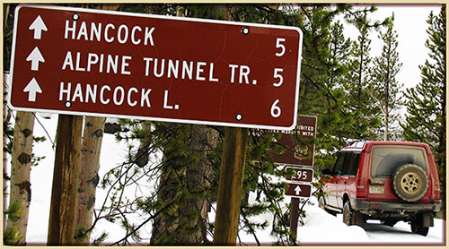

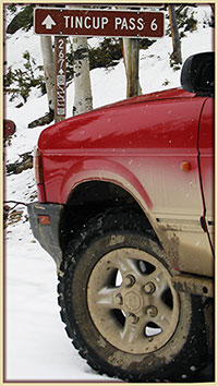 Review PREVIOUS YEARS trail status updates, dating back to 2001.