| TRAIL NAME |
NATIONAL FOREST NAME/ RANGER DISTRICT |
PHONE NUMBER |
STATUS |
DATE UPD. |
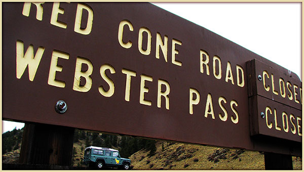
ALPINE TUNNEL
ROAD #839 |
Gunnison/Gunnison |
970-641-0471 |
CLOSED @
UPPER REACHES |
4/16/21 |
COMMENTS: Courtesy of trail-driver Josh B. :)
|
4/16/21
- Upper reaches of Alpine Tunnel Road FSR 839 remains closed to motorized vehicles.
- Marked as closed to motor vehicles for the foreseeable future. Horse and foot traffic only.
4/12/21 - Courtesy of Gunnison Ranger District.
- Avalanche Road Damage
- Unlikely that Alpine Tunnel road will be open for 2021.
|
| ALTA LAKES ROAD FSR 623 |
Uncompahgre GMUG
Norwood R District |
970-874-6600
970-327-426 |
|
|
COMMENTS:
|
|
ANIMAS FORKS
CR 9 /CR 2
11,160 ft. |
Uncompahgre/Ouray
San Juan County |
970-240-5300 |
OPEN |
5/20/21 |
COMMENTS: Courtesy of San Juan National Forest :)
|
5/20/21
- CR 2 Open.
|
ARGENTINE PASS ROAD FSR 724.1
LEAVENWORTH CREEK ROAD
FSR 248.1
Start A. Pass Road 11,594 ft.
A. Pass 13,207 ft. |
White River NF Dillon R District |
970-468-5400 |
OPEN
Partially |
11/21/21 |
COMMENTS: Courtesy of trail driver Don F. :)
|
11/21/21
- Leavenworth Creek Road FSR 248.1 The trail is partially open from the east approach to Argentine Pass.
- I encountered a very bad patch of ice near N39.66123,W105.74308 just about adjacent to the Sydney Mine.
- Due to the length of time it took me to get out of the icy situation, I was unable to check the other spur FSR 248.1B down by Leavenworth Creek before it got dark.
- The trail was clear up to about the Eva Mine Complex. After that, there was snow and intermittent ice until the large swath of ice near the Sydney Mine.
6/21/21-Courtesy of Keith T.
- We made it about 2/3 of the way to the top. Still blocked by snow up there, but is melting fast.
- Maybe another week until it is passable.
- Very rocky as usual. Also wet and slippery in spots. FYI, we were on dirt bikes.
- Creeks were very passable.
05/20/21 - Courtesy of Gary M.
- Leavenworth Creek Road FSR 248.1, the eastern approach to Argentine Pass Road (FSR 724.1,) is open to Leavenworth Creek Spur Road FSR 248.1P at around 10,780ft. Snow drifts kick in above this.
- However, the snow is melting rapidly so this report will probably be outdated in a few days.
|
| Aspen Ridge Road 185 / CR 175 / Bassam Park CR187 |
San Isabel |
719-486-0749 |
OPEN |
5/29/21 |
COMMENTS: Courtesy of dirt bike rider DJ N. :)
|
5/29/21
- All gates open.
- Some puddles but nothing serious. Was able to keep feet dry on a dirt bike.
|
BALD MOUNTAIN TRAILS/ MT BALDY ROAD FSR 520/ 520.1/ 520.3/ 528.1b/ 528.2
Jnt Boreas PassRd CR10 10,086 ft.
Iowa Mill 11,239.
Carbonate Mine 12,127 ft.
High point Upper Mt Baldy Road 12,575 ft. |
White River/
Dillon Ranger Dist
Summit County |
970-468-5400 |
OPEN |
7/21/21 |
COMMENTS: Courtesy of Dillon Ranger District. :)
|
7/21/21
- OPEN to highway legal vehicles.
- No ATVs, unlicensed motorcycles, or snowmobiles.
6/19/21 Courtesy of Joe S.
- Mount Baldy Road FSR 520 is OPEN per latest info from Dillon R.D.
- NOTE June 18, 2021: Dillon Ranger Conditions Report which lists all Mt Baldy trails as CLOSED, may need updating.
- Consider contacting ranger office at 970-468-5400 to clarify if upper trail segments are open.
- Been up Bald Mountain /Mt Baldy FSR #520/520.3/528.1b/528.2 after June 18, 2021?
- Share back status of trails?
- Share back photos to CO PASS Page at bushducksd@gmail.com
6/10/21 - Courtesy of Dillon Ranger District.
- Bald Mountain FSR #520/520.3/528.1b/528.2 are CLOSED to all motor vehicles, mountain bikes and e-bikes.
|
BALLARD ROAD
FSR 129 |
Canyon Lake Ranger District |
970-295-6700 |
CLOSED**
CAMERON PEAK FIRE |
7/1/21 |
COMMENTS: Courtesy of Canyon Lakes Ranger District. :)
|
7/1/21
** Closed due to Cameron Peak Fire.
|
| Bangs Canyon |
BLM |
Grand Junction |
|
|
COMMENTS:
|
|
BARBOUR FORK
FSR 194.2
B Forks TH 8,490
Devils Spur T/H 10,482 ft. |
White River/Dillon
Pike/South Platte |
970-468-5400
303-275-5610 |
OPEN |
6/28/21 |
COMMENTS: Courtesy of Clear Creek Ranger District. :)
|
6/28/21
- FSR 194 is OPEN.
|
BAXTER PASS ROAD
Garfield CR 201 |
BLM Grand Junction
|
202-208-3801 |
Partially Open |
4/10/21 |
COMMENTS: Courtesy of trail rider Rich H :)
|
4/10/21
- South side is passable to the top for jeeps and motorcycles. Some rock slides but enough room to get between the rocks, some mud, some snow.
- Still significant drifts on the north side.
- Fun on the big bike!
- Check out photos at Bushducks High Country Pass FB Update for Baxter Pass CR 201.
|
| Billings Canyon |
BLM |
Grand Junction |
|
|
COMMENTS:
|
|
Billings Lake/
North Fork S. Arkansas Road
CR 240.
Pride of the West Mine 12,011 ft.
Angel of Shavano
Camp 9,163 ft. |
Chaffee County/
Salida Ranger Dist |
719-539-4591
719-539-3591 |
OPEN **
Partially |
6/6/21 |
COMMENTS: Courtesy of Rick C. :)
|
6/6/21
- CR 240 is Open to North Fork Lake/Reservoir
- CR 240 is gated closed west of the North Fork Reservoir campgrounds.
- NFR lake ice is starting to melt.
- CR 240 to Billings Lake and Pride of the West Mine snow covered and blocked about half way between mine and North Fork Lake.
|
BILL MOORE LAKE ROAD FSR 183.1 /
RED ELEPHANT HILL ROAD FRS 173.1A
BM Lake 11,348ft
Jnct FSR 183.1C
11,118 ft. |
Arapaho NF /
Clear Creek R Dist |
970-295-6600
303-567-4382 |
OPEN |
7/18/21 |
COMMENTS: Courtesy of Scott D. :)
|
7/18/21
- Trail is OPEN and clear all the way to the lake.
- Not a trace of snow left (not surprisingly by this time of year). Trail is in good condition.
- What used to be whoop-de-whoops on the lower section are just ruts now.
- The mud bog by the lake is drier with easier entrance/exit ramps than I remember it last time I did this trail (2015).
- Lake is beautiful, as always. Great wildflowers this year.
- EXTREMELY BUGGY at the lake - bring bug spray!
- Sad to note - Lots of toilet paper "flowerettes" near the parking lot! Please pack it out or bury it!
- Oh, and there was a very friendly Empire Police Officer at the trail head handing out parking tickets to illegally parked trucks/trailers, so if you're parking here, pay attention to the signs, they are pretty clear.
6/12/21 - Courtesy of Daegan O.
- Bill Moore Lake trail is clear until the last climb around the ridgeline about 1/2 mile before the lake. Impassable snow at that point.
- I connected through and came out Red Elephant Hill Road FSR 171.3A which was clear.
- No report on the northern miller loop section as yet.
6/1/21 - Courtesy of Jim O.
- Red Elepahnt Hill Road FSR 173.1A is partially open.
- This trail is snow blocked 2 miles in, just behind the actual "red elephant hill".
|
| Birdseye Gulch |
Pike/South Park
Leadville County |
719-836-2031 |
|
|
COMMENTS:
|
| |
BLACK BEAR PASS
FSR 648 &
FSR 823
BB Pass 12,840 ft |
Uncompahgre/Ouray |
970-327-4835 |
CLOSED
GOT 2021 FOTOS OF
BLACK BEAR PASS?
Post-up at CO PASS Page FB |
11/10/21 |
COMMENTS: Courtesy of San Juan NF. :)
|
11/10/21
- Closed due to snow.
7/21/21 Courtesy of San Miguel County Sheriff.
- Trail OPEN - Travel Warning, Flash Flood Predictions AGAIN!
- Wednesday 7/21/21: Travel on Black Bear, Bridal Falls discouraged due to weather issues.
- See weather warning on the CO PASS Page FB
7/15/21 - Courtesy of San Miguel County Sheriff.
- Single vehicle roll-over on Black Bear Pass 7/15/21.
- Trail blocked by the vehicle just past Ingram Falls on Black Bear Pass.
** Trail temporarily closed at both ends until a tow can be a arranged.
- Occupants reporedly not injured. Got to be a mental nightmare given the shelf road location of the roll-over as can be seen on CO Pass Page FB.
- Best wishes going out to them! And yes, a reminder to the rest of us who love Black Bear - it can kill.
6/29/21 - San Miguel County Road & Bridge.
- Yes, Black Bear OPENED on June 28, 2021. Enjoy.
- Black Bear dozer driver in action - best job or what??!!
- San Miguel County R&B footage of the cleared trail in the classic zone, on Facebook.
- San Miguel Black Bear photos on CO PASS Page Twitter.
6/15/21 - Courtesy of San Juan National Forest.
- CLOSED. Black Bear Pass has not yet opened for 2021.
- Check out when Black Bear Pass first opened in 2020 on the CO PASS Page 2020
- See the sequence of events that CLOSED & OPENED Black Bear Pass thru 2020.
|
BLACKTAIL CREEK/ RADIUM ROAD
FSR 212.1 |
Routt Nat Forest
Yampa R District |
307-745-2300
970-638-4516 |
|
|
COMMENTS:
|
|
BLOWOUT PASS /
East Fork Pinos Road FR 329 /
Spring Creek Road 280 /
Dry Creek Road
FSR 264
B. Pass 11,774 ft. |
Rio Grande NF/
Divide Ranger Dist |
719-852-5941
719-657-3321 |
CLOSED
** |
5/14/21 |
COMMENTS:Courtesy of Divide Ranger District :)
|
* Northern approach to Blowout Pass via Pinos Creek Road FSR 329 is CLOSED. Mud and snow drifts remain.
* Dry Creek Road FSR 264 is CURRENTLY OPEN. This is the eastern end of Dry Creek Trail #700. No motorized vehicles on Tr #700.
|
| BOLAM PASS/ HERMOSA PARK ROAD FSR 578 |
Uncompahgre/Ouray
Columbine Ranger Dist /
Dolores Ranger Dist |
970-240-5300 |
OPEN |
6/16/21 |
COMMENTS: Courtesy of Greg S. :)
|
6/16/21
- I traveled east from CO 145 right thru to Purgatory ski area next to Hwy 550. Open all the way no problems. :)
- Bolam Pass photo on CO PASS Page FB.
6/15/21 - Courtesy of San Juan NF.
- Open to possible downed tree (mid May event)
5/20/21 - Courtesy of San Juan NF.
- FSR 578 Open to snow.
|
BOREAS PASS
Summit Co CR 10
Park County CR 33
Jnct Bald Mt Rd FSR 520 10,086ft
B. Pass 11,482 ft.
Como Cem 9,923ft |
White River/
Dillon Ranger Dist
Summit County
& Park County |
970-468-5400 |
OPEN |
9/19/21 |
COMMENTS: Courtesy of trail driver Peter @ Off-RoadX. :)
|
9/19/21
- Trail is open but very busy!
- Most people are in normal SUVs and some cars, so it is slow going.
6/12/21 - Courtesy of trail-rider Fin D.
- Boreas Pass Road is fully open.
- Rode over it on 6/12/2021 with no snow at all.
- North Tarryall Creek Crossing photo at Como end of the trail.
|
BREAKNECK & BROWNS PASSES
FSR 175 & 176
BK Pass 10,914 ft.
Browns Pass 11,374 ft. |
Pike/Fairplay |
719-836-2031 |
OPEN
Courtesy of MHJC Patrol 2! |
6/13/21 |
COMMENTS: Courtesy of Glenn G. @ Mile High Jeep Club Patrol 2. :)
|
6/13/21
- Adopt a trail crew went in early and cleared all fallen trees. So gate could OPEN June 15.
- Trail clear everywhere.
- Water crossing above 24" on deep side (E) 10" on right side (W).
- Birdseye view of Breakneck/Browns Passes on the CO PASS Page FB.
|
BROWN MOUNTAIN ROAD
FSR 884 / CR 20 |
Uncompahgre/Ouray |
970-327-4835 |
OPEN |
6/15/21 |
COMMENTS: Courtesy of Ouray County R& B :)
|
6/15/21
- Brown Mountain Road is OPEN.
|
BULL PARK ROAD
FSR 376.A |
Pikes Peak Ranger Dist |
719-636-1602 |
|
|
COMMENTS:
|
|
BUNCE SCHOOL TRAIL SYSTEM
FSR 115 & FSR 105
FSR 202 & FSR 203 |
Boulder |
303-541-2500 |
OPEN |
6/19/21 |
COMMENTS:
|
6/19/21
|
CALAMITY MESA
BLM 867/ 875/ 877 |
BLM Grand Junction |
(970) 244-3000 |
|
|
COMMENTS:
|
|
CALIFORNIA GULCH
CR 9.
Animas Forks Junct CR9 & CR2
10,998 ft.
Frisco Mill/ Bagley Tunnel 11,438 ft. |
Uncompahgre/Ouray |
970-240-5300 |
OPEN ** |
6/14/21 |
COMMENTS: Courtesy of Ouray County R&B + Jeff V. :)
|
6/14/21
** I did the Alpine Loop from Mineral Creek back around to Animas Forks. Drove down California Gulch to just before the pass and the
dozer was in front of a slide there. So Hurricane and California (Passes) a no go.
|
CALIFORNIA PASS
CR 19
Mountain Queen Mine 12,781 ft.
C. Pass 12,960 ft. |
Uncompahgre/Ouray
San Juan County |
970-240-5300 |
CLOSED |
11/10/21 |
COMMENTS: Courtesy of San Juan NF. :)
|
11/10/21
- Closed due to snow.
9/18/21- Courtesy of John K.
- Trail is OPEN all the way from both directions.
6/14/21 - Courtesy of Ouray County R&B & Jeff V.
- I did the Alpine Loop from Mineral Creek back around to Animas Forks. Drove down California Gulch to just before the pass and the
dozer was in front of a slide there. So Hurricane and California (Passes) a no go.
5/20/21 - Courtesy of San Juan Nat Forest.
- Closed.
|
Caribou Creek
FSR 505.1,
CR 116J, CR 128J |
Arapho-Roosevelt/ Boulder Ranger Dist |
970-295-6600
303-541-2500 |
OPEN |
7/10/21 |
COMMENTS: Courtesy of Pete L. :)
|
7/10/21
- Trail is now OPEN after Moose calving.
- Mud section is deep and rutted. Enjoy! :)
|
| CEMENT CREEK ROAD FSR 740 |
Gunnison/Gunnison |
970-641-0471 |
CLOSED
** |
4/12/21 |
COMMENTS:Courtesy of Gunnison Ranger Dist
|
04/12/21
- Cement Creek Road & Jeep Trail remains Closed.
** Over snow travel permitted.
|
| Chalk Mountain |
White River/Holy Cross |
970-827-5715 |
|
|
COMMENTS:
|
| |
CHIHUAHUA GULCH
FSR 263 |
White River/Dillon |
970-468-5400 |
|
|
COMMENTS:
|
|
CHINAMAN GULCH
BLM 6044 |
San Isabel/Salida |
719-539-3591 |
OPEN |
8/20/21 |
COMMENTS: Courtesy of Steve N. :)
|
8/20/21
- Trail is OPEN all the way.
- Note: Trail is non-stop obstacles even after your get to the top of the loop and start heading back to the beginning.
Must have 35", winch, lockers. Fun trail but very challenging.
|
CHINA WALL / BOX ROAD.
FSR 212 /FSR 204
Junct FSR 212 &
CR-77 8,772 ft.
China Wall crest 9,010 ft. |
Pike NF/
South Park R. Dist
Park County |
719-836-2031 |
OPEN |
6/19/21 |
COMMENTS: Courtesy of Brian C. :)
|
6/19/21
- Trail is dry.
|
Chinns Lake
FSR 174.1D
Chinns Lake 11,052 ft.
Junct FSR 174 10,405 ft. |
Clear Creek R. Dist
Clear Creek County |
303-567-3000 |
|
|
COMMENTS:
|
|
Cinnamon Gulch
FSR 262.1 |
White River/Dillon |
970-468-5400 |
Awaiting Feedback
Been here in 2021?
Share back??
Submit here. |
6/16/21 |
COMMENTS: Awaiting feedback.
|
|
CINNAMON PASS
San Juan CR 5
Hinsdale CR 30
Pass 12,640 ft. |
Uncompahgre/Ouray
BLM/Gunnison |
970-240-5300
970-641-0471 |
CLOSED |
11/10/21 |
COMMENTS: Courtesy of San Juan National Forest :)
|
11/10/21
- Closed due to snow.
5/20/21 - Courtesy of San Juan NF.
- Cinnamon Pass is open.
- Open from Silverton to Lake City.
|
CLEAR LAKE ROAD
FSR 815 /
SOUTH MINERAL ROAD FSR 585 |
Uncompahgre/Ouray
San Juan County |
970-240-5300 |
OPEN ** |
11/10/21 |
COMMENTS: Courtesy of Columbine Ranger District :)
|
11/10/21
** Snowy.
5/26/21Courtesy of Columbine Ranger District.
- Ice Fire Closure Extended.
**
Forest Order SJ-2021-02 entends the closure of Clear Lake Road FSR 815 and South Mineral Road FSR 585 to all public entry until September 15, 2021.
- South Mineral Creek Road FSR 585 closed at gate past Goldenhorn camping area.
|
CONEY FLATS
FSR 507.1
Beaver Reservoir Rd CR96 9,082 ft
Coney Flats T/H & Coney Creek crossing 9,781 ft.
Junct Middle St. Vrain Road
FSR 114.1
9,604 ft. |
Arapho-Roosevelt/ Boulder Ranger Dist |
970-295-6600
303-541-2500 |
CLOSED |
11/27/21 |
COMMENTS: Courtesy of Adam M. :)
|
11/27/21
- Coney Flats 4WD road is now seasonally closed.
- Tentative opening will be after the third weekend in June of 2022.
6/19/21 - Courtesy of Adam M.
- 4WD road is open all the way.
- Trailridge Runners 4WD Club did the seasonal opening. Replaced one downed sign and cleared a few trees.
- Trail is dry on lower section. Most mud holes are dry.
- Upper section water holes are full, as usual. Coney Creek crossing is high, but can be driven.
|
| Coon Hollow |
BLM Grand Junction |
303-239-3600 |
|
|
COMMENTS:
|
|
CORKSCREW GULCH / PASS FSR 886 / Ouray County Road 20A &
San Juan CR 11 |
Uncompahgre/Ouray
BLM/Gunnison |
970-240-5300
970-641-0471 |
CLOSED |
11/10/21 |
COMMENTS: Courtesy of San Juan Nat Forest. :)
|
11/10/21
- Closed due to snow.
6/7/21 - Courtesy of Ouray County Road & Bridge.
- Corkscrew Pass is officially OPEN for the season.
5/20/21
- Courtesy of San Juan National Forest.
- Corkscrew Pass is OPEN from Silverton only. Approach pass from east via San Juan CR 11 and part FSR 886.
- No status update on Corkscrew Gulch Road FSR 886 on the west side of Corkscrew Pass.
|
COTTONWOOD PASS
FSR 209/FSR 306
12,126 ft. |
San Isabel/Salida
Gunnison County |
719-539-3591
970-641-0044 |
OPEN |
6/3/21 |
COMMENTS: Courtesy of Mark M. :)
|
6/3/21
- According to Gunnison County public works Cottonwood Pass is open since 5/27/2021.
4/12/21 - COurtesy of GUnnison Ranger County.
- Closed.
|
Crooked Creek
FSR 194 / 669 |
Pike/South Park |
719-836-2031 |
AWAITING UPDATE.
Been there?
Going there?
Happy to share? |
|
COMMENTS: NONE YET :(
|
CLICK to SUBMIT your trail-status update.
Images? Easy, email Bushducks :) |
CUMBERLAND GULCH /
CUMBERLAND ROAD
FSR 271.1 |
Clear Creek |
303-567-3000 |
OPEN |
6/16/21 |
COMMENTS: Courtesy of trail-driver Josh B. :)
|
6/16/21
- Cumberland Gulch/Road is clear of snow.
- Expect wet conditions.
|
CUMBERLAND PASS FSR 765
C Pass 12,021 ft. |
Gunnison Nat Forest
Gunnison R District
Gunnison County |
970-641-0471
970-641-0044 |
OPEN |
6/29/21 |
COMMENTS: Courtesy of William C. :)
|
6/29/21
- Opened all the way in both directions.
- No snow from Tincup to Pitkin.
6/5/21 Courtesy of Pete O.
- Open to the summit from Pitkin, the south approach to Cumberland Pass.
- Closed on Tincup side, north side of Cumberland Pass, due to snowdrifts just below the summit.
- Cumberland Pass Road snowdrift on CO PASS Page FB
04/12/21 - COurtesy of Gunnison Ranger District.
- Cumberland Pass remains closed.
** Over-snow travel permitted.
|
CUNNINGHAM GULCH
San Juan CR 4
Highland Mary Lakes TH 10,830ft |
Uncompahgre/Ouray |
970-240-5300 |
OPEN |
6/15/21 |
COMMENTS: Courtesy of San Juan National Forest :)
|
6/15/21
- OPEN.
5/20/21 - Courtesy of SAn Juan NF.
- Open to snow.
|
Dakan Mountain Road
FSR 563 |
Pike/Fairplay
South Platte Ranger Dist |
719-836-2031
303-275-5610 |
|
|
COMMENTS:
|
|
DEER CREEK /
MONTEZUMA DEER CREEK ROAD CR 5
Junct Webster Pass Rd 10,525 ft
Teller Mountain 12,602 ft |
White River/Dillon
Park County |
970-468-5400 |
OPEN ** |
6/26/21 |
COMMENTS: Courtesy of trail-rider Josh B. :)
|
6/26/21
- CHATAUQUA MINE ROAD FSR 289.1, off Deer Creek Road. is OPEN.
- Old mining truck awaits restoration in wreckage of the mine building that slid down the hill to the lower track.
6/14/21 _ Courtesy of Josh B.
- Deer Creek Road is OPEN/Gate unlocked.
** Check out Josh's comment with his photo uploaded on Bushducks CO PASS Page FB.
6/10/21 - Courtesy of Dillon Ranger District
- CLOSED to all motor vehicles, mountain bikes and e-bikes.
4/21/21 - Courtesy of Dillon Ranger District.
- Closed.
** Open to over snow vehicles with a state registration.
|
| Democrat Mountain |
Arapaho/Clear Creek |
303-567-3000 |
|
|
COMMENTS:
|
|
DEVIL'S CANYON
FSR 246
Squaw Pass Road
Hwy103 9,895 ft
Devils Canyon TH 10,441 ft. |
White River/Dillon
Pike/
Clear Creek R.D. |
970-468-5400
303-567-3000 |
OPEN |
6/28/21 |
COMMENTS: Courtesy of Clear Creek Ranger District
|
6/28/21
- Devil's Canyon FSR 246 is OPEN.
|
| Dolores Point |
BLM |
Grand Junction |
|
|
COMMENTS:
|
| |
| Eagle Rock |
Teller County |
Near Colorado Springs |
|
|
COMMENTS:
|
|
| Eldorado Mountain |
Boulder |
303�541-2500 |
|
|
COMMENTS:
|
| |
Elwood Pass /
East Fork Rd
FSR 667 &
FSR 380
E Pass 11,650 ft. |
Rio Grande/Conejos
San Juan/Pagosa |
719-274-8971
970-264-2268 |
|
|
COMMENTS:
|
|
ENGINEER PASS
San Juan CR 18/
CR 17/FSR 878/CR 2
/Hinsdale CR 20.
Lake City 8,680 ft. E. Pass 12,790 ft. Animas Forks 11,200 ft. |
Uncompahgre/Ouray
BLM/Gunnison |
970-240-5300
970-641-0471 |
CLOSED |
11/10/21 |
COMMENTS: Courtesy of San Juan National Forest :)
|
11/10/21
- Closed due to snow.
6/15/21 Courtesy of San Juan Nat Forest.
- Engineer Pass is OPEN.
- Lower end Engineer Pass Road to Hwy 550 is OPEN.
- Don't look down! Hinsdale County dozer driver's motto, as witnessed by Michael Underwood Photography drone footage of the 2021 opening of Engineer Pass.
6/5/21 - Courtesy of Ouray Drew.
** Trail is open from Ouray Hwy 550 to 1.5 miles from Engineer Pass. Closed by snow bank at that point. Still, it's a good ride.
- NOTE: At point of closure it would be difficult to turn around in a jeep.
- However, you can see the closure point from previous switchback, so would recommend turning around there at previous switchback.
- We were on dirt bikes and traveled from Hwy 550 along County Road 18 (Engineer Pass Road), then on to County Road 17,
then up County Road 2 to the snow bank.
- See photo of snow blanket at around 12,700 ft. on County Road 2 above Mineral Point.
05/20/21 - Courtesy of San Juan National Forest.
** Open to the top from Silverton only. Travel via County Road 2.
** Engineer Pass Road FSR 878 Closed lower end to Hwy 550.
- No update on Hinsdale CR 20, the east route to Engineer Pass.
4/12/21 - Courtesy of Gunnison Ranger District.
- Closed.
|
EUREKA GULCH
San Juan CR 25 |
Uncompahgre/Ouray
San Juan County |
970-240-5300 |
CLOSED |
6/15/21 |
COMMENTS: Courtesy of San Juan National Forest
|
6/15/21
- Still CLOSED.
5/20/21 - Courtesy of San Juan NF.
- Closed.
|
| FOURMILE TRAVEL AREA FSR 311, 376, 376.B, 300 & more trails |
San Isabel/Salida |
719-486-0749
719-539-3591 |
OPEN |
8/9/21 |
COMMENTS: Courtesy of Steve N. :)
|
8/9/21
- Trails OPEN all the way in this area NE of Buena Vista.
- We started on CR 301 to Ruby Mountain and traveled onto different County Roads and ended up on main street in Buena Vista.
- Trail in good condition, the first section had the most washout areas but easy enough to travel on in a 4X4. I would not take this trail if any heavy rain is predicted if starting from Ruby Mountain trailhead. You can tell that they get flash floods through the trail area.
- Beautiful ride, we saw a herd of mountain goats on the day we rode the trail.
5/24/21 - Courtesy of Aaron J.
- Fourmile Area which consists of many trails in BLM and Forest Service lands just outside of Buena Vista is OPEN.
- 2-3 very, very, small mud areas, will probably dry up in 1-2 sunny days.
- This is a fun easy array of trails.
|
Garibaldi Gulch Rd
FSR 356.1
Junct FSR 354.1 10,552 ft.
Wise Mt. Cabin 12,054 ft.
Junct FSR 275.1 12,517 ft. |
White River/Dillon |
970-468-5400 |
|
|
COMMENTS:
|
|
GENEVA CREEK ROAD (UPPER)
FSR 119
Geneva Rd 9,722 ft.
Geneva Lake 10,989 ft
Sill Mine 11,808 ft. |
White River/Dillon
Pike/South Platte
Park County &
Clear Creek Co.
|
970-468-5400
303-275-5610 |
OPEN |
6/19/21 |
COMMENTS: Coutesy of Eric C. :)
|
6/19/21
- Upper gate is OPEN.
- No snow on trails. Two spurs to mine sites marked "no motor vehicles" now (hadn't visited in a couple of years), another had 2ft of standing water, did not attempt to cross.
4/25/21 - Courtesy of John KB.
- Upper Geneva Creek Road FSR 119 gated closed at the trailhead at Duck Creek Picnic Area/Campground.
|
GEORGIA PASS
South Fork Swan FSR 355
G Pass 11,585 ft. |
White River/Dillon |
970-468-5400 |
OPEN
|
7/21/21 |
COMMENTS: Courtesy of Dillon Ranger District. :)
|
7/21/21
- Georgia Pass (South Fork Swan) FSR 355 is OPEN to highway legal vehicles.
7/3/21 - Courtesy of Matt S.
- Georgia Pass is open to the top from the Breck side. No snow on the trail at all, but a few muddy spots.
- South side must be open also, saw a few SUVs up there with trailers that would not have made it up the Breck side.
- See Matt's photos at his Public Post on the CO PASS FB Community Page
6/10/21 - Courtesy of Dillon Ranger District.
- CLOSED to all motor vehicles, mountain bikes and e-bikes.
4/21/21 - Courtesy of Dillon Ranger Dist.
- Closed.
** Open to over snow vehicles with a state registration.
|
| Gold Hill/Switzerland Trail |
Boulder |
303-541-2500 |
|
|
COMMENTS:
|
| |
Goose Creek Road
CR211 |
Pike/Fairplay |
719-836-2031 |
AWAITING UPDATE.
Been there?
Going there?
Happy to share? |
|
COMMENTS: NONE YET :(
|
SUBMIT your trail-status update.
Images? Easy email Bushducks :) |
| Gordon Gulch |
Roosevelt National Forest |
970-498-1100 |
|
|
COMMENTS:
|
| |
GOVERNOR BASIN FSR 853.1C /
Ouray CR 26A |
Uncompahgre/Ouray |
970-240-5300
970 |
AWAITING UPDATE
Been here in 2021?
Submit trail update here. |
6/17/21 |
COMMENTS: Awaiting status update.
|
|
| Granite Creek Canyon |
BLM |
|
|
|
COMMENTS:
|
| |
Green Ridge Road
FSR 177 & 399.
From Lost Lake
CR 103 to CR 86 |
Araphoe Roosevelt/
Canyon Lakes R Dist
Larimer County |
970-498-1100
970-295-6700
970-498-5650 |
CLOSED ** |
7/1/21 |
COMMENTS: Courtesy of Canyon Lakes Rnager District. :)
|
7/1/21
- Closed due to Cameron Peak Fire.
|
GREER ROAD
FSR 154 |
Roosevelt National Forest |
970-498-1100 |
CLOSED **
Cameron Peak Fire |
7/1/21 |
COMMENTS: Courtesy of Canyon Lakes Ranger District. :)
|
7/1/21
** CLOSED due to the Cameron Peak Fire.
|
GRIZZLY LAKE /
GRIZZLY GULCH 4WD Road FSR 296 |
San Isabel/Salida |
719-539-3591
|
OPEN |
8/21/21 |
COMMENTS: Courtesy of Steve N. :)
|
8/21/21
- OPEN all the way.
- The gatekeeper as first obstacle after you cross the creek is very challenging. There were 4 of us and all had to use the winch point except for 1 who had 37's.
- After the gatekeeper it is 2 hours of uphill over boulders of varying sizes. Nothing big but lots of bouncing and banging around.
A few obstacles going up but not difficult to get over. Took 2 hours after getting past the gatekeeper and 1 hour on the return.
- Fun trail but need a lift. Lockers not needed, if getting winched up gatekeeper.
|
GUANELLA PASS Road
CR 62 / FSR 381
Duck Lake 11,112ft
G. Pass 11,669 ft. |
White River/Dillon
Pike/South Platte.
Clear Creek County
Park County |
970-468-5400
303-275-5610 |
CLOSED |
|
COMMENTS: Courtesy of Clear Creek Ranger Station :)
|
4/25/21
- Closed.
- Clear Creek County hopes the Guanella Pass Road will reopen on or about Friday, May 28, 2021.
|
| Gunsight Pass |
White River/Sopris District |
970-963-2266 |
|
|
COMMENTS:
|
| |
HACKETT GULCH
FSR 220
High Pt 8,890 ft. |
Pike National Forest
South Platte Ranger District |
303-275-5610 |
OPEN |
6/11/21 |
COMMENTS: Courtesy of William C. :)
|
6/11/21
- Hackett Gulch trail is OPEN.
- The access road, CEDAR MOUNTAIN ROAD Paso Country road 51, was a little rutty.
|
HAGERMAN PASS
FR 105 /FR 105.1
Lake I. 10,909 ft
H. Pass 11,925 ft
Carlton Tunnel east portal 10,795
Turquoise Lake
9,869 ft. |
San Isabel/Leadville
White River/Sopris |
719-486-0749
970-963-2266 |
OPEN **
Been thru Hagerman in Fall 2021?
Share back trail status HERE!
Post-up trail fotos HERE! |
9/13/21 |
COMMENTS: Courtesy of Don O. :)
|
9/13/21
- Went over from the Basalt side and went down on the other side about halfway. Didn't need to go any further. Camped at Molly Brown
and went over in my KLR and sidecar with my 3 kids ( dogs ). No problems or blockage anywhere. Totally clear.
7/30/21 - Courtesy of Peter Off-RoadX.com
- Trail was CLOSED.
- Surprised to find the trail closed. Unaware if it has re-opened since.
** 7/31/21: Talked with the USFS on another trail today and they said they did not know why Hagerman Pass was closed, or how long it will be closed.
7/15/21 - Courtesy of Ruth S.
- Yes, Hagerman Pass is OPEN again.
- On July 15th, we drove Hagerman Pass to the top and down a couple of miles on the other side. We had called the USFS because we had heard the pass was closed, also. The Pass was open, but the road from the Hagerman Trail on the west side leading into Gypsum (maybe Brush Creek Road?) was closed due to the Sylvan Fire.
- The USFS person we spoke to also said they were trying to keep unsuspecting drivers off of the trail, as it was sometimes coming up on GPS as an alternative to I-70 when Glenwood Canyon was closed, as it can be taken all the way into Aspen. Not sure if the gate has been closed since then.
7/2/21 - Courtesy of Joe M.
- Yes, Hagerman Pass is now OPEN.
- Gate was open near the top and trail was free from snow at the top. See trail scenes on FB.
- Drove over to Ivanhoe Lake and then turned around and headed back due to heavy rain.
5/25/21 - Courtesy of Hagerman B.
- We tried Hagerman Pass and we only made it 2 miles in before the snow got too deep.
|
HALFMOON CREEK/GULCH ROAD
FSR 110 |
San Isabel/Leadville
White River/Sopris |
719-486-0749
970-963-2266 |
CLOSED |
8/17/21 |
COMMENTS: Courtesy of Don H. :)
|
8/17/21
- Trail is still CLOSED.
- Closed for road maintenance by barricade just west of the East Halfmoon Campground, about a mile east of the Elbert trailhead.
- Yes, still closed pursuant to Forest Order https://www.fs.usda.gov/Internet/FSE_DOCUMENTS/fseprd933811.pdf.
- This Order will be in effect from the date of signature July 20, 2021 to August 31, 2021, or until rescinded, whichever event occurs first.
- North Elbert and South Mount Massive trailhead hikers will need to park along the sides of the road, about 1 mile from the Elbert parking lot.
7/2/21 - Courtesy of Joe M.
- FSR 110 was still closed, apparently for trail maintenance.
- Had to turn around at the Hiking Trailhead.
|
HANCOCK PASS ROAD FSR 299 /
HANCOCK JEEP TRAIL FSR 266
|
San Isabel/Salida
Gunnison County /
Chaffee County |
719-539-3591
970-641-0471 |
OPEN |
7/21/21 |
COMMENTS: Courtesy of trail rider Sean C. :)
|
7/21/21
- Trail is OPEN. No snow either side.
- Trail is like it was in past years.
6/13/21 - Courtesy of Beth T.
Hancock Pass is closed just below the summit on the Pitkin side (FSR 266, Hancock Jeep Trail side) by snow.
- Maybe a week or two out from melting.
- Looking soutwest, over to Tomichi Pass, it is a month or so out from melting.
Lots of snow still covering the road bed over there.
- See trail-driver Josh B.'s photo,
taken 6/20/21, of nearby Hancock Mine ghostown and Hancock Road FSR 295 on CO PASS Page FB.
- Nearby HANCOCK ROAD FSR 295 remains OPEN.
- Vehicles can travel as far at the turn around point on HANCOCK ROAD FSR 295, just before reaching Hancock Lake.
Foot, mountain bike and horse traffic only beyond there to Upper Hancock Lake and Chalk Creek Pass via Hancock Lake Trail #1422.
6/7/21 - Courtesy of trail rider Rick C.
** The trail is blocked by snow on the St Elmo side of the pass, about 1/2 mile from the parking area for the trailhead for the Alpine Tunnel trail.
|
HANDCART GULCH
FSR 121
W Pass 12,099 ft. |
White River/Dillon
Pike/South Platte |
970-468-5400
303-275-5610 |
OPEN |
8/15/21 |
COMMENTS: Courtesy of Scott D. :)
|
8/15/21
- Trail is OPEN all the way.
- Trail is in great condition.
- Very wet in the valley - beware!
- Looks like someone, Forest Service? A 4X4 club?? has ben doing work to maintain the trail and block the off-trail shortcuts - THANK YOU!
6/26/21 - Courtesy of Wil R.
- Trail blocked by a large mass of snow just below Webster Pass.
- Access the pass via RED CONE FSR 565 which was opened today by the Mile High Jeep Club :)
6/20/21Courtesy of Josh B.
- We went to Webster pass "Handcart Gulch Rd today and got someone returning saying Webster Pass is blocked at the top by snow bank.
- See Wils comment on Handcart Gulch Roadon the CO PASS Page FB.
|
HAYDEN PASS
FSR 970/
Hayden Creek Rd Fremont CR 6
Hayden Pass: 10,745ft |
Rio Grande/Saguache
San Isabel/Salida |
719-655-2547
719-539-3591 |
OPEN |
6/20/21 |
COMMENTS: Courtesy of Jeremiah C. :)
|
6/20/21
- Trail is OPEN both ways.
- Trail in good condition.
6/5/21 - Courtesy of Pete L. :)
- Off-RoadX cleared the trail. It is now OPEN!
- One tight area that is difficult near the top on the east side. Once snow melts more it will be easier to pass.
|
| Heart Lake Road FSR 518.1B & Carson Road FSR 518 & 7568 |
Rio Grande
Divide |
719-655-2547 |
|
|
COMMENTS:
|
|
| HERMIT PASS/ LAKE ROAD FSR 160 |
Rio Grande/Saguache
San Isabel/San Carlos |
719-655-2547
719-269-8500 |
|
|
COMMENTS:
|
|
| Hidden Valley Trail |
Pike/South Platte |
303-275-5610 |
|
|
COMMENTS:
|
|
HOLY CROSS CITY FSR 759
Start 9,360 ft
End 11,450 ft. |
San Isabel/Holy Cross |
970-827-5715 |
OPEN
Been here after early August 2021 rains?
Share back status. |
8/4/21 |
COMMENTS: Courtesy of White River NFS :)
|
8/4/21
- Access issue to Holy Cross City Road, resolved - Homestake Road FSR 703.1 has been RE-OPENED.
- Road surface repaired by Colorado Springs Uitilities.
8/3/21 - Courtesy of White River NF.
- Access issue: Temporary closure of access road Homestake Road FSR 703.1 due to heavy rains washout just below intersection with Holy Cross City Road.
- Aug 3 washout temporarily affects access to nearby Missouri Creek Road FSR 704.1, Fancy French Road FSR 727.1 and Homestake Reservoir.
- Homestake Road washout is being assessed by Eagle-Holy Cross Ranger District.
6/27/21 - Courtesy of trail-driver Bill V.
- I couldn't complete Holy Cross due to rain and it was too slick.
- Others went all the way and said it was open.
5/22/21 - coURTESY OF Eagle-Holy Cross Ranger District.
- FSR 759 Opens annually on 5/21, condition dependent.
- Access depends also on FSR 704 and 727. Usually passable mid-June, expect high water crossings.
|
HURRICANE PASS San Juan CR 10
12,730 ft. |
Uncompahgre/Ouray |
970-240-5300 |
OPEN |
9/18/21 |
COMMENTS: Courtesy of John Kennedy :)
|
9/18/21
- Hurricane pass is OPEN all the way. No issues at all.
- Trail was very busy and windy up there that day.
6/15/21 - Courtesy of San Juan National Forest
- Still Closed.
- Access to Hurricane Pass via California Pass on CR 19 is a no go due to dozer addressing a slide east of that pass on 6/14/21.
- Skip to California Pass update 6/14/21.
5/20/21- Courtesy of San Juan NF.
- Closed.
|
IMOGENE PASS
CR K68/
FSR #869/CR 26A
Telluride 8,875 ft
I PASS 13,114 ft
Junct I Pass Rd & CR26A 11,242 ft. |
Uncompahgre/Ouray |
970-327-4835 |
OPEN |
7/23/21 |
COMMENTS: Courtesy of San Miguel County Sheriff. :)
|
7/23/21
- Imogene Pass is OPEN once again after bridge concerns due to storm.
7/21/21 - Courtesy of San Miguel County Sheriff.
** Wednesday 7/21/21: Imogene Pass Temporarily Closed due to flash flood warning and bridge safety concerns.
- See CO Pass Page FB Update
6/18/21 - Courtesy of San Miguel Road & Bridge.
- CR K68 now cleared to Tomboy Mine.
- San Miguel Co R&B FB posting.
6/15/21 - Courtesy of San Juan Nat Forest.
- Pass still CLOSED.
6/8/21 - Courtesy of Ouray County Road & Bridge.
- Road maintenance crews continue to plow snow in the high country.
** Imogene Pass is in progress.
5/20/21 - Courtesy of San Juan National Forest.
- Imogene Pass Closed.
|
INDEPENDENCE PASS
Highway 82
12,095 ft. |
White River /
Aspen-Sopris Ranger District
Lake/Pitkin Counties |
970-945-2521
970-963-2266 |
OPEN ** |
7/31/21 |
COMMENTS: Courtesy of Peter Off-RoadX.com :)
|
7/31/21
- Road is very busy due to I-70 closures as a result of mudslides.
- Many oversized vehicles trying to make this route.
- There is now a 35ft limit in place.
** There is now a checkpoint on the Aspen side.
6/17/21 - Courtesy of Shawn F.
- Open and clear.
5/25/21 - Courtesy of Don H.
- Independence Pass was still closed yesterday, 5/24/21, at the 2nd gate with a sign that said, rock mitigation, with a mile number. I suspect they will open as usual on Thursday, 5/27/21.
4/13/21 - Courtesy of Aspen-Sopris Ranger District
- Closed.
|
| Independence Trail |
Canyon City |
|
|
|
COMMENTS:
|
| |
| Iron Chest Mine/ spur trail off San Isabel FSR 295 |
San Isabel/Salida |
719-539-3591
|
OPEN **
Partially |
6/20/21 |
COMMENTS: Courtesy of Josh B. :)
|
6/20/21
** I did not try the Iron Mountain/Chest mine as I met the local dire chief broke down in his Jeep and he said that road
minimum tires size is 37" and even then it is sketchy.
|
| ITALIAN CREEK ROAD FSR 759 |
Gunnison/Gunnison |
970-641-0471 |
OPEN |
8/1/21 |
COMMENTS: Courtesy of Peter Off-RoadX.com :)
|
8/1/21
- Trail is Open.
- Trail is in great condition!
6/30/21 _ Courtesy of William C.
- Note, I traveled from North to South on an ATV.
- Two small snow areas on North side, just prior to American Flag Mtn, passable (4x4 Jeep).
- Three muddy areas south of American Flag to Reno-Divide.
|
JENNY CREEK ROAD FSR 502.1 &
Jenny Creek Trail
FSR 808.1 |
Roosevelt NF
Boulder R District |
970-295-6600
303-541-2500 |
|
|
COMMENTS:
|
|
| JOHNNY PARK ROAD FSR 118 |
Canyon Lakes |
970-498-2770 |
OPEN |
7/1/21 |
COMMENTS: Courtesy of Canyon Lakes Ranger District. :)
|
7/1/21
- OPEN.
|
JONES PASS ROAD
FSR 144.1 |
Clear Creek |
303-567-3000 |
OPEN |
9/18/21 |
COMMENTS: Courtesy of trail driver Duane W. :)
|
9/18/21
- Trail is open all the way.
- Snow has melted completely and the road is in good shape.
8/4/21 - Courtesy of trail rider Josh B.
- Jones Pass trail is OPEN, yet still blocked by the snow blanket that invariably lingers on into the summer, at approx. 12,440 ft elevation, just east of cresting Jones Pass.
7/22/21 - Courtesy of Jay P.
- Jones Pass Road is OPEN, yet still blocked by snowbank.
- I traveled to the second switchback from the summit, but I could see from just above timberline the road was still blocked by snow just before the summit.
- Road was mostly dry and in good shape all the way to the second switchback.
- Snowbank at the summit appeared to be pretty substantial.
6/11/21 - Courtesy of Ryan B.
- Jones Pass will be closed June 14-30, 2021, as Denver Water does some maintenance up in the area.
- Culvert repair and replacement will mean a closure of a lower portion of the road on the east side of the Continental Divide.
- Additional access information at
Denver Water news 6/10/21 indicates DW will attempt to accommodate hikers and cyclists through the works area as conditions allow.
|
KEBLER PASS
Gunnison CR 12
10,007 ft. |
Paonia /
Gunnison County |
970-527-4131
970-641-0044 |
OPEN |
5/3/21 |
COMMENTS: Courtesy of Mark M :)
|
5/3/21
- According to gunnison county public works the road is open since 5/27/2021.
04/12/21 - Courtesy of Gunnison Ranger District.
- Closed.
|
KELLY FLATS /
WINTERSTEEN PARK ROAD.
FSR 168 & FSR 168.C
High Pt 7,830 ft |
Canyon Lakes |
970-295-6700 |
OPEN |
6/29/21 |
COMMENTS: Courtesy of Jeff & Canyon Lakes Ranger District. :)
|
6/29/21
- Kelly Flats Road FSR 168 in OPEN.
- Additional information on the trail and Kelly Flats campground and be found here.
|
KENDALL PEAK & KENDALL MTN.
San Juan CR 33 & Spur Trails |
Uncompahgre/Ouray |
970-240-5300 |
AWAITING UPDATE
Been here in 2021?
Submit trail update here. |
6/17/21 |
COMMENTS: Awaiting trail update.
|
|
KENNEBEC PASS/
LA PLATA CANYON ROAD CR 124
Kennebec T/H
11,624 ft. |
San Juan Public Lands
San Juan County /
La Plata County |
970-240-5300 |
OPEN **
Stage 1
Fire Restrictions |
6/15/21 |
COMMENTS: Courtesy of San Juan Nat Forest & La Plata County Commisioners :)
|
6/15/21
- La Plata County Road 124, access to Kennebac Pass remains OPEN to snow.
** Due to HOT & DRY conditions, STAGE 1 FIRE RESTRICTIONS
- Open burning ban go into effect on Wednesday June 16, 2021.
- Read more on Fire Restrictions
5/20/21 - Courtesy of San Juan NF.
- OPEN to snow.
|
td>
KINGSTON PEAK FSR 353.1
High Pt 12,051 ft. |
Clear Creek
Gilpin County |
303-567-3000 |
CLOSED |
10/16/21 |
COMMENTS: Courtesy of Lisa D. :)
|
10/16/21
- Trail not passable shortly before the summit, from the Alice side, and right before the James Peak Lookout. Snow drifts blocking
at the steep decline. Too deep to pass.
- We tried to get through the drift, lifted 1st gen 4Runner on 35s couldn't and had to be winched back.
- Pretty sure this is the GPS location: 39.847796, -105.661514
7/1/21 - Courtesy of Reuben R. & Clear Creek Ranger District.
- Seasonal gate still CLOSED.
- I called Clear Creek Ranger District and they said the gate WILL OPEN on July 15.
|
| LAMARTINE/SAXON MOUNTAIN ROAD FSR 712.1 & 712.2C |
Clear Creek |
303-567-3000 |
OPEN **
Been on Saxon Mountain in August 2021?
Share back trail status HERE!
Post-up trail fotos HERE!
|
8/2/21 |
COMMENTS: Courtesy of CORE. :)
|
8/2/21
** CORE announces Clear County is happy for the temporary closure of Saxon Mountain Road order to expire tomorrow.
- Stay The Trail has been given permission to install appropriate signage to inform the public of the technical issues involved in traveling the trail.
- Applause go out to Clear County, MHJC, CORE and Stay the Trail for their efforts in securing the reopening of this quality trail! A classic example of interested parties coming together over the table to highlight the public's desire to retain access and thru trail routes.
7/25/21 - Courtesy of Fort Lupton Press. :)
- Clear Creek County has closed a four mile section of Saxon Mountain Road due to rockslides and deteriorating road conditions.
- A rollover in early July plus concern for amateur drivers means the road will be closed for safety reasons from the base in Georgetown until about four miles up.
** A proposed 90 day closure has been reduced to a temporary closure that will apply through August 3, 2021, yet could be extended if necessary.
- A proposal has been put forward to allow 4x4 groups to work with the current short-staffed county R&B to stabilize the road.
- Saxon Mountain closure map, courtesy of Fort Lupton Press.
|
LA-SALLE PASS
FSR 44 & Park County CR 31
Pass 9,730 ft. |
Pike/Fairplay/
Park County |
719-836-2031
719 553-1400 |
OPEN
Been thru La-Salle Pass in 2021?
Share back trail status HERE!
Post-up trail fotos HERE! |
|
COMMENTS:
|
|
LAST DOLLAR ROAD FSR 638/
San Miguel CR T60.
Junct CR 58P 9,110 ft
Pass 10,663 ft.
Junct Deep Creek Road 8,790 ft. |
Uncompahgre/Ouray
Deep Creek Shop |
OPEN |
6/5/21 |
COMMENTS: Courtesy of Colorado Drew :)
|
6/5/21
- Last Dollar Road is open from Telluride all the way to Hwy 62 Ridgway.
- Surface was dry and clear the whole way. Rode on dirt bikes.
5/17/21 - Courtesy of San Miguel County Colorado Road & Bridge.
- San Miguel County R&B facebook page lists Last Dollar as Open.
- San Miguel County R&B website lists Last Dollar as Closed.
- Been along Last Dollar FSR 638 inside Uncompahgre NF lately?
- Can you confirm the trail is open all the way?
|
LEAD KING BASIN Road
FSR 315
Marble 7,961 ft.
Crystal 8,960 ft.
LK Basin 9,640 ft |
White River NF/ Aspen Sopris Ranger District |
970-945-2521
970-963-2266 |
OPEN |
7/19/21 |
COMMENTS: Courtesy of Aspen-Sopris Ranger District :)
|
7/19/21
- Lead King Loop FSR 314 & 315 is OPEN.
- HIGH CLEARANCE 4WD VEHICLE NEEDED.
6/12/21 _ Courtesy of Aspen-Sopris Ranger District.
- Lead King Basin is OPEN again after trail washout repairs.
- FSR 315 washout repair photos
4/13/21
- Expect snow!
|
| Left Hand Canyon |
Boulder |
|
|
|
COMMENTS:
|
| |
| LIME CREEK ROAD FSR 591 |
San Juan Nat Forest
Columbine R Dist |
970-247-4874
970-884-2512 |
OPEN **
Been here in 2021?
Update status here. |
6/17/21 |
COMMENTS: Awaiting June 2021 status update.
|
6/1/21- Courtesy of San Juan National Forest. :)
- Trail is Open to snow.
- Trail is not gated, not regularly monitored.
|
LOCH LOMOND
FSR 701
Junction Alice Road 10,357 ft.
Loch Lomond 11,192 ft. |
Clear Creek |
303-567-3000 |
OPEN ** |
6/28/21 |
COMMENTS: Courtesy of the Clear Creek Ranger District
|
6/28/21
- Loch Lomond (Lower) FSR 701.2 is OPEN.
** Loch Lomond (Upper) FSR 701.2 is CLOSED.
|
LONGWATER GULCH
FR 221 |
Pike National Forest
South Platte Ranger District |
303-275-5610 |
OPEN |
6/11/21 |
COMMENTS: Courtesy of William C. :)
|
6/11/21
- Longwater Gulch trail is OPEN.
- There was lots of 4x4 traffic on this trail today.
- The access road, CEDAR MOUNTAIN ROAD Paso Country road 51, was a little rutty.
|
Lost Canyon Road FSR 398
|
San Isabel NF
Leadville R District
Chaffee County |
719-553-1400
719-486-0749 |
OPEN |
8/27/21 |
COMMENTS: Courtesy of Scott D.
|
8/27/21;
- Trail is OPEN to the top.
- Definitely an underrated trail. We did this trail just to finish off the afternoon after our morning hike, but it is really quite
scenic at the top, especially on a crystal clear, post-Monsoon season day like today. There are wonderful views in all directions.
I suspect that the trail in underrated because the road is really very mild, with no significant obstacles, just a few mildly rocky spots.
- The road is signed as being closed to motor vehicles about 700 ft shy of the last T intersection at the top. To the left takes
you along the rim above Sheephead Gulch to Columbine Mine, at approx. 12,450 ft, but there is no gate and clearly, people have been ignoring the closure
signs - shame! If this beautiful area is ever fully closed, well, we'll all know why. Sigh!
- This would be a great fall color run as much of the lower section winds thru a huge Aspen stand, and once on top you have
great views of the Aspen stands on neighboring mountains.
- As for neighboring trails, we also did nearby FSR 399, Flume Gulch Road, a side trail off Lost Canyon Road which climbs above Twin
Lakes, but it just winds thru the forest, not much in the way of spectacular views on that one compared to Lost Canyon Road.
|
MAGGIE GULCH RD San Juan CR 23
Middleton 9,812 ft.
Gold Nugget Mine
at Top 11,894 ft. |
Uncompahgre/Ouray |
970-240-5300 |
CLOSED
Been here in 2021?
Share back status? |
6/15/21 |
COMMENTS: Courtesy of San Juan National Forest
|
6/15/21
- Still closed.
|
| Mammoth Gulch FSR 176.1 |
Boulder |
303-65533;541-2500 |
|
|
COMMENTS:
|
|
MARSHALL PASS
West side FSR 243
East side FSR 200
PONCHA CREEK ROAD FSR 203
M. Pass 10,842 ft. |
San Isabel N.F.
Gunnison R. Distr
Salida Ranger Distr |
970-641-0471
719-539-3591 |
OPEN |
6/3/21 |
| COMMENTS: Courtesy of Duane W. :)
|
6/3/21
- The main Marshall Pass Road, FSR 243 on west and FSR 200 on east side of the pass, is open and clear all the way.
- The alternative Marshall Pass east side trail, Poncha Creek Road FSR 203, is OPEN and mostly dry.
- There are two spots on Poncha Creek Road where the creek has overflowed onto the road, but the water is very shallow and easy to drive through. Kind of cool, actually.
5/27/21 - Courtesy of Jennifer S. @ NFS
- Xcel has completed their project work on the Gas Line and has removed their equipment on Marshall Pass.
- We were able to open the gates for Marshall Pass on the San Isabel side as well as the Gunnison side, this afternoon. The road is clear of snow.
- Marshall Pass Road map on CO PASS Page on FB.
04/20/21 - Courtesy of Jennifer S. @ NFS.
- Marshall Pass remains CLOSED through to the end of May due to uitility work.
04/12/21 - Courtesy of Gunnison Ranger District.
- FSR 243 Closed.
|
McALLISTER GULCH
FSR 708.1 |
White River/Holy Cross |
970-827-5715 |
CLOSED |
9/19/21 |
COMMENTS: Courtesy of Peter @ Off-RoadX. :)
|
9/19/21
- The gate on the Shrine Pass side is still closed.
9/13/21 - Courtesy of Luc S.
- McAllister Gulch/Ptarmigan Pass nearly 100% OPEN.
- The gate to the road that leads to the bridge and Shrine Pass Road was closed. So, you have to start and end on the Camp Hale side.
- Trail was in surprisingly good shape. The steep climbs are very steep, but seem to be in good repair overall.
7/7/21 - Courtesy of Eagle-Holy Cross Ranger District.
- McAllister/Hornsilver FSR 708 is OPEN.
|
MEDANO PASS
FSR 559 /CR 559
Point Of NoReturn
8,393 ft.
M. Pass 10,038 ft
Hwy-69 7,661 ft. |
Rio Grande NF/
SaguacheRangerDist
San Isabel Nat For
GreatSandDunes NP |
719-852-5941
719-655-2553
719-553-1400
719-378-6395 |
OPEN |
6/20/21 |
COMMENTS:Courtesy of Jeremiah C. :)
|
6/20/21
- Trail is OPEN both ways.
- Trail in good condition.
05/21/21 - Courtesy of NPS Great Sand Dunes.
- Medano Pass Primitive Road is partially open up to the 4th creek crossing, 6.4 miles (10 km) from the southern entrance of the road. The road is gated at this location.
- Heavy snow fell on the park and preserve May 18, delaying the opening of the road.
- The road is gated on the east side of the range at Muddy Creek crossing, USFS.
- Primitive campsites in the lower part of Medano Canyon are now accessible by high-clearance 4WD vehicle.
- The pass road will fully reopen when snow and road conditions allow, typically late May.
- Sand conditions are average. Most high-clearance 4WD vehicles can make it through sandy sections without dropping air pressure. Drive through sand as fast as safely possible in 4 Low gear; momentum is important in sand.
- Creek crossings are moderate. Drive through crossings slowly, steering toward the uphill side to avoid the deepest holes.
- NPS Medano Pass Primitive Road Map includes GSD National Preserve campsite locations and hiking trails.
|
METBERRY GULCH
FSR 205
Start 8,585 ft. End 7,145 ft. |
Teller County.
South Platte Ranger District |
303-275-5618 |
OPEN |
6/11/21 |
COMMENTS: Courtesy of William C. :)
|
6/11/21
- Metberry Gulch Trail is OPEN.
- The access road, CEDAR MOUNTAIN ROAD Paso Country road 51, was a little rutty.
|
Middle St. Vrain
FSR 114.1
Peaceful Valley Camp 8,531 ft.
Camp Dick 8,639ft
Buchanan Pass
Trailhead 9,617 ft |
Arapho-Roosevelt/ Boulder Ranger Dist
Boulder County |
970-295-6600
303-541-2500 |
OPEN |
6/19/21 |
COMMENTS: Courtesy of Adam M. & Boulder Ranger District :)
|
6/19/2
- 4WD road is open all the way through.
- Trailridge Runners 4WD Club did the seasonal opening. Cleared downed trees and maintained water bars. Replaced some "no camping" signs.
- Water is up this year. All creek crossings can be driven.
|
MILLER CREEK
FSR 172.1/
RED ELEPHANT HILL RD FSR 171.3A |
Arapaho NF/
Clear Creek R Dist
Clear Creek County |
970-295-6600
303-567-3000 |
OPEN |
7/18/21 |
COMMENTS: Courtesy of Scott D. :)
|
7/18/21
- We didn't do Red Elephant Hill, but did the Mill Creek Road loop as an offshoot to Bill Moore Lake. Trail in good condition.
- Great wildflowers this year in the few open meadows.
- EXTREMELY BUGGY - bring bug spray!
- This trail is almost entirely in a dense forest, and as such it really isn't very scenic. In fact, the trail is quite tight with lots of tippy spots that threaten to put your body panels into tree trunks or boulders. We were fine in a short wheelbase vehicle, but I can't imagine it would be much fun in, say, a 4-door Wrangler.
- Oh, and there was a very friendly Empire Police Officer at the trail head handing out parking tickets to illegally parked trucks/trailers, so if you're parking there, pay attention to the parking signs, they are pretty clear.
|
Miller Rock
FSR 252 & 252.1A
Junct Riverside Rd 7,835 ft
MillerRock 8,635ft
Junct Overland Dr 8,439 ft. |
Boulder |
303-541-2500 |
OPEN |
N/A/21 |
COMMENTS: Courtesy of Adam H. & Boulder Ranger District. :)
|
N/A/21
- *Caution* The main obstacle (north side of St. Vrain River) has an illegal bypass that is being used. This use has dislodged the large log that is holding the road in place below the obstacle. This condition will make the lower part of the obstacle very challenging. Please be careful.
- The Trailridge Runners 4WD Club is working with the Boulder Ranger District on a repair plan. It will most likely not happen until next year.
|
MINERS CREEK
FSR 1000.1 |
White River/Dillon Ranger District |
970-468-5400 |
OPEN |
6/18/21 |
COMMENTS: Courtesy of trail-rider Josh B. :)
|
6/18/21
- Trail remains OPEN.
- There are two crossings of Miners Creek along this trail. Neither is very deep right now.
- See Josh's photo of the easy creek crossing up on CO PASS Page FB.
6/10/21 - Courtesy of Dillon Ranger District.
- Trail OPEN: Lower [County] and Upper [USFS] Gate to highway legal vehicles.
- No ATVs, unlicensed motorcycles, or snowmobiles.
4/21/21 - Courtesy of Dillon Ranger District.
- CLOSED: Lower and Upper Gate, to all motor vehicles, mountain bikes and e-bikes.
|
| MINER'S GULCH/ NORTH CLEAR CREEK ROAD FSR 709.1/ 705.1 |
Arapaho Nat Forest
Clear Creek R Dist
Gilpin County |
970-295-6600
303-567-3000 |
|
|
COMMENTS:
|
|
MINERAL CREEK
SAN JUAN COUNTY ROAD 17.
Mineral Point Mill 11,550 ft
Junct CR-17 & CR-2 12,038 ft. |
Uncompahgre/Ouray
Ouray County &
San Juan County |
970-240-5300 |
OPEN
Been here Fall 2021?
Share trail status here. |
9/18/21 |
COMMENTS: Courtesy of John K. :)
|
9/18/21
- Trail Open all the way.
- There was a Toyota Tacoma rollover about a mile or two from the start of the trail on Hwy 550. It is not blocking the trail.
6/15/21 - Courtesy of San Juan Nat Forest.
- Mineral Point ghost town accessed via CR 17 still closed.
- 6/14/21 UNCONFIRMED report of CR 17 being open.
|
MINNIE GULCH RD San Juan CR 24
Junct CR 24 & CR2
9,901 ft.
M Gulch Trailhead 11,590 ft. |
Uncompahgre/Ouray
San Juan County |
970-240-5300 |
OPEN |
6/20/21 |
COMMENTS: Courtesy of Frank W. & BLM :)
|
6/20/21
- Road is OPEN all the way and dry.
- The county has done some work near where the road crosses the creek (culvert). Everything is in good shape.
- We took the spur road up to the Kitti Mack Mine and saw a bull moose. Evidence of a recent avalanche, but the road was completely cleared.
- Kitti Mack Mine located at N37.86500 W107.53700. Elevation 11,683 ft.
6/15/21 - Courtesy of San Juan Nat Forest.
- Still Closed.
5/20/21 - Courtesy of San Juan NF.
- Closed.
|
MOODY HILL
FSR 513
off Buckhorn Rd.
Then FR 132+ 344 to Crystal Mtn.
Start 9,694. ft
Moody Hill 7,895
Crystal Hill 9,730 |
Canyon Lakes RD
Larimer County |
970-295-6700
970-498-5650 |
CLOSED **
CAMERON PEAK FIRE |
7/1/21 |
COMMENTS: Courtesy of Canyon Lakes Ranger District
|
7/1/21
** CLOSED due to the Cameron Peak Fire.
|
| MOON/GAMBLE GULCH FSR 411.1 |
Boulder |
303-541-2500 |
OPEN |
6/19/21 |
COMMENTS: Courtesy of Peter L. :)
|
6/19/21
- Trail is OPEN.
- Trail is generally in good condition.
- Heading north, just before campsites is a 4ft deep mud hole. Avoid at all costs by going wide of puddle on the east side of the trail.
|
MOSQUITO PASS
Park Co. CR 12
Lake Co. CR 3
Start 10,934 ft
Pass 13,185 ft |
Pike/South Park
Lake County &
Park County |
719-836-2031 |
OPEN
Done MOSQUITO Fall 2021?
SHARE BACK STATUS HERE
Post-up Fotos @ CO PASS Page FB |
10/8/21 |
COMMENTS: Courtesy of trail-driver Eric M. :)
|
10/8/21
- Mosquito Pass is still/again OPEN all the way, and in good shape.
- Just some tiny remnants of last week's snow by the trail high up on the Leadville side.
- Encountered just two other vehicles, saw a couple more at a distance.
- More snow expected soon... Expect change in trail status!
9/4/21 Courtesy of Scott D.
- Trail still OPEN.
- Very busy trail on a Saturday! At least this is one of Colorado's high mountain shelf roads that generally has room to pass
oncoming traffic. This time we tried the side roads that branch off just below London Mill (Alma side of the pass):
Oliver Twist Lake - The route to this lake is quite short and easy, in fact it is smoother and easier than Mosquito Pass Rd itself.
It's an interesting lake with mining structures above treeline.
- Cooney Lake - If you continue on past Oliver Twist Lake on FSR 452, the road gets much rougher, with 2-3 mildly technical obstacles, and a
deep water crossing (at least 24-30 inches deep). However, the reward is another gorgeous high-mountain lake at approx. 12,600 ft!
8/29/21 - Courtesy of Paige C.
- Trail continues to be open all the way.
- Honestly thought the trail was in decent shape - rocky and all, but that's normal. Had a great run, passed 10-15 vehicles plus motorcycles.
8/9/21 - Courtesy of trail driver Jeff.
- Trail is OPEN, again.
- Trail conditions? As you'd expect. Not a cheeky comment, but just as expected.
8/4/21 - Courtesy of Mark R H.
- Mosquito Pass currently closed.
- Entered trailhead at Hwy 9 from Hwy 285 side. Encountered yellow sign warning Mosquito Pass CLOSED. Turned around and drove to the Ranger station in Fairplay. We were told that Mosquito Pass is not being maintained and is dangerous for all travel except small vehicles (bikes and SXS vehicles). We did not attempt.
7/30/21 _ Courtesy of Peter @ OFF-ROADX.com
- Trail is OPEN!
- Trail is in great condition.
7/10/21 - Courtesy of KN G.
- Mosquito Pass is OPEN.
- There are reports as of 7/9/21 of vehicles making it through the snow.
7/8/21 - Courtesy of trail-driver Moe P.
- Mosqito Pass, almost open!
- One snow blockage remains right before the turn down to the mines.
6/27/21 - Courtesy of Josh B.
- Mosquito Pass is still closed.
- The area at the false summit is deep snow.
- I met up with two other guys on bikes and they confirmed no way anything is going over from the east (Alma) side but a snow machine.
- You can get a long way past the New London mine now.
- Pirate Road FSR 856, spur trail off Mosquito Pass Road, is open all the way to the end around 12,600 ft, below Mount Buckskin rising to 13,796 ft.
Trail is good, see photos, rock crawler best option in places. Deep puddles too.
6/16/21 - Courtesy of trail-rider Josh B.
- Mosquito Pass snow blockade still remains in place above the 12.5K elevation.
- Check out Mosquito Pass Road water crossing photo on CO PASS Page FB
6/14/21 - Courtesy of trail-rider Josh B.
- Park County Road 12 Trail looks almost identical from the easy east side, Alma side, of Mosquito Pass.
- Road stopped at 12,369 feet right at the North London Mine, then it is DEEP snow, no sign of the road where it passes the mine.
- Snow closure photo on east side of Mosquito Pass at North London Mine.
- Snow closure photo near mine parking area.
6/10/21 - Courtesy of trail rider Rick C.
- Still closed due to snow at first switchback on Leadville side at about 12,300 ft.
- Seems like the trail is rockier than normal with less sand and small rocks than normal. Might be due to the large amount of late snow.
- Mosquito Pass snow closure photos up on the CO PASS Page FB.
5/27/21 - Courtesy of trail snow-shoeing Don H.
- No surprise, Mosquito Pass west side approach County Road 3 is still impassible.
- The trail is bad as soon as you turn onto the start of the rough section at Diamond Mine at Evans Gulch Reservoir #2.
- See Mosquito Pass Update photo on Bushducks FB, where County Road 3 is well outlined by the deep snow visible on the road as
it winds its way up to the pass between Kuss Peak to the north and Mt. Evans to the south.
- See wildflowers emerging as the trail clears! Expect slow to no travel above Conley Lakes, unless you packed the snow shoes.
|
MOUNT ANTERO 4WD ROAD FSR 278.A/
Upper Browns County 4WD Road FSR 278/
Baldwin Creek Road FSR 277 |
San Isabel/Salida |
719-539-3591
|
OPEN |
8/22/21 |
COMMENTS: Courtesy of Steve N. :)
8/22/21
- Both trails open all the way to the top.
- Trail in good condition to the top of Antero and to Baldwin Lakes. Crazy windy at the top the day we traveled. Beautiful views on the way up. Not many on the trail on a Sunday.
8/7/21 - Courtesy of Brian C.
- Trails are OPEN and dry all the way to the top.
|
| Mount Baldy/Captain Jacks |
Pike National Forest/ El Paso County |
719-836-2031 |
|
|
COMMENTS:
| | |
MOUNT BLANCA/ LAKE COMO
FSR 975
Junct Hwy-150 7,648 ft.
Lake Como 11,803 ft. |
Rio Grande/ Saguache/
Conejos Peak R Dist
Alamosa County |
719-655-2547
719-274-8971 |
|
|
COMMENTS:
|
|
| MOUNT BROSS FSR 787 Plus More Trail # |
Pike/South Park |
719-836-2031 |
|
|
COMMENTS:
|
|
| Mount McClellan |
Arapaho/Clear Creek |
303-567-3000 |
|
|
COMMENTS:
| | |
MOUNT PRINCETON
FSR 322 /
LUCKY MINE ROAD
FSR 322.A
Mount Princeton Trailhead 8,918ft
Bristlecone Park Chalet 12,124 ft.
|
San Isabel/Salida |
719-539-3591
|
OPEN ** |
6/12/21 |
COMMENTS: Courtesy of Loren S. :)
| 6/12/21
- Mount Princeton Road FSR 322 is OPEN.
** Lucky Mine Road FSR 322.A, the upper section of this overall trail, is NOT OPEN all the way. There is snow blocking the way at about 11,670 ft. elevation.
|
| MOUNT ZION 4WD FSR 109 |
San Isabel NF/ Leadville R Dist |
719-553-1400
719-486-0749 |
|
|
COMMENTS:
|
|
NAPOLEON PASS
Southside FSR 540
North/Tincup-side
via Mid Ridge Rd FSR 953.1
Junct FSR 765 10,693 ft.
Nap Pass 12,040ft
Tincup 10,138 ft. |
Gunnison Nat Forest
Gunnison R District
Gunnison County |
970-641-0471
970-641-0044 |
OPEN |
9/4/21 |
COMMENTS: Courtesy of Paige C. :)
| 9/4/21
- Trail is OPEN all the way through.
- Someone/some group has done a lot of work clearing trees in the forested
section on the Tincup side of the pass - Thank you, whomever you are!
- We ran it in a 4-door Jeep Rubicon, no problems at all. Tight trail and rocky coming up the south side, and tight through the
trees on the north side (Tincup side), but again, doable all the way. Met up with some hunters on ATVs in the pass, passed several
side-by-sides and ATV as we drove north (they were going south).
- Trail is in decent shape and as expected after reading the Charles Wells guidebook: rocky in places, muddy & wet in others. Easily
doable by our Rubicon.
6/9/21
- Courtesy of Beth T.
- We traveled from the Pitkin side on FSR 540. This trail is blocked by two patches of snow just below the summit on the Pitkin side. Maybe 1-2 weeks still before it melts.
- We then hiked to the pass from the blockade, and found there are a few patches of snow on the Tincup side as well.
- Snow closure point photo just below the summit on the CO PASS Page FB
6/6/21 - Courtesy of Pete O.
- Napoleon Pass Trail FSR 540 is CLOSED due to snow blockades on the south side, the Pitkin side of the pass.
- Napoleon Pass snow closure photo on Pitkin side on CO PASS Page FB.
|
| No Name Gulch FSR 705 |
White River/Holy Cross |
970-827-5715 |
OPEN |
7/7/21 |
COMMENTS: Courtesy of Eagle-Holy CrossRanger District. :)
| 7/7/21
- Trail is OPEN.
5/22/21
- Road opens 5/21 annually if conditions allow.
- Usually still snow near top on opening day.
|
| North Fork Reservoir Road |
San Isabel/Salida |
719-539-3591 |
|
|
COMMENTS:
| | |
Ohio Pass/ Ohio Creek Road FSR 730
Ohio Pass 10,098ft |
Gunnison NF/ Gunnison County
Gunnison Ranger District |
970-641-0471
970-641-0471 |
CLOSED
** |
4/12/21 |
COMMENTS: Courtesy of Gunnison Ranger District :)
| 04/12/21
- Closed.
** OPENS May 27, 2021.
|
OLD FLOWERS RD
FSR 152 |
Canyon Lakes |
970-295-6700 |
PART OPEN
** |
7/1/21 |
COMMENTS: Courtesy of Canyon Lakes Ranger District. :)
| 7/1/21
** Old Flowers - OPEN between Stove Prairie Road and Pingree Park Road..
|
OPHIR PASS
FSR 630, FSR 679
Junct Hwy 550 10,083 ft.
Ophir Pass 11,789. Ophir 9,850 ft. |
Uncompahgre/Ouray |
970-327-4835 |
OPEN |
5/27/21 |
COMMENTS: Courtesy of San Miguel County Colorado Road & Bridge :)
| 5/27/21
- Early openers! Ophir Pass is open in time for the holiday long weekend.
5/11/21 - Courtesy of Columbine Ranger District.
- Ophir Pass Road FSR 679 Open on east side; closed at pass.
|
OTTO MEARS TOLL ROAD FSR 869/
TOLL ROAD GULCH/
UPPER KERBER EAST ROAD /
County Road 47YY |
San Isabel/Salida
Salida Ranger Dist
Saguache Ranger District |
719-539-3591
719-655-2547 |
OPEN |
6/25/21 |
COMMENTS: Courtesy of George R. :)
| 6/25/21
- Historic toll road OPEN all the way.
- All Fallen trees cut out.
- A few narrow spots requiring care to pass.
- There is a serious mud hole at the Bonanza end, south end of the trail.
|
OWL CREEK PASS
FSR 858.
Junct FSR 858 & CR8 7,789 ft.
OC Pass 10,114 ft |
Uncompahgre/Ouray
BLM/Gunnison |
970-240-5300
970-641-0471 |
OPEN |
6/8/21 |
COMMENTS: Courtesy of Ouray County R&B :)
| 6/8/21
- Owl Creek Pass is OPEN.
5/20/21 - Courtesy of San Juan NF.
- Closed.
|
| Pace Lake Road |
BLM Grand Junction |
303-239-3600 |
|
|
COMMENTS:
|
|
Peak 9 Trail
FR248 |
White River/Dillon |
970-468-5400 |
|
|
COMMENTS:
|
|
| Peak 10 Trail |
White River/Dillon |
970-468-5400 |
|
|
COMMENTS:
| | |
PEARL PASS
FSR 738
P Pass 12,705 ft. |
White River NF
/GMUG NF
Gunnison R Dist.
Pitkin &
Gunnison County |
970-945-2521
970-874-6600
970-641-0471 |
OPEN |
8/22/21 |
COMMENTS: Courtesy of Brian PJ :)
| 8/22/21
- Trail OPEN all the way, Crested Butte, to Aspen.
- Trail is as last reported, beautiful lush green!
- This is my 7th crossing in 14 years. Last year and this year on the Crest Butte side very little traffic, 2 motorcycles last year and one motorcycle and one ATV. I only mention this as I am a solo traveler and I keep thinking if I break down it could be a long wait for help.
- Quite rocky but so enjoyable!
- On the Aspen side 5 or 6 vehicles and several hikers.
8/1/21 Courtesy of Peter Off-RoadX.com
- Trail remains OPEN.
- Very lush scene due to all the rain. Waterfall on north side of trail is bigger than we have ever seen, just beautiful!
- Lots of mud holes and rock crawling is slippery when wet.
7/28/21 - Once again, courtesy of Carl B. + Mattie :)
- Pearl Pass is OPEN for 2021.
- No snow remains on the road.
- Peer at Pearl image by Mattie.
- Pearl Pass Road map
- View at North side of Pearl Pass loolking at Pearl Mountain July 28, 2021.
- Front row window view by Mattie
6/28/21 - Courtesy of Carl B.
- Pear Pass is blocked with snow, on the Aspen side, about a half mile beyond the Taggert and Wilson huts.
- Pearl will not be passable until sometime in August.
- If you want to go anyway, bring a shovel and be prepared to dig some snow.
|
| Pennsylvania Gulch Boulder County CR 95J.0 |
Roosevelt National Forest |
970-498-1100 |
OPEN |
7/10/21 |
COMMENTS: Courtesy of Off-RoadX Pete. :)
| 7/10/21
- Nothing out of the normal. The trail's V notch is just a little deeper this season.
|
| PERU CREEK ROAD FSR 260 |
White River/Dillon |
970-468-5400 |
OPEN |
6/14/21 |
COMMENTS: Courtesy of trail-traveler Josh B. :)
| 6/14/21
- Peru Creek Road is OPEN to all motorised vehicles.
- FSR, Forest Service Roads Status photo on CO PASS Page FB.
6/10/21 - Courtesy of Dillon Ranger District.
- OPEN to ATVs and unlicensed motorcycles.
|
PICAYUNE GULCH / PLACER GULCH
San Juan CR 9
Treasure Mtn Mine 11,590 ft.
Parson Lake / Gulch view point 12,635 ft |
Uncompahgre/Ouray
/San Juan County |
970-387-8040 |
CLOSED |
6/15/21 |
COMMENTS: Courtesy of San Juan National Forest :)
| 6/15/21
- Still CLOSED.
5/20/21 - Courtesy of San Juan NF.
- Closed.
|
PICKLE GULCH / BLACKHAWK RD.
FSR 718.1
Junct Missouri Gulch Road CR 15S 9,105 ft.
Junct Stewart Gulch FSR 714.1 10,115 ft. |
Arapaho NF /
Clear Ck R District
Gilpin County |
303-567-4382 |
OPEN |
6/19/21 |
COMMENTS: Courtesy of Off-RoadX Pete. :)
| 6/19/21
- Trail is OPEN.
- Nothing abnormal about trail.
|
| Pinyon Mesa |
BLM/Grand Junction |
|
|
|
COMMENTS:
| | |
POLE HILL FSR 122
Hwy-36 8,035 ft.
Panorama Peak 9,283 ft. |
Canyon Lakes R Dist |
970-498-2770 |
OPEN |
7/1/21 |
COMMENTS: Courtesy of Canyon Lakes Ranger District. :)
| 7/1/21
- OPEN.
|
POMEROY LAKE ROAD
FSR 297.
Junct of FSR 295 10,567 ft.
Lake parking 12,089 ft. |
San Isabel/Salida |
719-539-3591 |
OPEN |
6/20/21 |
COMMENTS: Courtesy of Josh B. :)
| 6/20/21
- Pomeroy Lake and Mountain Road FSR 297 as well as spur trail to Mary Mountain Mine sites remain OPEN.
- I did not try the nearby Iron Mountain/Chest mine trail as I met the local dire chief broke down in his Jeep and he said that
road minimum tires size is 37" and even then it is sketchy.
6/12/21 - Courtesy of Loren S.
- Pomeroy Lake Road is OPEN all the way.
6/7/21 - Courtesy of Rick C.
- FSR 295 blocked by deep snow about 1 mile past the remains of the Mary Murphy Mine Building, at around 11,200 ft.
- There are a couple places of snow till about 1 to 1.5 miles past the mine remains, then the snow is a couple of feet deep.
|
PORPHYRY GULCH /
BULLION KING ROAD FSR 822
| Uncompahgre/Ouray |
970-240-5300 |
OPEN
Done Porphyry Gulch / Bullion King Road Road in 2021?
SHARE BACK STATUS HERE
Post-up Fotos @ CO PASS Page FB
|
7/27/21 |
COMMENTS: Trail is OPEN.
| 7/27/21
- Trail had probably been OPEN for weeks, as there was no snow anywhere.
- Easy drive.
- The only issue would be meeting another vehicle on the shelf road.
|
POUGHKEEPSIE GULCH FSR 876 /
LAKE COMO
San Juan CR 58 |
Uncompahgre/Ouray |
970-240-5300 |
OPEN
|
6/30/21 |
COMMENTS: Courtesy of Deanna S. :)
| 6/30/21
- Poughkeepsie Gulch Trail is OPEN for the season!
- I would like to thank the volunteers from the Western Slope 4 Wheelers who have worked many hours to get this trail open
and the multiple hours to keep it open for the public! We hope you all get to enjoy this trail this summer!
- However, on a less than positive note, we would like to let the public know that we found more trail damage this year. We found
several sets of new SxS and at least one full sized vehicle with aggressive mud terrain tires that bypassed the bottom gate in an
attempt to run the trail. They apparently turned around when they ran into snow, as we did not find any tracks in the snow from them.
The damage can be seen from a satellite map from last year at N 37° 57.233 W 107° 37.591.
- This has prompted the USFS to look at relocating the lower gate closer to the trail head to prevent this from happening again.
- The WS4W did drag a bunch of trees across the access spot to this in an attempt to block future people from crossing the
Uncomphagre River at that spot.
- If you have any knowledge on who damaged this land and accessed a closed trail prior to its opening, we ask you to contact
Officer Stone with the USFS in Montrose at this number 970-240-5300.
6/15/21 - Courtesy of San Juan National Forest.
- Now CLOSED for revegetation until further notice.
5/20/21 - Courtesy of San Juan NF.
- Closed.
|
PTARMIGAN (PASS) ROAD / RESOLUTION ROAD
FSR 751/FSR 702 |
White River/Holy Cross |
970-827-5715 |
OPEN |
8/8/21 |
COMMENTS: Courtesy of Tom P. :)
| 8/8/21
- You can loop Ptarmigan Pass and Resolution Road trails which start and end at Camp Hale off Hwy 24.
- FYI - Wearyman Creek Road FSR 747.1 (which links thru to Shrine Pass Road 709.1 and Mc Allister Gulch Road FSR 708.1) is washed out and gated about a mile away.
|
RADICAL HILL
FSR 286.1 & FSR 286.1B |
White River/Dillon
Pike/South Platte |
970-468-5400
303-275-5610 |
OPEN ** |
7/23/21 |
COMMENTS: Courtesy of trail-driver Josh B. :)
| 7/23/21
** Multiple washouts on Radical Hill Road today due to the storm.
- One major washout around 12,400 ft elevation, on the south face of Teller Mountain was too
much to surmount as the weather closed in on us. We attempted repairs to the trail, yet had to give up due to rocks sliding down the face of the mountain. Scary!
- The Jeep that joined in with trail repairs was able to turn around at the washout. We were in a longer wheelbase truck, so had to back up Radical Hill as the clouds rolled in. Not a fun activity!
- The Jeep from the other side said it was washing out coming up from the cabin and likely impassable now as well.
- After the snow and hail it was a complete downpour.
- Planning to ride my dirt bike up there tomorrow morning to check the status.
- Hopefully there will be enough people up there tomorrow that we can team up and hit it with shovels, but its gonna take some work.
7/3/21 - Courtesy of trail-drivers Red S. & Daniel W.
- Just went all the way through Radical!
- See snow trail scene before you reach the cabin & switchbacks.
7/1/21 - Courtesy of Josh B.
- I did not go down Radical Hill, but there are two significant snow drifts across it.
- However, it looked at though motorcycles and bikes had made it through.
|
RAMPART RANGE
FSR 300 |
Pike/South Platte |
303-275-5610 |
OPEN |
6/16/21 |
COMMENTS: PSICC National Forest. :)
| 6/16/21/
- The Rampart Range Recreation Area Designated Dispersed Campsites are now live for reservations on Recreation.gov
|
RED CONE ROAD
FSR 565
Webster Pass 12,099 ft.
Red Cone 12,786 ft.
Jnct Hall Valley Rd 9,879 ft. |
White River/Dillon
Pike/South Platte
Park County |
970-468-5400
303-275-5610 |
OPEN |
10/2/21 |
COMMENTS: Courtesy of trail-driver Drew @ RM4X4. :)
| 10/2/21
- Trail is OPEN all the way. North side descent should be attempted with extreme caution.
- Typical Red Cone conditions until about 11,000 ft where it is slightly muddy in the trees. Final ascent to the summit of Red Cone
is slushy but doable if you've made it that far.
- The North side descent is currently very dangerous from the recent snow above 12,500ft. About 3-4ft of wet snow blankets the first
descent from the top. Some side-by-sides and ATVs were able to make the slippery descent. Reports of one Wrangler sliding down the
entire hill, as a result, no other 4x4 rigs attempted the descent from the summit today. Subsequent descents were in good shape.
- Webster Pass was clear.
- Good weather this coming week might melt the snow cap enough to keep Red Cone passable for a few more weeks.
8/3/21 - Courtesy of Doug H.
- Ran Red Cone with a group of old CJ's.
- There's a large hole that has developed in the steepest part of the descent, that I don't recall being there before.
Pretty nerve wracking when your front tire drops into it!
6/26/21 - Courtesy of trail-rider JOsh B.
- Red Cone was opened today by volunteer group Mile High Jeep Club :)
- Handcart Gulch Road remains CLOSED due to a large amount of snow just below Webster Pass.
** Red Cone is one-way travel, you have to get to Red Cone from West of the Divide, south of Breck. Then there is no easy return to 285 via dirt, you have to go down to Montezuma, through Keystone->Dillon->Frisco->Breck.
6/20/21 - Courtesy of trail-driver Daniel W.
- Red Cone gate is CLOSED.
|
| Red Canyon Park |
Canyon City |
|
|
|
COMMENTS:
| | |
| RICHMOND HILL ROAD CR 15E |
Gunnison/Gunnison |
970-641-0471 |
OPEN |
8/23/21 |
COMMENTS: Courtesy of Scott D. :)
| 8/23/21
- Trail OPEN and in great shape.
- The broken-down snowmobile is still there! (It is well off the trail and not blocking anything.)
- Wonderful views of the Maroon Bells - Snowmass Wilderness from the top.
7/31/21 - Courtesy of Peter Off-RoadX
- Trail is OPEN and in good condition.
- Watch for disabled snow mobile at about halfway point. USFS says it has been there since winter.
|
RIMROCKER TRAIL
Montrose CR-90 & many road numbers.
Pioneer Camp at Buckeye Reservoir 7,633 ft. |
BLM Uncompahgre Field Office
County of Montrose
Town of Nucla |
970 240 5300
970-249-7755 |
OPEN |
5/14/21 |
COMMENTS: Courtesy of Mark C. :)
| 5/14/21
- Open all the way from Montrose to Moab.
- Buckeye Reservoir is very low.
- We took the Moab to Gateway route via Castle Valley on our return and it's open as well.
|
ROLLINS PASS East Side AKA CORONA PASS ROAD
FSR 149 |
Arapho-Roosevelt/ Boulder Ranger Dist |
970-295-6600
303-541-2500 |
OPEN ** |
7/6/21 |
COMMENTS: Courtesy of Hannah P. :)
| 7/6/21
- Corona Pass FSR 149 is OPEN from the West side all the way to the top where it becomes Rollins Pass.
** FSR 149 is no longer permitted as a through-way. Only approach from West or East. Not permissible to connect the two ends of FSR 149 in a vehicle.
6/3/21 - Courtesy of Brent S.
- Rollins Pass east side, AKA Corona Pass Road, is not open all the way.
- I got 7 miles up the trail and started running into many areas with deep snow covering the road. Eventually couldn't go no further.
- Trail is not bad, but there is snow, deep ruts, mud and water on it. Like I said, not open all the way.
4/2/21 - Courtesy of Boulder Ranger District.
- Open. NFSR 149 (12 miles of Rollins Pass Road from CR16 to the closure is open - no winter maintenance)
|
ROLLINS PASS West Side AKA CORONA PASS ROAD
FSR 149 |
Arapaho/Sulphur |
970-887-4100 |
|
|
COMMENTS:
|
|
RED & WHITE MOUNTAIN FSR 734
Eastern Junct of FSR 734 & 700 9,661 ft.
R&W Mt 11,190ft
Western Junct of FSR734 & FSR700 10,462 ft. |
White River /
Eagle-Holy Cross |
970-945-2521
970-827-5715 |
OPEN |
7/7/21 |
COMMENTS: Courtesy of Eagle-Holy Cross Ranger District. :)
| 7/7/21
- Trail is OPEN.
5/22/21 - Courtesy of Eagle-HOly Cross Ranger District.
- Road slated to open June 21, condition dependent.
|
SAINTS JOHN
FSR 275
Montezuma 10,271
Wild Irishman Mine 11,711 ft
Mt Glacier 12,443 |
White River/Dillon |
970-468-5400 |
OPEN |
7/21/21 |
COMMENTS: Courtesy of Dillon Ranger District. :)
| 7/21/21
- OPEN to ATVs and unlicensed motorcycles.
6/14/21 - Courtesy of Josh B.
- Saints John Road is OPEN/Gate unlocked.
- Check out Josh's comment with his photo uploaded on Bushducks CO PASS Page FB.
6/10/21 - Courtesy of Dillon Ranger District.
- CLOSED to all motor vehicles, mountain bikes and e-bikes.
|
SANTA FE PEAK
FSR 264
High Pt @ Sarsfield Mine 12,702 ft. |
White River/Dillon
Summit County |
970-468-5400 |
OPEN |
7/21/21 |
COMMENTS: Courtesy of Dillon Ranger District. :)
| 7/21/21
- OPEN to highway legal vehicles.
- No ATVs, unlicensed motorcycles, or snowmobiles.
6/14/21 - Courtesy of trail-traveler Josh B.
- Santa Fe Peak Road is OPEN/Gate unlocked.
- Check out Josh's comment with his photo uploaded on Bushducks CO PASS Page FB.
6/10/21 - CLOSED to all motor vehicles, mountain bikes and e-bikes.
|
| Saran Wrap |
Pike National Forest |
Near Colorado Springs |
|
|
COMMENTS:
|
|
SCHOFIELD PASS ROAD FSR 317
Crystal 8,960 ft.
Sch Pass 10,707ft
Gothic 9,467 ft. |
White River/
Aspen-Sophris Ranger District |
970-945-2521
970-963-2266 |
OPEN
Got fotos of Schofield Pass 2021?
Post-Up! |
7/19/21 |
COMMENTS: Courtesy of Aspen-Sopris Ranger District. :)
| 7/19/21
- Trail is passable.
- HIGH CLEARANCE 4WD VEHICLE NEEDED.
7/6/21 - Courtesy of Aspen-Sopris Ranger District.
- Schofield Pass is passable with a few snow fields.
05/19/21 - Courtesy of Rob J.
** Road closed by a gate ~1.5 miles outside Gothic.
- Trail OK, some ruts from when the road was softer.
- Travel should be doable to the snow-plug once the gate opens.
04/12/21 - Courtesy of Gunnison Ranger District:
- Closed. Snow packed.
OPEN TO SNOW TRAVEL.
|
SCOTCH CREEK ROAD FSR 550.1
/HOTEL DRAW RD
FSR 550
Junct Hwy-145 8,674 ft.
Junct Highline Trail 10,359 ft.
Junct FSR-578 9,171 ft. |
San Juan Nat For/ Dolores Ranger Dist |
970-247-4874
970-882-7296 |
OPEN ** |
6/15/21 |
COMMENTS: Courtesy of San Juan National Forest :)
| 6/15/21
- Scotch Creek, Open.
** Incredibly rough road, suggest Roaring Fork as alternative.
5/20/21 - Courtesy of San Juan NF.
- Scotch Creek Road is open to snow.
|
| SEVENMILE FSR 225 |
San Isabel/Salida |
719-539-3591 |
CLOSED ** |
7/1/21 |
COMMENTS: Courtesy of Canyon Lakes Ranger District. :)
| 7/1/21
** CLOSED due to the Cameron Peak Fire.
|
| Sheep Creek |
BLM Mesa County |
|
|
|
COMMENTS:
| | |
| Sheridan Hill |
Clear Creek |
303-567-3000 |
|
|
COMMENTS:
| | |
| SHEEPHORN MOUNTAIN FSR 401 |
White River |
970-468-5400 |
OPEN
|
7/7/21 |
COMMENTS: Courtesy of Eagle-Holy Cross Ranger District. :)
| 7/7/21
- Trail is OPEN.
5/22/21 - Courtesy of Eagle-Holy Cross Ranger District.
- Road slated to open June 21 condition dependent.
|
SHRINE PASS
FSR 709.1 |
White River /
Holy Cross R.Dist/
Dillon Ranger Dist |
970-945-2521
970-827-5715
970-468-5400 |
OPEN |
9/19/21 |
COMMENTS: Courtesy of trail-driver Peter @ Off-RoadX. :)
| 9/19/21
- Trail fully open and in good shape.
6/27/21 - Courtesy of Bill V.
- OPEN all the way.
- Road is in great shape, with no snow packs.
6/27/21 - Courtesy of Saul A.
- Open and clear all the way.
- Sign at beginning said open to over snow vehicles only but there were other folks out.
- I passed a Forest Service truck and they just waved, so I figured the sign was perhaps in the process of being updated.
- A few puddles along the way but road is clear end to end.
6/10/21 - Courtesy of Dillon & Eagle-Holy Cross Ranger Districts.
- CLOSED to all motor vehicles, mountain bikes and e-bikes.
- Road opens 6/21 annually if conditions allow.
|
SIDNEY BASIN
FSR 853.1C1 |
Uncompahgre/Ouray |
970-240-5300
970 |
|
|
COMMENTS:
|
|
Slate River Road/Paradise Divide
FR317, FR734 |
Gunnison |
970-641-0471 |
|
|
COMMENTS:
| | |
SLAUGHTERHOUSE (GULCH) RD FSR 105
CROW CREEK ROAD FSR 101 |
Pike/South Platte
South Platte
Ranger District |
303-275-5610
303-275-5610 |
OPEN |
6/17/21 |
COMMENTS: Courtesy of South Platte Ranger District :)
| 6/17/21
- Parking improvements underway at Slaughterhouse Gulch parking area.
- Expect machinery, road crews, volunteers June 19-20.
- PSICC National Forest notification of parking improvements on their FB.
5/30/21 - Courtesy of Huntinbob06.
- The gate is open. Trail is free from snow all the way.
4/25/21 - Courtesy of John KB.
- Slaughterhouse Road FSR 105 and Crow Creek Road FSR 101 still gated closed at trailhead - more than likely to minimize trail damage during muddy spring melt conditons.
|
SLIDE LAKE 4WD
ROAD FSR 145
S Lake 11,708 ft.
Junct FSR 705 11,571 ft. |
White River NF &
San Isabel NF/
Leadville R Dist &
Holy Cross R Dist |
970-945-2521
719-553-1400
719-486-0749
970-827-5715 |
OPEN
GOT FALL 2021 FOTOS OF SLIDE LAKE 4WD ROAD?
POST UP! |
9/19/21 |
COMMENTS: Courtesy of Peter @ Off-Road X. :)
| 9/19/21
- Trail is open and in good shape.
- Rocky, but nothing too technical.
8/28/21 - Courtesy of Scott D.
- Trail is OPEN all the way.
- Trail is very, very rocky! There are no technical obstacles, but for most rigs this is a low gear + low range, walking-pace drive
requiring careful tire placement from the very beginning all the way to the end. If the first 1/4 mile isn't your cup of tea, turn
around, because it doesn't get any better, and in fact gets a little bit worse!
- The trail ends unceremoniously at a small, wooded parking area with a few primitive campsites near a 10th Mountain Division backcountry hut.
From there it is a 0.5 mile hike to Slide Lake itself, which is as pretty an alpine lake as I've ever seen. The water is crystal clear!
|
SPRING CREEK TR FSR 712.2/
SILVER CITY ROAD FSR 712.2J
Start 8,125 ft.
Finish 11,118 ft. |
Arapaho/Clear Ck Ranger District/
Clear Creek County |
303-567-3000
303-567-4382 |
|
|
COMMENTS:
|
|
SPRING CREEK ROAD FSR 744
Start 8,506 ft.
Finish 11,237 ft. |
Gunnison/Gunnison
Gunnison Ranger District |
970-641-0471
970-641-0471 |
CLOSED
** |
4/12/21 |
COMMENTS: Courtesy of Gunnison Ranger District :)
| 4/12/21
- Closed.
** Open to over-snow travel.
|
STILLWATER PASS ROAD FSR 123/CR4
West end Junct CR 125 8,832 ft.
Illinois T/H 9,011
High Point East of
Gravel Mountain 10,634 ft.
East end Junct CR-34 8,316 ft. |
Arapaho Roosevelt/ Sulphur Ranger Dist |
970-887-4100 |
OPEN |
9/18/21 |
COMMENTS: Courtesy of trail driver Duane W. :)
| 5/18/21
- Road is completely open and in good shape.
- Forest in the area of the road FSR 123 (and Kawuneeche Road FSR 120.0) has been utterly devastated by the fire. Nothing but scorched trees as far as
you can see in all directions.
5/26/21 - Courtesy of Sulphur Ranger District.
- Trail is CLOSED due to fire impact.
|
STONY PASS /
RIO GRANDE RES ROAD
FSR 520/CR 18
& CR 3
S Pass 12,650ft |
Rio Grande N Forest
Divide Ranger Dist
San Juan County
& Hinsdale County |
719-480-3364
970-527-4131
970-944-2291 |
OPEN ** |
6/15/21 |
COMMENTS: Courtsy of San Juan National Forest :)
| 6/15/21
- Open to Pole Creek.
** Water is fast in Pole Creek. Use EXTREME caution.
5/20/21 - Courtesy of San Juan NF.
- Rio Grande Reservoir Road FSR 520, the south approach to Stony Pass, is OPEN to Pole Creek.
- Water is rising in Pole Creek. Use EXTREME caution.
- No update on CR 3 the north route to Stony Pass.
|
SUMMITVILLE ROAD
FSR 330
PARK CREEK ROAD
FSR 380
ALAMOSA-CONEJOS ROAD FSR 250 |
Rio Grande NF/
Conejos Peak R Dist
Divide Rang Dist
| 719-852-5941
719-480-9892
719-850-2374 |
Partially Open
** |
5/14/21 |
COMMENTS: Courtesy of Divide Ranger District :)
| 5/14/21
* Summitville Road FSR 330 OPEN.
* Park Creek Road FSR 380 OPEN from Park Creek to Pinos Creek.
* Alamosa-Conejos Road FSR 250 per undated report from Conejos Peak Ranger District that gate is open from Hwy 17 to Kerr Lake. Check with Connejos Peak R, Dist before travel.
|
SWAN RIVER ROAD
- MIDDLE FORK
FSR 6.2
Start 9,830 ft.
High Pt 12,619 ft |
White River/Dillon
Summit County |
970-468-5400 |
OPEN |
6/10/21 |
COMMENTS: Courtesy of Dillon Ranger District :)
| 6/10/21
- OPEN to ATVs and unlicensed motorcycles.
4/21/21 - Courtesy of Dillon Ranger Dist.
- Closed.
** Over snow vehicles permitted on designated routes only. See MVUM.
|
SWAN RIVER ROAD - NORTH FORK
FSR 354.1
Jnct CR6 9,775 ft
Top of North Fork 11,526 ft. |
White River/Dillon |
970-468-5400 |
OPEN |
6/10/21 |
COMMENTS: Courtesy of Dillon Ranger District :)
| 6/10/21
- OPEN, Both Gates, to ATVs and unlicensed motorcycles.
4/21/21 - Courtesy of Dillon Ranger District.
- Closed.
** OPEN to over snow vehicles with a state registration.
|
| Swan River Road - South Fork FSR 355.1 |
White River/Dillon |
970-468-5400 |
CLOSED
** |
4/21/21 |
COMMENTS: Courtesy of Dillon Ranger District :)
| 4/21/21
- Closed
** Open to over snow vehicles with a state registration. |
TABERGUACHE TRAIL FSR 544.1A/
DOMINGUEZ ROAD
FSR 408 |
BLM Grand Jct./
Ouray Ranger Dist |
202-208-3801
970-240-5300 |
Partially Open ** |
5/14/21 |
COMMENTS: Courtesy of Grand Valley Ranger District Update
| 5/14/21
** Lower Dominguez Road FSR 408 OPEN. Gate opened 5/6/21
** Mid-Dominguez Road FSR 408/408.1A Jct Open. Gate opened 5/6/21 |
TAYLOR MOUNTAIN
CR 228/ FSR 330
Garfield 9,505 ft.
High Point / Iron Duke Mine 12,642 |
Chaffee County |
719-539-6961 |
|
|
COMMENTS:
|
|
| TAYLOR PASS ROAD FSR 761 |
Gunnison/Gunnison
Pitkin Co &
Gunnison Co |
970-641-0471 |
OPEN |
7/31/21 |
COMMENTS:Courtesy of Peter Off-RoadX.com :)
| 7/31/21
- Taylor Pass Road is OPEN.
- Creek is a little higher than normal due to rain.
- The pass and creek trails are OPEN.
7/6/21 - Courtesy of Mario SA.
- Open all the way.
- First time going through so unsure of usual conditions but it's fully passable, very rocky and rough, no snow anywhere on the trail.
|
TINCUP PASS
FSR 267
St Elmo 10,010 ft T. Pass 12,154 ft
Mirror Lake 10,962 ft.
Tincup 10,138 ft. |
San Isabel/Salida
Gunnison County /
Chaffee County |
719-539-3591
970-641-0471 |
OPEN |
10/22/21 |
COMMENTS: Courtesy of trail driver Dave D. :)
| 10/22/21
- We traveled St. Elmo to Tincup Pass summit. Open and passable to summit.
- Some patches of snow covered area in the trees.
- Did not continue past summit, it looked open though.
6/20/21
- Courtesy of trail-shoveler Marcus T. at CORE.
- We (CORE) shoveled out Tincup Pass yesterday. It is fully OPEN!
- See CORE's trail clearing photos on the CO PASS Page FB
6/20/21 - Courtesy of trail rider Josh B.
- Tin cup pass not open. Too much snow.
- Mary Murphy mine sites on spur trail off Pomeroy Lake and Mountain Road, FSR 297, are OPEN.
- I did not try the Iron Mountain/Chest mine as I met the local dire chief broke down in his Jeep and he said that road minimum tires size is 37" and even then it is sketchy.
6/7/21 - Courtesy of trail rider Rick C.
- Trail is closed on the east side (Saint Elmo side) of the divide before you start the switch back.
- Deep snow across the trail, streams running a little high than mormal.
- No visible washouts and on the east side of Tincup it looked like county had been up there earlier and did some drainage work.
|
TOMICHI PASS
FSR 888 |
Gunnison/Gunnison |
970-641-0471 |
OPEN |
6/27/21 |
COMMENTS: Courtesy of CORE :)
| 6/27/31
- Tomichi Pass is now OPEN due to the hands-on efforts of the CORE Trail Crew.
- Beware, when approaching the rockslide area from the Hancock Pass side, the slope is steep and loose
6/27/21 Courtesy of trail-rider Beth T.
** Looking at Tomichi Pass from over at Hancock Pass to the northwest, there is a lot of snow visibly covering Tomichi Pass road bed.
- Best guess, it is a month or so out from melting.
|
TRANSFER TRAIL
FSR 602 |
White River / Rifle Ranger District |
970-468-5400 / 970-625-2371 |
OPEN ** |
6/11/21 |
COMMENTS: Courtesy of Rifle Ranger District. :)
| 6/11/21
** Open to Windy Point.
- Hip Roof Park has some snow.
- Can get to Blue Lake.
|
TREASURE MOUNTAIN LOOP
San Juan CR 9
Treasure Mtn Mine 11,590 ft.
Parson Lake / Gulch view point 12,635 ft |
Uncompahgre/Ouray |
970-240-5300 |
CLOSED |
6/15/21 |
COMMENTS: Courtesy of San Juan National Forest
| 6/15/21
- Still Closed.
5/20/21 - Courtesy of San Juan NF.
- Closed.
|
| Turner Gulch |
Pike/Fairplay |
719-836-2031 |
|
|
COMMENTS:
| | |
TWIN CONES
FSR 126 |
Pike, South Platte
South Platte R Distr |
719-836-2031
303-275-5610 |
OPEN |
6/6/21 |
COMMENTS: Courtesy of Ben F. :)
| 6/6/21
- Open all the way to top.
- Few snow drift less than 12" with tracks through in two spots on flat before climb to top.
- No snow on upper rocky climb.
- Creek crossing near private land about 8" deep.
- Aerial view of North Twin Cone Peak on Bushducks FB
5/12/21 - Courtesy of Tony
- Gate remains closed.
- Trail not expected to open prior to 6/16/21 |
| UNCOMPAHGRE DIVIDE ROAD FSR 402 |
Uncompahgre NF/
Grand Valley R Dist
Ouray Ranger Dist |
970-242-8211
970-240-5300 |
Partially Open ** |
5/14/21 |
COMMENTS: Courtesy of Grand Valley Ranger District Update
| 5/14/21
* Divide Road #402 Boundary Gate: OPEN. Gate opened 5/1/21.
* Divide Road #402 /Telephone Trail(#657) Gate: OPEN. Gate opened 5/6/21.
* Divide Road #402 /Divide Forks Gate: OPEN. Gate opened 5/8/21.
* Divide Road #402 /Mesa Creek (#407): CLOSED - Not accessible by full size vehicle. Closed to all vehicles over 50" wide until roadbed is dry. |
| Uncompahgre Plateau Area |
Grand Valley |
970-242-8211 |
|
|
COMMENTS:
| | |
URANIUM ROAD
FSR 404 |
Uncompahgre NF/
Grand Valley R Distr |
970-242-8211 |
OPEN |
5/14/21 |
COMMENTS: Courtesy of Grand Valley Ranger District Update
| 5/14/21
- Uranium Road/Indian Creek #404 OPEN.
- Gate opened 5/6/21. |
| Wager Gulch |
Uncompahgre/Ouray
BLM/Gunnison |
970-240-5300
970-641-0471 |
|
|
COMMENTS:
| | |
| Warden Gulch |
White River/Dillon |
970-468-5400 |
|
|
COMMENTS:
| | |
| Washington Gulch Road |
White River/Sophris District |
970-963-2266 |
|
|
COMMENTS:
| | |
| WEARYMAN CREEK FSR 747.1 |
White River/Holy Cross |
970-827-5715 |
CLOSED
Done Wearyman Creek Road in 2021?
SHARE BACK STATUS HERE
Post-up Fotos @ CO PASS Page FB
|
8/8/21 |
COMMENTS: Courtesy of Tom P. :)
| 8/8/21
- Wearyman Creek Road is washed out and gated near the Resolution Road FSR 702.1 end.
- No update re location of washout.
- No status as yet on whether Wearyman Road is gated at the Mc Allister Gulch Road end.
7/7/21 Courtesy of Eagle-Holy Cross Ranger District.
- Status has not changed since 5/22/21 - See below.
5/22/21- Courtesy of Eagle-Holy Cross Ranger District.
- Road slated to OPEN 6/21 conditions dependent.
- Exit out to FSR 709 and Redcliff is closed indefinitely due to landslide.
- Loop experience using FSR 708 back to Camp Hale.
|
WEBSTER PASS ROAD
FSR 285.1
W Pass 12,099 ft. |
White River/Dillon
Pike/South Platte |
970-468-5400
303-275-5610 |
OPEN |
8/14/21 |
COMMENTS: Courtesy of trail driver Scott Dickerson :)
| 8/14/21
- Trail is OPEN from 285 all the way to the top. :)
- Trail is in great condition this year.
- The narrowest switchback segment (second from the bottom on the 285 side) is still narrow, but in good condition with no wash-outs or tippy spots.
- Very wet in the valley!
- Looks like someone, perhaps the Forest Service??, a club? has been doing work to maintain the trail and block off trail shortcuts. THANK YOU!
7/13/21 - Courtesy of Reuben R. & Colorado Side x Side member Brandy S.I.
- CO Side x Side reportedly hand-shoveled the remaining snow blockage off Hardcart Gulch to free-up that side of the pass, susequently opening up Webster Pass in all directions. Nice work people!
7/3/21 - Courtesy of trail-driver Daniel W.
** Webster Pass OPEN, yet Handcart Gulch FSR 121 remains closed due to snow blockade near the top of Handcart.
7/1/21 - Courtesy of trail-rider Josh B.
- Webster Pass OPEN per sign on July 1, 2021.
- Been over the pass since 7/3/21?
- Got photos of the trail or snow blockade status?
- Post up your photos on the CO PASS Page FB or Twitter page.
6/26/21 Courtesy of trail rider Josh B.
- Webster Pass is still closed due to large snow blockade remaining intact, just below the pass on Handcart Gulch Road.
- Photo of blockade taken looking down Handcart Gulch, on CO PASS Page FB
6/20/21 - Courtesy of trail-driver Adam S.
- Webster Pass is not open the whole way.
- Huge cornice at top of pass on east side is still about 200 yards long and deep.
6/20/21 - Courtesy of Daniel W.
- Webster Pass is rather CLOSED.
- Huge snow drifts up towards the saddle.
- See photos of Webster Pass snow drifts on CO PASS Page FB
6/20/21 - Courtesy of trail-rider Wil R.
- We went to Webster pass "Handcart Gulch Road" today and got someone returning saying Webster Pass is blocked at the top by snow bank.
- See Wil's trail update comments on the CO PASS Page FB.
6/14/21 - Courtesy of trail-traveler Josh B.
- Webster Pass is OPEN **.
** I did not go very far up Webser Pass but the giant snow bank that was blocking it 3 weeks ago is gone.
** Check out Josh's comment with his photo uploaded on Bushducks CO PASS Page FB.
6/10/21 - Courtesy of Dillon Ranger District.
- CLOSED to all motor vehicles, mountain bikes and e-bikes.
4/21/21 - Courtesy of Dillon Ranger District.
- Closed.
** OPEN to over snow vehicles with a state registration.
|
WESTON PASS
Lake Co CR 7
Park Co CR 22
Pass 11,921 ft. |
Pike/Fairplay
San Isabel/Leadville |
719-836-2031
719-486-0749 |
OPEN |
8/2/21 |
COMMENTS: Courtesy of Peter Off-RoadX.com :)
| 8/2/21
- Pass remains OPEN.
- We cleared a downed tree on power line area offshoot. All is clear.
5/17/21 - Courtesy of Shawn F.
- Completely clear and OPEN.
5/16/21
- Trail is blocked by snow at around 10,910 ft.
- From the west (Leadville side)on County Road 7, the road is totally clear up as far as the FS 150 turnoff to Gold Basin,
just short of timberline.
- Right after that turn, the snow drifts cover the County Road 7 as far as I could see.
- West side, all dry to the FS 150 Gold Basin Road turnoff, then deep snow to pass.
|
| WHEELER GEOLOGICAL AREA POOL TABLE ROAD FSR 600 |
Rio Grande/Conejos |
719-274-8971 |
OPEN |
7/11/21 |
COMMENTS: Courtesy of trail driver William MV :)
| 7/11/21
- Opened all the way. No issues at all.
5/15/21 - Courtesy of William V.
- Pool Table Road remains closed at the rest area gate 13 miles from Wheeler Geological Area.
- Check the CO PASS Page pics
- Road up to this rest area at Hanson's Mill Campground has been regraded, smooth and dry up to that point.
|
Wheeler Lake
FSR 408
Start 10,955 ft
End 12,168 ft. |
Pike Nat F/
South Park R Dist
Park County |
719-553-1400
719-836-2031 |
|
|
COMMENTS:
|
|
WILLIAMS PASS
FSR 298 |
San Isabel/Salida
Gunnison/Gunnison |
719-539-3591/
970-641-0471 |
OPEN ** |
8/4/21 |
COMMENTS: Courtesy of CORE. :)
| 8/4/21
- Williams Pass is OPEN.
- Traveling over Williams Pass from the Hancock side, you can then drive up to the West Side of the Alpine Tunnel.
** NOTE - you must then return the same way and back over Williams Pass as the West Alpine Tunnel road below the Williams Pass intersection
is still closed and you can't connect with the Middle Quartz Creek road on the Pitkin side.
- Consider supporting CORE, after viewing a video of CORE's trail crew manually splitting and hauling the landslide boulders off the trail to then act as safety guard rocks on the trail edge.
|
WURTS DITCH Rd
FSR100 off CR 19
South end of
No Name FSR 705 |
Pike San Isabel/ Leadville R Dist |
719-553-1400
719-486-0749 |
OPEN |
9/19/21 |
COMMENTS: Courtesy of Peter @ Off-RoadX. :)
| 9/19/21
- Trail is open and in great condition.
- There is a little rock obstacle about halfway on the trail. The obstacle is uphill going north, and downhill going south.
This trail is more of a dirt road other than that obstacle.
- Had fun going a little quicker on dirt, plus most of the southern part of the trail is like a skinny ridge road with drop offs
on both sides. Most of the southern part is also a canopy road.
|
YANKEE BOY BASIN
FSR 853.1B /CR 361 |
Uncompahgre/Ouray
BLM/Gunnison |
970-240-5300
970-641-0471 |
OPEN |
5/20/21 |
COMMENTS: Courtesy of San Juan National Forest :)
| 5/20/21
- Open.
|
YANKEE HILL
SUMMIT ROAD
FSR 175.3H + VARIOUS TRAILS
Traverses Clear Creek County and
Gilpin County Line.
Start 10,451 ft.
Yank Hill 11,239 ft |
Arapaho/Clear Creek |
303-567-3000 |
OPEN
Got 2021 photos of Yankee Hill?
POST-UP on CO PASS Page Community FB |
6/19/21 |
COMMENTS: Courtesy of Evan R. :)
| 6/19/21
- Overall - Open all the way and clear of any snow.
- YANKEE HILL SUMMIT ROAD 175.3H: CLEAR.
- YANKEE HILL CLIMB WEST ROAD FSR 175.4A: CLEAR.
- WASHOE GULCH ROAD 271.1D: WET, YET CLEAR OF SNOW.
- CUMBERLAND GULCH: WET, YET CLEAR OF SNOW.
|
|
|
|
|
|
|
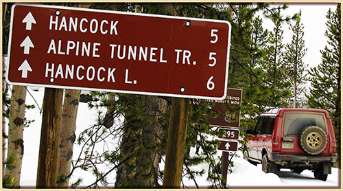


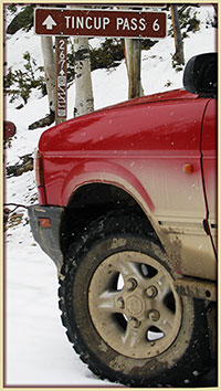 Review PREVIOUS YEARS trail status updates, dating back to 2001.