|
|
COVID-19 AWARENESS REMINDER: RECREATE RESPONSIBLY
DISPERSE AND ENJOY THE SOLITUDE.
Be a part of the Colorado High Country Pass user-based page.
CONTRIBUTE TRAIL STATUS UPDATES
HERE FOR 2020
CO High Country Pass Facebook!

The status of many popular high elevation
4x4 trails in Colorado are listed below and are updated as the trails open
or close and as trail users contribute. The list includes some 2 wheel drive access roads. The voluntary
trail-status updates come from many sources, primarily individual trail riders plus the National Forest Service and
the BLM.
As Colorado mountain weather
can be highly unpredictable, please check with the relevant information
body yourself for any recent changes. Conditions can change without
notice. It is also subjective - a trail one person says is open, may be
considered too dangerous to travel by another.
 Review PREVIOUS YEARS trail status updates, dating back to 2001.
2019 information,
2018 season,
2017 season,
2017 season,
2016 season,
2015 season,
2014 season,
2013 season,
2012 season,
2011 season,
2010 season,
2009 season, 2008 season,
2007 season,
2006 season,
2005 Season,
2004 Season,2003 Season, the 2002 Season or the 2001 Season.
This
list is intended as a guide only and no responsibility is taken for any
incident arising from mis-information. The ultimate responsibility as
to whether the trail is safe to travel, within the capabilities of
yourself and your vehicle, or indeed open at all, is taken by YOU. If
in doubt, DO NOT TRAVEL. The inclusion of any trail on this page does
not mean it is open or legal to travel. Conditions change, and trail
status may change, often without warning. Use common sense, and do
not go around closure barriers. YOU have responsibility for your own actions and all of these trails should be considered TRAVEL AT YOUR OWN RISK AND RESPONSIBILITY.
Want additional information on these trails?
Trail Damage is excellent for trail directions, descriptions, maps & ratings.
Need jeep parts and accessories? Try Partsgeek.com
REMEMBER - TREAD LIGHTLY
Got current current information on these or other trails that you would like to see included on this site?
Fill out trail status update form here. .
For notification of when this page changes, subscribe to our mailing list, at the bottom of this page.
Now on Twitter!
Jump straight to the trail you are interested in:
| TRAIL NAME |
NATIONAL FOREST NAME/ RANGER DISTRICT |
PHONE NUMBER |
STATUS |
DATE UPD. |
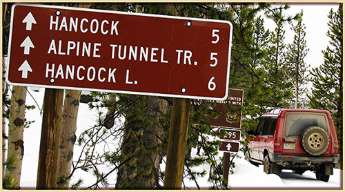
ALPINE TUNNEL
ROAD #839 |
Gunnison/Gunnison |
970-641-0471 |
OPEN
TO ROCK FALL |
7/3/20 |
COMMENTS: Courtesy of Gunnison Ranger District.
| 7/21/20
- Trail Open.
NOTE - The Palisade section of FSR 839 towards Alpine Tunnel remains closed (above junction of Tomichi Pass Trail FSR 888 ) until
further notice. See earlier update of 7/3/20.
7/3/20 - Courtesy of trail rider Kurt.
- West approach (from Pitkin)... Road is OPEN for about 6 miles (until the hairpin where Tomichi/Hancock Pass Road FSR 888, splits off)
and then the Alpine Tunnel Road is blockaded due to rock falls and a very serious collapse of the retaining wall supporting the road.
NOTE - The remaining 3 miles toward the west portal of the tunnel are walkable.
Rock fall location image as seen on Bushducks FB
from the Pallisades, some time back.
CLICK to SUBMIT
your trail-status update for Alpine Tunnel Road #839
|
| ALTA LAKES ROAD FSR 623 |
Uncompahgre GMUG
Norwood R District |
970-874-6600
970-327-426 |
OPEN |
7/7/20 |
COMMENTS:
| 7/7/20
- OPEN.
|
Animas Forks
CR 2
11,160 ft. |
Uncompahgre/Ouray
San Juan County |
970-240-5300 |
OPEN |
6/3/20 |
COMMENTS:
| 6/3/20
- San Juan NF Update: Remains Open.
5/28/20
- Per San Juan NF: Open. |
Argentine Pass/Waldorf Mine
FSR 724.1
Start 11,594 ft.
Pass 13,207 ft. |
White River NF Dillon R District |
970-468-5400 |
OPEN |
10/10/20 |
COMMENTS: Courtessy of trail rider Jerry :)
| 10/10/20
- Wow this trail is rocky.
Really nice day in the 60s, smoke wasn't bad.
Only one other guy in the lot at 8:30 but full by noon. Traffic on I-70 was a disaster going west at 1:00 for the late risers.
Big horn sheep and fall colors add to the joy of this ride right now.
Argentine trail & vista pics/photos on Bushducks CO PASS Facebook.
7/12/20 - Courtesy of Bilal.
- OPEN all the way.
No blockage all the way to the top of the pass. Trail is in great condition.
Note - Slightly overgrown brush in some areas. Expect some minor pin striping.
|
| Aspen Ridge (CR 175)/Bassam Park (CR 187) |
San Isabel |
719-486-0749 |
OPEN |
7/1/20 |
COMMENTS:
| 7/1/20
- Open. |
BALD MOUNTAIN TRAIL/ BALDY RD
FSR 520/520.1/.3
Jnt Boreas PassRd CR10 10,086 ft.
Iowa Mill 11,239.
Carbonate Mine 12,127 ft.
High point Upper Mt Baldy Road 12,575 ft. |
White River/
Dillon Ranger Dist
Summit County |
970-468-5400 |
CLOSED |
11/24/20 |
COMMENTS: Courtesy of Dillon Ranger District :)
| 11/24/20
- FSR #520/520.3/528.1b/528.2 CLOSED to all motor vehicles, mountain bikes
and e-bikes per Dillon Ranger District Update
6/15/20 - Courtesy of Matt.
- Gate is open.
Blocked by snowdrift across the trail at the highest switchback, start of Upper Mt Baldy Road FR 520.3.
Bald Mt Snowdrift Image at 11,874 ft.
Thanks for sharing, Matt.
There was enough room for me to turn around in an F150.
6/12/20
- Per Dillon Ranger District Update: Same status - OPEN.
Only Road FSR #520 open.
5/22/20
- White River NF Update. FSR #520 Open. |
BALLARD ROAD
FSR 129 |
Canyon Lake Ranger District |
970-295-6700 |
OPEN
SEE TRAVEL ADVICE |
6/6/20 |
COMMENTS:
| 6/6/20
- Per Canyon Lakes Ranger District: FSR 129 Open (snow may make road impassable) |
| Bangs Canyon |
BLM |
Grand Junction |
OPEN |
7/1/20 |
COMMENTS:
| 7/1/20 - OPEN |
BARBOUR FORKS
FSR 194.2
B Forks TH 8,490
Devils Spur T/H 10,482 ft. |
White River/Dillon
Pike/South Platte |
970-468-5400
303-275-5610 |
OPEN |
6/16/20 |
COMMENTS:
| 6/16/20
- Per Clear Creek Ranger District: NFSR 194 OPEN.
5/30/20
- This trail is closed. The gate is closed at the entry.
|
| Billings Canyon |
BLM |
Grand Junction |
OPEN |
6/20/20 |
COMMENTS:
| 6/20/20
- Open. |
Billings Lake/
North Fork S. Arkansas Road
CR 240.
Pride of the West Mine 12,011 ft.
Angel of Shavano
Camp 9,163 ft. |
Chaffee County/
Salida Ranger Dist |
719-539-4591
719-539-3591 |
OPEN |
6/15/20 |
COMMENTS:
| 6/15/20
- Open all the way to the mine, Pride of the West Mine, above Billings Lake.
No snow anywhere near the trail. It's probably been open for at
least 4 weeks, maybe 8 weeks.
|
BILL MOORE LAKE FSR 183.1
BM Lake 11,348ft
Jnct FSR 183.1C
11,118 ft. |
Arapaho NF /
Clear Creek R Dist |
970-295-6600
303-567-4382 |
OPEN |
6/23/20 |
COMMENTS: Courtesy of trail rider Nick.
| 6/23/20
Trail is open all the way!
Group of Jeeps bashed through the last snow bank at the very top.
Note - FSR 183.1C Bill Moore Vista Road, as the name implies, is a spur trail to a vista point overlooking the lake, at 11,405 ft.
Bill Moore Vista Point on FSR 183.1C. Yep!
|
| Birdseye Gulch |
Pike/South Park
Leadville County |
719-836-2031 |
|
|
COMMENTS:
| | |
BLACK BEAR PASS
FSR 648 &
FSR 823
BB Pass 12,840 ft |
Uncompahgre/Ouray |
970-327-4835 |
CLOSED |
10/14/20 |
COMMENTS: Per San Miguel County Sheriff Update
| 10/14/20
- Switchbacks temporarily blocked due to serious accident. Jeep cascades down Black Bear Pass switchbacks. Occupants thrown from rolling
vehicle & hospitalized.
Please consider donating to a fellow high country pass traveler now, and sadly for quite some period ahead, is in need of much assistance.
A Jeep further down the switchbacks, by pure chance of their active dashcam, recorded the horrid scene as it rolled out.
Their video is a frightening visual reminder to all choosing to travel these trails - it is a dangerous activity, please stay alert at all times. Your life is in your hands.
10/6/20 @ 6.25pm. - Per San Miguel County Sheriff.
BB Pass is now OPEN again.
Sadly, a newly wed couple, the only occupants in the light aircraft which crased east of Telluride, have passed away.
Condolences to their family and friends.
Note - Drone flying, as permitted, resumes.
San Miguel County Sheriff Facebook posting of the crash scene. Warning! - an upsetting scene.
10/6/20 @ 9am.
BB Pass CLOSED due to aircraft crash east of Telluride
Rescue aircraft operations underway.
Note - NO drone flying in the area.
7/28/20 - Per Ouray County Road & Bridge.
HIGH COUNTRY ROADS UPDATE: Black Bear Pass is now re-opened.
7/27/20 - Per Ouray County Road & Bridge.
- ALERT: Black Bear Pass is CLOSED until further notice on the Telluride side due to mudslides.
7/21/20- Courtesy of Steve N.
Yes, trail remains open all the way.
The steps are a bit more difficult this year from washout of dirt so more rock and a little off camber. Switchbacks a little tougher
but no big problems at all.
7/9/20 - Courtesy of Todd B. ---------------- OFFICIALLY OPEN AS of JULY 9, 2020.
- Black Bear Pass was opened today, all the way from Red Mountain Pass, US-550, thru to Telluride.
Freshly bulldozed from top of pass down to Bridal Veil Falls, so road surface is as good as it's going to get, with loose rocks
pushed off.
A credit to San Miguel Co. Road & Bridge crew who pushed on thru the switchbacks once again and released much of the loose
rocks to open this classic trail.
7/9/20 - Courtesy of San Miguel CO. Road & Bridge crew!
- It's official..... as of July 9, 2020, BLACK BEAR PASS is OPEN!
San Miguel County Road & Bridge crew totally rock!
REMINDER - as with any bear, respect is the case. This particular Black Bear deserves massive respect. Stay safe on this cliff hanger of a trail.
Check on over at Bushducks Black Bear FB update.
7/7/20 - Courtesy of San Miguel Co. Road & Bridge
NOTE - There is no access to Bridal Veil Falls on THURSDAY JULY 9, 2020
No vehicles, hikers or bikers allowed. The San Miguel County Road crew will be coming off of the switchbacks on Black Bear Pass
creating dangerous conditions for anyone below the road.
OPEN date? All going well on the switchbacks, this weekend July 11/12, 2020.
Check back here, or follow Busducks FB.
6/3/20
- Still closed, snowed in, per National Forest Service.
Historically, Black Bear Pass can open by late June, July and even later.
See Bushducks Black Bear Pass status for 2019
Compared to Bushducks Black Bear Pass status for 2018
A decade earlier Bushducks Black Bear Pass 2008 |
BLACKTAIL CREEK/ RADIUM ROAD
FSR 212.1 |
Routt Nat Forest
Yampa R District |
307-745-2300
970-638-4516 |
OPEN |
7/15/20 |
COMMENTS:
| | 7/15/20 - OPEN. |
BLOWOUT PASS /
East Fork Pinos Road FR 329 /
Spring Creek Road 280 /
Dry Creek Tr#700
B. Pass 11,774 ft. |
Rio Grande/Divide |
|
OPEN |
5/24/20 |
COMMENTS:
| 5/24/20
- Open all the way. |
| BOLAM PASS/ HERMOSA PARK ROAD FSR 578 |
Uncompahgre/Ouray |
970-240-5300 |
OPEN |
6/26/20 |
COMMENTS: Courtesy of San Juan National Forest.
| 6/26/20
- Trail OPEN from the Purgatory, East side.
6/3/20
- Still Closed per Nat Forest.
5/23/20
- Open to greysill mine from the purgatory side.
Dry most of the way with two landslides that can be driven around without issue. |
BOREAS PASS
Summit Co CR 10
Park County CR 33
Jnct Bald Mt Rd FSR 520 10,086ft
B. Pass 11,482 ft.
Como Cem 9,923ft |
White River/
Dillon Ranger Dist
Summit County
& Park County |
970-468-5400 |
CLOSED |
11/24/20 |
COMMENTS: Courtesy of trail rider Dave & Dillon Ranger District :)
| 11/24/20
- Boreas Pass - County Road 10 CLOSED to all motor vehicles, mountain bikes
and e-bikes per Dillon Ranger District update.
8/3/20 - Courtesy of trail driver Rich B.
- Started in Breckenridge and ended up in Como.
Trail is OPEN all the way without any problem spots. Seemed to me that the initial part right after the end of pavement has smoothed
out greatly vs what it has been in the past.
On the north side, lots of people camping alongside the road in various places, so watch out for them. Not so much on the south side.
Trail popularity - Traffic was light today.
7/6/20
- Per Dillon Ranger District latest Update - OPEN Status.
NOTE Although classed as OPEN, allow for issues on the south side until further updates.
6/18/20
- Open now to the pass from Breckenridge. (Not sure south side.)
Road dry up to the pass.
6/15/20
- Breckenridge gate was still closed 6/15/20.
Mountain biked to the top, dry the whole way, no snow or mud on the Breck side.
6/7/20
- Gate closed on the Breckenridge side and on top. There was a vehicle on the Como, Park County side, guessing Como side CR 33 is open.
6/4/20
- Per Dillon Ranger District Update: Still closed, snowed in for now.
5/22/20
- White River NF, Dillon Ranger District Update: CR 10 Closed. Summit County maintained road. No ATVs or unlicensed vehicles. Snowy and muddy. |
BREAKNECK & BROWNS PASSES
FSR 175 & 176
BK Pass 10,914 ft.
Browns Pass 11,374 ft. |
Pike/Fairplay |
719-836-2031 |
OPEN |
6/13/20 |
COMMENTS: Courtesy of Glenn
| 6/13/20
- Per Mile High Jeep Club Patrol 2: Open all the way!
Opened by Mile Hi Jeep Club Patrol 2 Adopt a trail.
Trees blocking the trail have been removed.
No more snow. Clear all the way on all off shoot trails as well.
PLEASE NOTE - Stay RIGHT after the water crossing, keep ATVS out of the drainage wash on
the left side going up to TWELVEMILE LAKE area on FSR 173!
|
| Browns Gulch |
Uncompahgre/Ouray |
970-327-4835 |
|
|
COMMENTS:
| | |
BULL PARK ROAD
FSR 376.A |
Pikes Peak Ranger Dist |
719-636-1602 |
OPEN |
8/15/20 |
COMMENTS: Courtesy of trail driver Sam G.
BULL PARK TRAIL is OPEN all the way to the end. We have driven this trail twice this season.
Reminder sign at gate: ROAD CLOSED FROM DEC. 1 TO MAY 31.
Note - Bull Park Trail is more difficult this year due to erosion. Trail drivers may need a lifted vehicle to get over the rocks on the trail.
|
Bunce School Trail System
FSR 115 & FSR 105
FSR 202 & FSR 203 |
Boulder |
303-541-2500 |
OPEN |
6/4/20 |
COMMENTS: Courtesy of Kris
| 6/4/20
- Open. |
CALAMITY MESA
BLM 867/ 875/ 877 |
BLM Grand Junction |
(970) 244-3000 |
OPEN |
7/5/20 |
COMMENTS:
| | 7/5/20 - OPEN. |
CALIFORNIA GULCH
CR 9 & CR 19.
Animas Forks Junct CR9 & CR2
10,998 ft.
Frisco Mill/ Bagley Tunnel 11,438 ft. |
Uncompahgre/Ouray |
970-240-5300 |
OPEN |
6/20/20 |
COMMENTS:
| 6/20/20
- Californai Gulch trail is open all the way.
Trail is wet, snow free, but there is runoff moving along the trail in California Gulch, on the east approach to California Pass.
|
CALIFORNIA PASS
CR 19
Mountain Queen Mine 12,781 ft.
C. Pass 12,960 ft. |
Uncompahgre/Ouray
San Juan County |
970-240-5300 |
OPEN |
6/20/20 |
COMMENTS:
| 6/20/20
- Trail is open all the way.
Wet trail, snow free, but runoff moving down trail CR 19 on California Gulch side, east side of California Pass.
6/3/20
- Remains closed, snowed in, for now per Nat Forest Service. |
Caribou Creek
FSR 505.1,
CR 116J, CR 128J |
Arapho-Roosevelt/ Boulder Ranger Dist |
970-295-6600
303-541-2500 |
OPEN |
6/22/20 |
COMMENTS: Per Boulder Ranger District.
| 6/22/20
Caribou at Eldora, NFSR 505, CR 128J, OPEN.
Caribou at Rainbow Lakes Road, NFSR 505, CR 116J, OPEN.
Caribou Townsite North, NFSR 505, CR 116J, OPEN.
Caribou Townsite West, NFSR 505, CR 128J, OPEN.
6/16/20
- Per Boulder Ranger District latest update:
Caribou at Eldora, NFSR 505, CR 128J Status: CLOSED.
Caribou at Rainbow Lakes Road, NFSR 505, CR 116J Status: CLOSED.
Caribou Townsite North, NFSR 505, CR 116J Status: CLOSED.
Caribou Townsite West, NFSR 505, CR 128J Status: CLOSED.
5/7/20
- Per Boulder Ranger District: Closed. |
Carnage Canyon
(Buena Vista) |
San Isabel/Salida |
719-539-3591 |
OPEN |
6/20/20 |
COMMENTS:
| 6/20/20
- OPEN. |
CASCADE CREEK/CREST ROAD
Clear Creek CR 116 & FSR 710.1 |
Clear Creek Ranger
Idaho Springs Visitor Center |
303-567-3000
303-567-4382 |
OPEN |
6/6/20 |
COMMENTS:
| | 6/6/20 - Yes the trail is open all the way.
At the top we ran up to the top of Saxon Mountain on Saxon Summit Road FR 712.2C.
It was VERY busy.
|
| CEMENT CREEK ROAD FSR 7740 |
Gunnison/Gunnison |
970-641-0471 |
OPEN |
7/27/20 |
COMMENTS: Courtesy of trail driver Bart C.
| 7/27/20
- OPEN all the way to the top.
Overall the trail is in good shape with all the normal mud puddles and rocky areas.
The ascent to top has a long erosion rut down the middle of the road from about the first to second turns.
Easily straddled but one of our drivers got too far right and high-centered between the rut and the outer edge of the road.
Keep the rut between your wheels and youre fine.
Several of the switchbacks have been flattened down and dirt put in the low areas to flatten out the turn.
Easy to get around the turns in a 4-door and nothing new about the run.
|
| Chalk Mountain |
White River/Holy Cross |
970-827-5715 |
|
|
COMMENTS:
| | |
CHIHUAHUA GULCH
FSR 263 |
White River/Dillon |
970-468-5400 |
OPEN |
8/1/20 |
COMMENTS: Courtesy of trail driver Daegan O.
| 8/1/20
- Road is open all the way to Chihuahua Lake Trailhead.
Trail in usual condition. Plenty of water in the crossings as you'd expect at this time of the year.
See aerial view of Chihuahua Gulch at Bushducks Facebook
|
CHINAMAN GULCH
BLM 6044 |
San Isabel/Salida |
719-539-3591 |
OPEN |
6/24/20 |
COMMENTS: Courtesy of Steve Burt
| 6/24/20
Open for fun...... for quite some time.
Love them or loath them?!
Go check out Steve's video of the new kid on the block assaulting Chinaman Gulch.
|
CHINA WALL / BOX ROAD.
FSR 212 /FSR 204
Junct FSR 212 &
CR-77 8,772 ft.
China Wall crest 9,010 ft. |
Pike NF/
South Park R. Dist
Park County |
719-836-2031 |
OPEN |
6/15/20 |
COMMENTS:
| 6/15/20
- Seasonal gate closure is OPEN as of 6-15-20.
5/8/20
- Trail gate closed with sign that says closed until June 15.
|
Chinns Lake
FSR 174.1D
Chinns Lake 11,052 ft.
Junct FSR 174 10,405 ft. |
Clear Creek R. Dist
Clear Creek County |
303-567-3000 |
PARTIAL |
6/17/20 |
COMMENTS:
| 6/17/20
- Almost got to the top, 150 yards away from first lake, Chinns Lake.
Snow blocking the trail 150 yards from the first lake right at the last turn,
left onto FSR 174.1D, where Rainbow Road FSR 174 continues ahead to Fall River Reservoir.
Probably be a few more weeks till FSR 174.1D is fully open to both Chinns and Sherwin Lake.
|
Cinnamon Gulch
FSR 262 |
White River/Dillon |
970-468-5400 |
AWAITING UPDATE.
Been/going there?
Happy to share? |
|
COMMENTS: NONE YET :(
| CLICK to SUBMIT your trail-status update.
Images? Easy, email Bushducks :) |
CINNAMON PASS
San Juan CR 5
Hinsdale CR 30
Pass 12,640 ft. |
Uncompahgre/Ouray
BLM/Gunnison |
970-240-5300
970-641-0471 |
OPEN |
9/2/20 |
COMMENTS: Courtesy of trail rider Jerry :)
| 9/2/20
- Rode the entire loop. Road was in great condition, breathtaking views.
Not as crowded as I would have expected. Smoke haze from California and Colorado fires was not too bad.
Fall colors showing signs but not really going yet. Predicted snow on the 8th could change all that.
6/1/20
- Open all the way.
5/28/20
- Per NF: Open to Lake City.
|
CLEAR LAKE
FSR 815 |
Uncompahgre/Ouray
San Juan County |
970-240-5300 |
PARTIAL |
6/26/20 |
COMMENTS: Courtesy of San Juan National Forest
| 6/26/20
- Trail OPEN to waterfall. Clear Creek Waterfalls.
6/3/20
- Remains closed, snowed in, for now per San Juan National Forest.
|
CONEY FLATS
FSR 507.1
Beaver Reservoir Rd CR96 9,082 ft
Coney Flats T/H & Coney Creek crossing 9,781 ft.
Junct Middle St. Vrain Road
FSR 114.1
9,604 ft. |
Arapho-Roosevelt/ Boulder Ranger Dist |
970-295-6600
303-541-2500 |
OPEN |
6/20/20 |
COMMENTS:
| 6/20/20
- Per USFS Boulder Ranger District: Coney Flats is OPEN all the way.
Trailridge Runners 4WD Club ran the road. Downed trees have been removed and drainage repaired. Bypass routes have been blocked.
NOTE - Water levels at crossings are high with spring run off right now.
6/15/20
- Per Boulder Ranger District latest update: FSR 507 Still CLOSED.
5/7/20
- Per Boulder Ranger District: Closed. |
| Coon Hollow |
BLM Grand Junction |
303-239-3600 |
|
|
COMMENTS:
| |
CORKSCREW GULCH / PASS FSR 886 &
San Juan CR 11 |
Uncompahgre/Ouray
BLM/Gunnison |
970-240-5300
970-641-0471 |
CLOSED |
10/27/20 |
COMMENTS: Courtesy of Ouray County Road & Bridge.
| 10/27/20
- Trail will receive no further maintenance for the winter season after November 1st. Snow and icy conditions may exist now, or at any time after maintenance has ceased.
Ouray County R&B update on Bushducks Hi Country Pass Facebook
6/26/20 - Courtesy of San Juan National Forest.
Corkscrew Pass - Still OPEN. Washouts near the top making it narrow.
6/8/20
- Per Ouray County: Corkscrew remains open.
6/1/20
- Open all the way. |
COTTONWOOD PASS
FSR 209/FSR 306
12,126 ft. |
San Isabel/Salida
Gunnison County |
719-539-3591
970-641-0044 |
CLOSED FOR 2020 |
11/13/20 |
COMMENTS: Courtesy of Shawn F :)
| 11/13/20
Pass is officially marked by state sign as CLOSED due to snow.
10/15/20 - Courtesy of Aspen-Sophris Ranger District Update :)
- Cottonwood Pass Road is only open to ESSENTIAL travel at this time.
9/16/20 - Courtesy of Brett A.
- Pass is OPEN in both directions.
Trail condition: Dry and good.
9/8/20 Per Gunnison County Announcement
Effective 9/8/20 at 4:15 pm Cottonwood Pass on both the Chaffee County and Gunnison County sides is CLOSED
until further notice to do adverse weather and unsafe road conditions.
Questions 970-641-0044.
6/9/20
- Per Gunnison County: Snow storm in the area of Cottonwood Pass last night (6/8/20).
Although Cottonwood Pass remains open we are not advising travel today 6/9/20 due to snow, ice and drifting on the road.
5/26/20
- Per Gunnison County announcement: Cottonwood Pass will open tomorrow morning (5/27/2020) at 8:00 am.
Please expect wet and possibly icy road conditions.
Note - Opened officially 27 May 2020.
5/26/20
- Gunnison County Public Works said there is a target date set to open the pass June 1.
|
Crooked Creek
FSR 194 / 669 |
Pike/South Park |
719-836-2031 |
AWAITING UPDATE.
Been there?
Going there?
Happy to share? |
|
COMMENTS: NONE YET :(
| CLICK to SUBMIT your trail-status update.
Images? Easy, email Bushducks :) |
CUMBERLAND GULCH
FSR 271.1D |
Clear Creek |
303-567-3000 |
OPEN |
6/2/20 |
COMMENTS:
| 6/2/20
- Traveled 271.1D.
Yankee Hill area opening up. Nearby trails 772.1 Mosquito Ck/Yankee Hill north approach trail and 709.1 Miner's Gulch still had snow drifts about half way up (cooler/shaded side of the mountain).
|
CUMBERLAND PASS FSR 7765
C Pass 12,021 ft. |
Gunnison Nat Forest
Gunnison R District
Gunnison County |
970-641-0471
970-641-0044 |
OPEN |
6/11/20 |
COMMENTS:
| 6/11/20
- All dry and clear of snow except for a 1/4 mile stretch maybe 1/2
mile north of the summit. A large snow field probably was blocking the road
a week or so ago and still covers about half the road. So a bit narrow for
a little ways. The wheel ruts in the snow have reached to the gravel, with
maybe 6" of soft snow between the ruts.
|
CUNNINGHAM GULCH
San Juan CR 3
Stony Pass 12,650 |
Uncompahgre/Ouray |
970-240-5300 |
OPEN |
6/1/20 |
COMMENTS:
| 6/1/20
- Open all the way.
5/28/20
- Per San Juan SF: Open to about a mile past Stony Pass. |
Dakan Mountain Road
FSR 563 |
Pike/Fairplay
South Platte Ranger Dist |
719-836-2031
303-275-5610 |
OPEN |
11/18/20 |
COMMENTS: Courtesy of anonymous Rider contributor
11/18/20
- Dakan Road is still open. Not enough snow to mention.
Rode all the way to Rainbow Falls. Only a few icy spots on the Rainbow Falls side of Rampart Range Road FSR 300.
Hit some side trails and no problems.
Went up to see if it was still open on Sunday the 15th and the big lot was almost full!
Today 11/18, only a few cars and riders. Some other vehicles but possibly hunters.
NOTE - Trail access Closes for the season on November 30th.
I'm not sure what gate that will be.
|
DEER CREEK /
MONTEZUMA DEER CREEK ROAD CR 5
Junct Webster Pass Rd 10,525 ft
Teller Mountain 12,602 ft |
White River/Dillon
Park County |
970-468-5400 |
OPEN
for over-snow vehicles |
11/24/20 |
COMMENTS: Courtesy of Dillon Ranger District :)
| 11/24/20
- FSR #5 OPEN to over snow vehicles with a state registration.
9/19/20 - Courtesy of Scott D.
- Trail remains OPEN, yep, wide open with no lingering effects from the snow storm earlier this month.
- 6/19/20
- Per Dillon Ranger District latest update; OPEN - allow for weather conditions.
ATVs and unlicensed motorcycles allowed with permit.
6/5/20
- Per USFS Dillon Ranger district and sign heading in to Montezuma this trail is still closed due to snow.
6/4/20
- Per Dillon Ranger District Update: CLOSED. Still too much snow.
|
| Democrat Mountain |
Arapaho/Clear Creek |
303-567-3000 |
|
|
COMMENTS:
| |
bushducks facebook image
|
DEVIL'S CANYON
FSR 246
Squaw Pass Road
Hwy103 9,895 ft
Devils Canyon TH 10,441 ft. |
White River/Dillon
Pike/South Platte |
970-468-5400
303-275-5610 |
OPEN |
6/27/20 |
COMMENTS: Courtesy of Scott.
| 6/27/20
Completely OPEN.
Good condition throughout. The one steep, difficult spot seems a little easier this year - maybe a little wider, allowing you to avoid
the large step. Lots of nice dispersed campsites, but very few spots taken for a Saturday.
The Clear Creek County fire ban must be keeping the campers in developed campgrounds. Lots of day trippers, though, mostly 4x4s and
dirt bikes.
6/16/20
- Per Clear Creek Ranger District Update: FSR 246 OPEN. |
| Dolores Point |
BLM |
Grand Junction |
|
|
COMMENTS:
| | |
| Eagle Rock |
Teller County |
Near Colorado Springs |
OPEN |
5/16/20 |
COMMENTS:
| |
5/16/20 - The trail is open all the way. No snow. A little mud but very
passable. One of the first to open up in 2020. The trail is not closed due to Covid.
|
| Eldorado Mountain |
Boulder |
303�541-2500 |
|
|
COMMENTS:
| | |
Elwood Pass /
East Fork Rd
FSR 667 &
FSR 380
E Pass 11,650 ft. |
Rio Grande/Conejos
San Juan/Pagosa |
719-274-8971
970-264-2268 |
OPEN |
6/10/20 |
COMMENTS:
| 6/10/20
- Per Rio Grande Nat Park Update: FSR 380 OPEN.
FSR 330, Park Creek Rd, is the eastern approach to Elwood Pass.
Awaiting status up on FSR 667, East Fork Road, the western approach to Elwood Pass.
5/24/20
- We made it all the way through to the top. There was some lingering snow drifts and some very slippery mud at the top
from the melting snow, but we were able to get through.
There was a huge snow drift over FSR 380 just West of the end of the Elwood Pass trail preventing travel in that
direction. It will probably be a couple weeks before that drift melts.
|
ENGINEER PASS
San Juan CR 2 / Hinsdale CR 20
Lake City 8,680 ft. Pass 12,790 ft. Animas Forks 11,200 ft. |
Uncompahgre/Ouray
BLM/Gunnison |
970-240-5300
970-641-0471 |
CLOSED |
11/23/20 |
COMMENTS: SNOFLO
| 11/23/20
- Snowpack level recorded at 18".
Equates to -24% below average for this time of the year.
10/27/20
Trail will receive no further maintenance for the winter season after November 1st. Snow and icy conditions may exist now, or at any time after maintenance has ceased.
Ouray County R&B update on Bushducks Hi Country Pass Facebook.
10/26/20 - Courtesy of George W. :)
- Engineer Pass partially blocked Oct 19, 2020 by a 30 ft box van .
Debates on recovery methods hampered by current snow.
9/2/20 - Courtesy of trail rider Jerry
- Rode the entire Alpine Loop from Lake City. Road was in great condition.
Breathtaking views. Not as crowded as I would have expected.
Smoke haze from California and Colorado fires was not too bad.
Fall colors showing signs but not really going yet. Predicted snow on the 8th could change all that.
6/8/20
- Per Ouray County: Engineer Pass: Open.
6/7/20
- Open Lake City to Animas Forks. Normal condition, occasional water spots of a few inches.
6/3/20
- Per National Forest: (Lower end to 550) - Closed.
5/30/20
- Open to top from Ouray. Don't know about Lake City.
5/28/20
- Per San Juan NF:
Open to Lake City. Per San Juan NF: Lower end to 550 closed.
|
EUREKA GULCH
San Juan CR 25 |
Uncompahgre/Ouray
San Juan County |
970-240-5300 |
OPEN |
6/26/20 |
COMMENTS: Courtesy of San Juan National Forest
| 6/26/20
- OPEN.
6/3/20
- Still closed, snowed in, per National Forest Service. |
| FOURMILE TRAVEL AREA |
San Isabel/Salida |
719-486-0749
719-539-3591 |
OPEN |
6/30/20 |
COMMENTS:
| 6/30/20
OPEN |
Garibaldi Gulch Rd
FSR 356.1
Junct FSR 354.1 10,552 ft.
Wise Mt. Cabin 12,054 ft.
Junct FSR 275.1 12,517 ft. |
White River/Dillon |
970-468-5400 |
AWAITING UPDATE.
Been there?
Going there?
Happy to share? |
|
COMMENTS: NONE YET :(
| CLICK to SUBMIT your trail-status update.
Images? Easy, email Bushducks :) |
GENEVA CREEK
FSR 119
Geneva Rd 9,722 ft.
Geneva Lake 10,989 ft
Sill Mine 11,808 ft. |
White River/Dillon
Pike/South Platte
Park County &
Clear Creek Co.
|
970-468-5400
303-275-5610 |
OPEN |
6/27/20 |
COMMENTS: Courtesy of Glenn.
| 6/27/20
- OPEN all the way!
Bashed through last snowdrift on the way to the Sill mine. Trail ends near Geneva Lake and structures below the Britannic Mine.
PLEASE NOTE - Final 1/4 mile to Sill mine is CLOSED permanently. There is no gate blockade, yet there is a sign.
Please DO NOT drive up to the mine. Simply enjoy the hike to 11,808 ft.
6/6/20
- Open up to the fork by the small lake at 11,600 ft. Snow blocked after that.
Trail in good shape, no noticeable washouts. Few fallen trees have been cut to open the trail.
|
GEORGIA PASS
South Fork Swan FSR 355
G Pass 11,585 ft. |
White River/Dillon |
970-468-5400 |
OPEN
for over snow vehicles |
11/24/20 |
COMMENTS: Courtesy of Dillon Ranger District.
| 11/24/20
- Georgia Pass (South Fork Swan) - FSR #355 Open to over snow vehicles with a state registration.
6/28/20 - Courtesy of Derek.
- Open all the way from Tiger Road, Summit County Rd CR 6, up to the top and down the south
side into Jefferson.
Georgia Pass North face update at Bushducks
Facebook Update.
Note - Only saw very small patches of snow off in the trees. Saw no snow
on top, it was dry. Water from snow melt was running down the rocky chute
about 3/4 mile from the top on the North side.
6/27/20 Courtesy of Bret.
- Open all the way.
Georgia Pass - Birds Eye View at
11,585 ft. opened 6/27/20.
Clear road all the way from Jefferson to the top of the pass.
From the top down towards Breckenridge, the beginning is very rocky and in spots deeply rutted.
- Bret's dashcam
- Slower going once north of the pass, snow melt has exposed rocks.
A good portion of this upper section is now a flowing stream until you reach the bottom of the valley. From that point it is just fine.
6/17/20
- Per Dillon Ranger District: Still Closed due to snow.
Correction to previous "Open" status, the trail is NOT open to the top.
The gate below is indeed open, which is why the Dillon Ranger District calls the trail "Open".
However, they sent a ranger up there today to check it out and there's still too much snow at the top.
6/4/20
- Per Dillon Ranger District Update: FSR 355 Open. |
| Gold Hill/Switzerland Trail |
Boulder |
303-541-2500 |
|
|
COMMENTS:
| | |
Goose Creek Road
CR211 |
Pike/Fairplay |
719-836-2031 |
AWAITING UPDATE.
Been there?
Going there?
Happy to share? |
|
COMMENTS: NONE YET :(
| SUBMIT your trail-status update.
Images? Easy email Bushducks :) |
| Gordon Gulch |
Roosevelt National Forest |
970-498-1100 |
|
|
COMMENTS:
| | |
| GOVERNOR BASIN FSR 853 |
Uncompahgre/Ouray |
970-240-5300
970 |
CLOSED |
10/27/20 |
COMMENTS: Courtesy of Ouray County Road & Bridge
| 10/27/20
- Trail will receive no further maintenance for the winter season after November 1st. Snow and icy conditions may exist now, or at any time after maintenance has ceased.
Ouray County R&B update on Bushducks Hi Country Pass Facebook
7/7/20
- OPEN to the top!
6/18/20
- Per Latest Ouray County Update: Still Closed by nature.
6/8/20
- Per Ouray County Update: Closed - Clearing by nature only. |
| Granite Creek Canyon |
BLM |
|
|
|
COMMENTS:
| | |
Green Ridge Road
FSR 177 & 399.
From Lost Lake
CR 103 to CR 86 |
Araphoe Roosevelt/
Canyon Lakes R Dist
Larimer County |
970-498-1100
970-295-6700
970-498-5650 |
Closed - YET......
AWAITING UPDATE.
Been there?
Going there?
Happy to share? |
6/16/20 |
COMMENTS: Awaiting Update Comments!
| SUBMIT your trail-status update.
Images? Easy, email Bushducks :)
6/16/20
- Per Canyon Lakes Ranger Distraict latest update: FSR 177 & 319 Still CLOSED.
6/6/20
- Per Canyon Lakes Ranger District: Closed. |
GREER ROAD
FSR 154 |
Roosevelt National Forest |
970-498-1100 |
OPEN
See Travel Adise |
7/13/20 |
COMMENTS:
| 7/13/20
- Per Canyon Lakes Ranger District Update: Once Again - Open (snow may make road impassable.)
6/6/20 - Per Canyon Lakes Ranger District Update: Open (snow may make road impassable.)
Note FSR 154 - Accessed from the Buckhorn Road, CR 44H, east of Pennock Pass. |
Grizzly Lake /
Grizzly Gulch 4WD Rd
FSR 296 |
San Isabel/Salida |
719-539-3591
|
OPEN |
|
COMMENTS:
| | - OPEN. |
GUANELLA PASS
CR 62 / FSR 381
Duck Lake 11,112ft
G. Pass 11,669 ft. |
White River/Dillon
Pike/South Platte.
Clear Creek County
Park County |
970-468-5400
303-275-5610 |
CLOSED |
10/24/20 |
COMMENTS: Courtesy of Park County Sheriff's Office
| 10/24/20
- Guanella Pass CLOSES early for 2020, due to high fire danger levels in Arapaho National Forest.
NOTE - Arapaho & Roosevelt National Forests CLOSED due to current extreme fire danger, as of Oct 23, 2020.
6/16/20
- Per Clear Creek Ranger District latest update: OPEN. |
| Gunsight Pass |
White River/Sopris District |
970-963-2266 |
|
|
COMMENTS:
| | |
HACKETT GULCH
FSR 220
High Pt 8,890 ft. |
Pike National Forest |
Near Colorado Springs |
OPEN |
5/24/20 |
COMMENTS:
| | 5/24/20 - Open all the way to the river on both forks.
Sandy trail. Dusty when dry. Muddy when wet.
|
HAGERMAN PASS
FR 105 /FR 105.1
Lake I. 10,909 ft
H. Pass 11,925 ft
Carlton Tunnel east portal 10,795
Turquoise Lake
9,869 ft. |
San Isabel/Leadville
White River/Sopris |
719-486-0749
970-963-2266 |
OPEN
Vehicle Restrictions Apply!
First Opened 7/3/20 |
8/23/20 |
COMMENTS: Courtesy of trail riders Scott W. & Adventure Riders of Colorado Chris A. :)
| 8/23/20
- Hagerman OPEN again.
We just did the BDR over Hagerman Pass and over to Eagle.
NOTE - Sign says NO passenger cars!
WILDFIRE ALERT! Fire danger remains EXTREME in this Leadville Region.
As of 8/21/20: Stage 1 Fire Restrictions in place, until recinded.
8/21/20 - Courtesy of trail rider Scott W.
- Hagerman CLOSED.
7/11/20 - Courtesy of trail rider Fred.
- Totally dry at the Pass.
Fred's screenshot near the pass on Bushducks FB.
7/6/20 Courtesy of trail driver John
- I called the Aspen-Sopris Ranger District this morning, and they confirmed Hagerman Pass is OPEN! Yeyy, the 83rd trail to open for 2020.
Our thanks go out to Lake County Road & Bridge Department who pushed on through for all to enjoy by the 4th!
A sign of the times.... :)
6/27/20 - Courtesy of trail rider John.
Still CLOSED on West side.
6/26/20 - Courtesy of trail rider Jason.
- Gate still CLOSED on the Frying Pan side at the fork to Ivanhoe, which is just part the Lyle Lake trailhead.
Frying Pan/Basalt side is dry and great condition to the gate.
Ivanhoe road to Betty Bear hut also dry and some sections above Ivanhoe look recently graded.
6/20/20
- Coming from the East from Leadville on FSR 105 Hagerman Pass Road - large snow bank at 11, 649 ft., at coordinates
N39, 15.944' W106, 27.985' a short distance up the trail from Skinner Hut.
Snow bank is not passable at all, even on 2 wheels!
6/14/20
- West approach to Hagerman Pass coming from Basalt on Frying Pan Road FR 532.1: OPEN TO LAKE IVANHOE.
The gate to FR 105.1, the road up to Hagerman Pass above, is locked.
The spur road to the west entrance of the Hagerman Tunnel, Ivanhoe Lake Road FR 527.1, is also closed.
Frying Pan Road FR 532.1 condition: Largely dry, with a small amount of water just below the Ivanhoe fork.
|
HALFMOON CREEK/GULCH
FSR 110 |
San Isabel/Leadville |
719-486-0749 |
PARTIAL |
7/14/20 |
COMMENTS: Courtesy of Christopher
| 7/14/20
Trail Open part of the way.
Blocked with snow at two points on the way to Champion Mine. Very high up. Open to Champion Mill.
Snow blocking road to Champion Mine about 2/3 in.
NOTE - Please respect the road is closed due to snow, unless you want to dig a lot of snow, and stay the trail.
We walked to near start of shelf road to the mine and encountered another deep snowfield.
Birds eye view of top end of Halfmoon Trail.
|
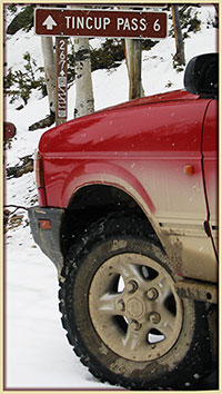
HANCOCK PASS
FSR 295,299,839
St Elmo 10,010 ft
H. Pass 12,140 ft Woodstock 11,025 |
San Isabel/Salida |
719-539-3591 |
OPEN |
9/2/20 |
COMMENTS: Courtesy of trail drivers Steve & Ellen N. :)
| 9/2/20
Trail remains OPEN all the way.
Trail is in good condition.
We traveled this after completing Tomichi pass and headed up Hancock from that direction.
We did not consider this trail a Red trail, but more high moderate. Lockers not needed, low gear helpful
but not a must and you can pick a line around areas with bigger rocks.
Stock Jeeps will hit bottom in certain areas.
Little if any water running down the trail.
7/29/20 - Per trail driver Ruth C.
- Trail is OPEN all the way!
Not much water flowing through at this point. We drove from Nathrop to Pitkin.
NOTE: We drove this pass 3 years ago in July. We can see why the trail has now been upgraded to "Red".
Due to trail use and erosion, embedded and loose rocks are more exposed and higher clearance vehicles are DEFINITELY needed.
Trail is still a lot of fun - we rated it a light red.
We drove 7 Jeeps over the pass, including a stock JL Rubicon, which scraped a couple of times :(
Careful tire placement and low gearing a must on this trail.
Have fun! .....another must :)
6/7/20
- Not open from St Elmo. You can get to tree line before being stopped by large snow field. Looks to be melting fast though.
Normal conditions on rest of trail.
|
HAYDEN PASS
FR 970 |
Rio Grande/Saguache
San Isabel/Salida |
719-655-2547
719-539-3591 |
OPEN |
6/7/20 |
COMMENTS: SUBMIT further trail-status update for HAYDEN PASS.
| 6/7/20
Open all the way.
Beware soft edge on shelf road near where pickup went down a
decade ago.
|
| Heart Lake Road FSR 518.1B & Carson Road FSR 518 & 7568 |
Rio Grande
Divide |
719-655-2547 |
AWAITING UPDATE.
Been there?
Going there?
Happy to share trail-status? |
|
COMMENTS: NONE YET :(
| SUBMIT your trail-status update.
Images? Easy, email Bushducks :) |
| HERMIT PASS/ LAKE ROAD FSR 160 |
Rio Grande/Saguache
San Isabel/San Carlos |
719-655-2547
719-269-8500 |
OPEN |
8/22/20 |
COMMENTS: Courtesy of Trail Driver Simon E.
| 8/22/20
- Trail is CLEAR all the way to the top.
Surface is rocky as always, but worth the trip! |
| Hidden Valley Trail |
Pike/South Platte |
303-275-5610 |
|
|
COMMENTS:
| | |
Holy Cross City FSR 759
Start 9,360 ft
End 11,450 ft. |
San Isabel/Holy Cross |
970-827-5715 |
Closed |
5/21/20 |
COMMENTS: Courtesy of Eagle-Holy Cross Ranger District
| 7/8/20
- No change of status. Exact same update as last NF update of 5/21/20.
5/21/20
- White River NF Update, Snow-packed as of 5/21/20 - access depending on FSR 704 and 727.
Usually passable mid-June, high water crossings. |
HURRICANE PASS/PEAK
12,730 ft. |
Uncompahgre/Ouray |
970-240-5300 |
OPEN |
5/28/20 |
COMMENTS:
| | 5/28/20 - Per San Juan NF: Open to top. |
IMOGENE PASS
CR K68/
FSR #869/CR 26A
Telluride 8,875 ft
I PASS 13,114 ft
Junct I Pass Rd & CR26A 11,242 ft. |
Uncompahgre/Ouray |
970-327-4835 |
CLOSED |
9/14/20 |
COMMENTS: Courtesy of San Miguel County Road & Bridge.
| 11/9/20
- All County High Country Passes are CLOSED for the Winter.
See you next Summer!
9/14/20 - Courtesy of San Miguel Co Road & Bridge
Imogene Pass has now RE-OPENED.
This follows the delayed completion of bridge repair work hampered by recent snow storm.
Check out their snow-covered repair works on San Miguel R&B Facebook
7/28/20 - Per Ouray County Road & Bridge.
- HIGH COUNTRY ROADS UPDATE: Imogene Pass is now OPEN in both directions. This follows the clearing of mudslides on Telluride side.
7/27/20 - Per Ouray County Road & Bridge.
- ALERT: Imogene Pass is CLOSED until further notice on the Telluride side due to mudslides.
7/21/20 - Per trail dirvers Steve & Ellen N.
- Trail is completely open but the traffic on this day was ridiculous. At least 30 vehicles had to pull over and wait for our group
of 9 to go by (We were going up they were going down). We started from Telluride. Much less traffic after getting to the summit
and going down.
Lots of water was running but easily passable through the creeks. Trail was in good condition overall but hard to enjoy with
all the traffic.
6/22/20 - Per San Miguel County
- Imogene Pass now OPEN for the season.
Freshly plowed and roadway graded for drainage.
Imogene Pass Image by Ouray County Road & Bridge
6/12/20
- Imogene Pass (CR K68) is open to Tomboy Townsite (11,524 ft.) from the Telluride side.
Crews will continue working next week to reach the summit.
Bulldozers working above Tomboy Townsite, and Ouray County pushing down from summit.
See Ouray County SnowDozer deep in action on Imogene Pass 10 June 2020
This week's storm dropped over a foot of rapidly melting new snow.
6/3/20
- Still closed, snowed in, for now per Nat Forest Service. |
INDEPENDENCE PASS
Highway 82
12,095 ft. |
White River /
Aspen-Sopris Ranger District
Lake/Pitkin Counties |
970-945-2521
970-963-2266 |
CLOSED |
11/23/20 |
COMMENTS:Per Aspen-Sopris Ranger District
| 11/23/20
- Independence Pass is CLOSED for the season.
6/4/20
- Per Aspen-Sopris Ranger District: Independence Pass open. Lincoln Creek Road CR 23 will
open on June 8.
Lincoln Gulch Campground opens on June 12th. The gate to Portal Campground will not be open until further notice.
5/27/20
- Independence Pass the paved road between Twin Lakes and Aspen is slated for opening on June 1.
|
| Independence Trail |
Canyon City |
|
|
|
COMMENTS:
| | |
| Iron Chest |
San Isabel/Salida |
719-539-3591
|
|
|
COMMENTS:
| | |
| ITALIAN CREEK ROAD FSR 7759 |
Gunnison/Gunnison |
970-641-0471 |
OPEN |
8/24/20 |
COMMENTS: Courtesy of trail driver Scott D.
| 8/24/20
Trail remains open an the way.
Trail was still very dry! No mud bogs this time of year. Actually, the main mud bog on
Lower Reno Divide had a very official-looking bypass, but it's not needed at this point.
7/3/20 - Courtesy of trail driver Brian C.
- Trail was open and very dry.
We ran the lower section through the trees, not the upper shelf portion.
NOTE: Clear up American Flag Mountain Road FSR 7759.2E as well.
|
JENNY CREEK ROAD FSR 502.1 &
Jenny Creek Trail
FSR 808.1 |
Roosevelt NF
Boulder R District |
970-295-6600
303-541-2500 |
OPEN |
7/25/20 |
COMMENTS: Courtesy of trail driver Scott D.
| 7/25/20
- Open all the way thru on Jenny Creek Road FSR 502.1 & Jenny Creek Trail FSR 808.1.
Note - Jenny Creek Road FSR 502.1 allows motorcycles, ATVs, OHVs >50" and Highway Vehicles.
Note - Jenny Creek Trail FSR 808.1, the upper part of route, allows motorcycles, ATVs and OHVs >50". It does NOT allow
4X4s Highway Vehicles.
With the re-route a few years ago, the trail now only crosses the creek once, which was low, even on a rainy day. Trail is well-marked.
It's just a narrow dirt road below the creek crossing.
Above the crossing it gets much rockier and more interesting. There is also
a clear-cut section with some awkwardly-placed stumps. Further up, the pitch of the road threatens to put your roof edge into the trees.
Overall, more fun that I thought it would be, but no crazy obstacles.
Reminder from trail driver Scott - check access regualtions before for your particular mode of transport before heading along trails.
|
| JOHNNY PARK ROAD FSR 118 |
Canyon Lakes |
970-498-2770 |
OPEN |
6/16/20 |
COMMENTS:
| 6/16/20
- Per Canyon Lakes Ranger District latest update: Johnny Park/Button Rock - OPEN.
6/6/20 - Per Canyon Lakes Ranger District: Closed. |
JONES PASS ROAD
FSR 144.1 |
Clear Creek |
303-567-3000 |
CLOSED
DUE TO WILDFIRE |
8/18/20 |
COMMENTS: Courtesy of trail driver Jay J.
| 8/18/20
- Closed due to wildfire.
Closure Barriers in place at Henderson Mine at East end of trail.
Per ARAPAHO and ROOSEVELT NATIONAL FORESTS - Williams Fork Wildfire Fire Closures are in force from August 16th until October 1st.
A large fire has caused significant closures to outdoor activities including camping and
other recreation. Please follow official sources for live updates as the situation is changing rapidly.
NOTE - See map of closure area.
|
Kebler Pass
Gunnison CR 12
10,007 ft. |
Paonia /
Gunnison County |
970-527-4131
970-641-0044 |
OPEN
See Travel Advise |
6/9/20 |
COMMENTS:
| 6/9/20 - Per Gunnison County: Snow storm in the area of Kebler Pass last night (6/8/20).
Although Kebler Pass remains open we are advising no travel today 6/9/20 due to snow, ice, drifting and downed trees.
5/21/20 - Per Gunnison County: Effective 5/21/20 at 4:00 p.m., Kebler Pass is OPEN. Please expect rough, wet, muddy spring conditions.
5/13/20 - Scheduled to open Wednesday May 27 per Crested Butte Newspaper announcement.
|
KELLY FLATS /
WINTERSTEEN PARK ROAD.
FSR 168 & FSR 168.C
High Pt 7,830 ft |
Canyon Lakes |
970-295-6700 |
CLOSED |
8/16/20 |
COMMENTS: Courtesy of Canyon Lakes Nat forest District
| 8/16/20 - Now CLOSED due to Cameron Peak Fire. Reopen date yet to be decided.
6/6/20
- Open with dry, dusty roads.
Left side of Heart Attack Hill is passable with unlocked vehicles, right side has some big holes that require locker.
5/23/20
- Open per Forest Service. |
| Kendall Peak & Kendall Mountain San Juan CR 33 & Spur Trails |
Uncompahgre/Ouray |
970-240-5300 |
AWAITING UPDATE.
Been there?
Going there?
Happy to share trail-status? |
|
COMMENTS: NONE YET :(
| SUBMIT your trail-status update.
Images? Easy, email Bushducks :) |
KENNEBEC PASS/
LA PLATA CANYON ROAD
CR 124
Kennebec T/H
11,624 ft. |
San Juan Public Lands
San Juan County |
970-247-4874 |
OPEN |
6/26/20 |
COMMENTS: Courtesy of San Juan National Forest.
| 6/26/20
- OPEN.
6/3/20
- Open to ploughed snowline per Nat Forest Service. |
KINGSTONE PEAK FSR 353.1
High Pt 12,051 ft. |
Clear Creek
Gilpin County |
303-567-3000 |
OPEN
First open - 7/15/20! |
7/16/20 |
COMMENTS: Courtesy of trail driver Geoff.
| 7/16/20
- Trail is open all the way. We ran it from Alice to Rollinsville on 07/17/2020.
Trail is in great condition. My buddy talked to the Forest Service Ranger and he opened the gates on 07/15/2020.
No blockages. Prime condition :)
7/11/20 Courtesy of Bob.
- Yes, the trail is still closed. The seasonal gate was locked.
See what Bob shared at FSR 353.1 on Bushducks Facebook page.
6/22/20
- Per Clear Creek Ranger District: Still CLOSED. - Watch this space.
6/13/20
- Can do roughly 1/3rd of the trail heading west from the road to Rollins
Pass, County Road 4-N, west to the first clearing.
Gate closed by USFS at coordinates 39.855779,
-105.631013, at 10,842 ft. near the Pile Hill mines at the head of Mosquito Creek.
Trail does not currently go above tree line.
5/30/20 - This trail is closed by the county. |
| LAMARTINE/SAXON MOUNTAIN ROAD FSR 712.2 & 712.2C |
Clear Creek |
303-567-3000 |
OPEN |
6/6/20 |
COMMENTS:
| 6/6/20
- The trail is open all the way to the top of Saxon Mountain on Saxon Summit Road FR 712.2C.
It was VERY busy. |
LA-SALLE PASS
FSR 44 & Park County CR 31
Pass 9,730 ft. |
Pike/Fairplay/
Park County |
719-836-2031
719 553-1400 |
OPEN |
7/16/20 |
COMMENTS: Courtesy of trail drivers Lyne & Norman.
| 7/16/20
- As expected this time of year, the LaSalle Pass (CR 31 and FS 44) roads are fully open and dry.
Trail standard - Dry, a few rocky areas and pot holes, and some water bar mounds. Fully navigable by two 4WD soccer mom SUV's.
A few spots might be rough for AWD crossovers.
Note - FSR 225 Beryllium Road, South Park Ranger District
- We also travelled FSR 225, which was dry and clear as well :)
|
LAST DOLLAR ROAD FSR 638/
San Miguel CR T60.
Junct CR 58P 9,110 ft
Pass 10,663 ft.
Junct Deep Creek Road 8,790 ft. |
Uncompahgre/Ouray
Deep Creek Shop |
970-327-4835
970-728-3726 |
OPEN |
6/3/20 |
COMMENTS:
| 6/3/20
- Per National Forest Service: Expect winter conditions.
6/2/20
- Reported open and in good condition by San Miguel County. |
LEAD KING BASIN
FSR 315
Marble 7,961 ft.
Crystal 8,960 ft.
LK Basin 9,640 ft |
White River NF/ Aspen Sopris Ranger District |
970-945-2521
970-963-2266 |
OPEN |
6/24/20 |
COMMENTS:
| 6/24/20
- Per Aspen-Sopris Ranger District Update: FSR 314 & FSR 315 CLEAR.
6/12/20
- Once again, same status per Aspen-Sopris District Forest Service: Lead King Loop (FSR 314 & 315) - Marble CO is restricted to residents only.
FS 314 clear but restricted per Gunnison County to residents only.
FS 315 Snowpacked.
6/4/20
- Per Aspen-Sopris District Forest Service: Lead King Loop (FSR 314 & 315)
- Marble CO is restricted to residents only. FS 314 clear but restricted per Gunnison County to residents only. FS 315 Snowpacked. |
| Left Hand Canyon |
Boulder |
|
|
|
COMMENTS:
| | |
| LIME CREEK ROAD FSR 591 |
San Juan Nat Forest
Columbine R Dist |
970-247-4874
970-884-2512 |
OPEN |
7/16/20 |
COMMENTS: Courtesy of Columbine Ranger District.
| 7/16/20
- OPEN.
Note - This forest road is not gated; therefore is not regularly monitored.
Please call (970) 884-2512 for the most up-to-date information.
|
LOCH LOMOND
FSR 701
Junction Alice Road 10,357 ft.
Loch Lomond 11,192 ft. |
Clear Creek |
303-567-3000 |
OPEN |
6/22/20 |
COMMENTS:
| 7/17/20
- Per Clear Creek Ranger District Update: Loch Lomond (Upper) FSR 701.2 STILL CLOSED.
6/22/20
- Per Clear Creek Ranger District Update: Loch Lomond (Lower) FSR 701.2 OPEN.
- Per Clear Creek Ranger District Update: Loch Lomond (Upper) FSR 701.2 CLOSED.
6/16/20
- Per Clear Lake Ranger District Update: Loch Lomond (Lower) FSR 701.2 OPEN.
- Per CLRD latest update: Loch Lomond (Upper) FSR 701.2 CLOSED. |
LONGWATER GULCH
FR 221 |
Pike National Forest |
|
OPEN |
5/24/20 |
COMMENTS:
| 5/24/20
- Open all the way to the river. The river was low enough to cross
and it looked like people had been crossing. We were told by someone else
at the bottom that there was a Park County or Forest Service official on the
other side telling people if they crossed he would cite them. There are no
trail closed or no motorized vehicle signs at the river crossing.
Loose dirt and sand all along the trail but everything is
passable.
|
Lost Canyon FSR 398
|
San Isabel NF
Leadville R District
Chaffee County |
719-553-1400
719-486-0749 |
UPDATE REQUIRED. |
July 2020 |
COMMENTS: CLICK to SUBMIT Trail-Status Update.
| | |
MAGGIE GULCH RD
Middleton 9,812 ft.
Mine at Top 11,894 ft. |
Uncompahgre/Ouray |
970-240-5300 |
OPEN |
6/26/20 |
COMMENTS: Courtesy of San Juan National Forest
| 6/26/20
- OPEN.
6/3/20
- Per NFS: Still open to snow.
5/28/20
- Per National Forest Service: Open to snow. |
| Mammoth Gulch FSR 176.1 |
Boulder |
303-65533;541-2500 |
CLOSED 4/29/20 ??
UPDATE REQUIRED |
4/29/20 |
COMMENTS: CLICK to SUBMIT Trail-Status Update.
| 7/13/20
- Per Boulder Ranger District - Still no Update on Mammoth Gulch.
4/29/20 - Closed due to snow shortly after turnoff from Tolland Road. 3' deep snow drifts within 100 yards of Tolland Road. Very soft
and melting rapidly.
|
Marshall Pass
CR 200
Pass 10,842 ft. |
San Isabel/Salida |
719-539-3591
|
OPEN |
5/23/20 |
COMMENTS:
| | 5/23/20 - Open all the way. Big snow pile right at top.
|
McALLISTER GULCH
FSR 708.1 |
White River/Holy Cross |
970-827-5715 |
OPEN |
10/22/20 |
COMMENTS: Courtesy of trail driver Wes :)
| 10/22/20
- Trail is OPEN, yet not in its entirety.
McAllister Gulch trail gate at the South end at Camp Hale is OPEN.
However FSR 708.1 trail gate toward the North end is CLOSED at the intersection of Wearyman Road FSR 747.1.
This means you are unable to connect north along McAllister Gulch trail to Shriner Pass FSR 709.1. The only thru route option at this
intersection is to turn east and continue on Wearyman Road, or backtrack to Camp Hale.
Note - I can't confirm the gate at the intersection of McAllister FSR 708.1 and Shriner FSR 709.1 is open, or closed, since I didn't actually see it.
8/4/20 - Courtesy of John W H.
- McAllister Gulch (FSR 708) Open all the way, connecting to Ptarmigan Hill FSR 702.
Note - Enter either 702 or 708 from Camp Hale and make a loop back to Camp Hale. No obstacles :)
7/8/20 - Courtesy of Eagle-Holy Cross Ranger District, again.
- No change in status of trail. Trail has been officially open as of 6/27, yet no change in the status of the trail. Exact same
update as per last update of 6/24/20.
6/24/20
- Per Eagle-Holy Cross Ranger District Latest Update: DRY and CLEAR of debris, but left closed due to high water on the
connecting FSR 747 road (Wearyman).
NOTE - No exit to Redcliff via FSR 747 Wearyman and FSR 709 Shrine Pass Road.
5/15/20
- White River NF Update. As of 5/15/20, snow-packed -Slated to open 6/21 condition dependent.
No exit to Redcliff via FSR 747 Wearyman. |
MEDANO PASS
FSR 559 /CR 559
Point Of NoReturn
8,393 ft.
M. Pass 10,038 ft
Hwy-69 7,661 ft. |
Rio Grande NF/
SaguacheRangerDist
San Isabel Nat For
GreatSandDunes NP |
719-852-5941
719-655-2553
719-553-1400
719-378-6395 |
OPEN |
10/16/20 |
COMMENTS: Courtesy of trail driver Rich B. :)
| 10/16/20
- Trail is OPEN all the way.
Ran the trail from east to west, Hwy 69 to Great Sand Dunes NP.
Great Sand Dunes NP FSR 559 trail map
Grab a taste of sand, water crossings and rocky trails at Rich's Medano Pass trail video.
Trail observations:
East side isn't hard but has some areas that may make you pause to choose your line.
West side has some areas where downed trees are close to the road.
Overall the road is narrow in places with few places to pass so keep those wider spots in mind if you meet another vehicle.
Enjoyment observations:
We had a ball! The main reason for running the trail was "just because" :)
Leaves had fallen, yet there were pockets of color in protected areas. Driving through the creeks and sand was fun.
We decided that we would have to return next year a bit earlier before the leaves had fallen.
8/19/20 - Courtesy of trail driver William M.
Medano Pass trail remains OPEN all the way.
Trail is dry, water crossings low, maybe 10 inches deep. Sand was thick in spots.
6/9/20
- Per Great Sands Nat Park Update: Creek crossings are generally low. The water at crossing #8 may
be over 16 inches (40 cm) deep due to beaver activity. Afternoon thunderstorm activity could alter creek crossing depths,
alter conditions or wash out the road. No down trees or major hazard areas. Sand conditions are soft due to current
drought - drop in tire air pressure suggested to reduce impact.
Great Sand Dunes Nat Park latest update on Medano Pass Road.
6/1/20
- Trail open all the way according to Great Sand Dunes National Park. Expect moderate to high creek crossings.
|
Metberry Gulch
FSR 205
Start 8,585 ft. End 7,145 ft. |
Teller County.
South Platte Ranger District |
303-275-5618 |
OPEN |
5/19/20 |
COMMENTS:
| | 5/19/20 - Open all the way. Was dry when we drove it. All Trails says this is the easiest of 3 gulches in the area. We can't confirm that; we'd never been there before. One stock Wrangle elected to stop about 2 miles short of the river. We were in a stock JK Recon.
|
Middle St. Vrain
FSR 114.1
Peaceful Valley Camp 8,531 ft.
Camp Dick 8,639ft
Buchanan Pass
Trailhead 9,617 ft |
Arapho-Roosevelt/ Boulder Ranger Dist
Boulder County |
970-295-6600
303-541-2500 |
OPEN |
6/20/20 |
COMMENTS:
| 6/20/20
- Per USFS Boulder Ranger District - Middle St. Vrain is OPEN all the way.
Trailridge Runners 4WD Club ran the road. Downed trees have been removed and drainage repaired.
NOTE - Water levels at crossings are high with spring run off right now.
5/7/20
- Per Boulder Ranger District: Closed. |
MILLER CREEK FSR 172.1/
RED ELEPHANT HILL RD FSR 171.3A |
Arapaho NF/
Clear Creek R Dist
Clear Creek County |
970-295-6600
303-567-3000 |
OPEN
Check Details. |
7/19/20 |
COMMENTS: RED ELEPHANT HILL Status Courtesy of Patrick S.
7/19/20
- Red Elephant Hill Road FSR 171.3A OPEN all the way.
More difficult than I remember. Way fun and beautiful :)
Birds Eye View of Patricks dilemma :)
- 7/18/20: Courtesy of trail driver Donna B.
- Just rode it on an ATV on 7/18/20, steep & boulders, two spots that required a winch as the ATV slid on loose dirt, placing the ATV
on top of a boulder and hung up on it.
Experienced rider of 21 years and another experienced rider also got hung up even though we tried a different path/method.
NOTE: The bottom 1/2 of this trail is NOT for the newbie ATVers!
-
CLICK to SUBMIT trail-status update for adjoining trail, Miller Creek FSR 172.1.
|
Miller Rock
FSR 252 & 252.1A
Junct Riverside Rd 7,835 ft
MillerRock 8,635ft
Junct Overland Dr 8,439 ft. |
Boulder |
303-541-2500 |
OPEN |
5/7/20 |
COMMENTS:
| 5/7/20
- Trail is open all the way. Main obstacle has not changed. The trail to Miller Rock itself
from the upper junction seems a bit more rutted out and a bit more difficult
than a couple of years ago.
|
MINER'S CREEK
FSR 1000 |
White River/Dillon Ranger District |
970-468-5400 |
OPEN:
Lower gate |
11/24/20 |
COMMENTS: Courtesy of Dillon Ranger District
| 11/24/20
- OPEN: Lower Gate
- CLOSED: Upper Gate to all motor vehicles, mountain bikes and e-bikes.
6/4/20
- Per Dillon Ranger District Update: FSR 1000 OPEN. No ATVs or unlicensed vehicles. Mud possible.
5/22/20
- White River NF, Dillon RD Update: OPEN. No ATVs or unlicensed vehicles. Snowy and muddy possible. |
| MINER'S GULCH/ NORTH CLEAR CREEK ROAD FSR 709.1/ 705.1 |
Arapaho Nat Forest
Clear Creek R Dist
Gilpin County |
970-295-6600
303-567-3000 |
CLOSED 6/2/20
UPDATE REQUIRED |
6/2/20 |
COMMENTS: CLICK TO SUBMIT Trail-Status Update.
|
6/2/20
- Yankee Hill area opening up.
Traveled nearby trails 175.3C and 175.1., but 709.1 (Miner's Gulch) still had snow drifts about half way up
(cooler/shaded side of the mountain).
|
MINERAL CREEK
CR 18/ FSR 878
& CR 17.
Junct Million $ Hwy 8,853 ft.
Junct Poughkeepsie Gulch 10,137 ft.
Junct CR-2 12,038 ft. |
Uncompahgre/Ouray
Ouray County &
San Juan County |
970-240-5300 |
OPEN |
6/21/20 |
COMMENTS:
| 6/21/20
- Open all the way.
Open, clear and dry the from west end at Million Dollar Highway, Hwy 550 Alpine Loop parking area, travelling along Ouray County Road CR 18 / FSR 878 to Mineral Point, which then becomes San Juan County Road CR 17 through to the intersection of Engineer Pass CR 2 at the east end.
Can travel north to Engineer Pass or south to Las Animas on CR 2 on dry trail.
|
MINNIE GULCH San Juan CR 24
Junct CR 24 & CR2
9,901 ft.
M Gulch Trailhead 11,590 ft. |
Uncompahgre/Ouray
San Juan County |
970-240-5300 |
OPEN |
6/26/20 |
COMMENTS: Courtesy of San Juan National Forest.
| 6/26/20
- OPEN.
6/3/20
- Per NFS: Still open to snow.
5/28/20
- Per San Juan NF: Open to snow. |
MOODY HILL
FSR 513
off Buckhorn Rd.
Then FR 132+ 344 to Crystal Mtn.
Start 9,694. ft
Moody Hill 7,895
Crystal Hill 9,730 |
Canyon Lakes RD
Larimer County |
970-295-6700
970-498-5650 |
OPEN |
6/16/20 |
COMMENTS:
| 6/16/20
- Per Canyon Lakes Ranger District latest update: MOODY HILL FSR 513 - OPEN.
- Per CLRD latest update: CRYSTAL MOUNTAIN FSR 344 (on Forest Service land) - OPEN.
6/6/20
- Per Canyon Lakes Ranger District: Moody Hill FR 513 Closed.
Crystal Mountain FSR 344 (on Forest Service Land) Closed.
5/31/20 - Gates closed. Trail was dry but blocked by a couple of trees.
|
| Moon/Gamble Gulch |
Boulder |
303-541-2500 |
|
|
COMMENTS:
| | |
MOSQUITO PASS
Park Co. CR 12
Lake Co. CR 3
Start 10,934 ft
Pass 13,185 ft |
Pike/South Park
Lake County &
Park County |
719-836-2031 |
CLOSED
Snow Leadville Side. |
9/13/20 |
COMMENTS: Courtesy of trail driver Bret P. :)
| 9/13/20
- Trail not passable on Leadville side. Recent snow has made the trail impassable.
Traveled from Alma to within 100 feet from the top of the pass before getting stuck in a snow bank.
Backing down the snow I got high centered on the only big rock in the area. My tires didn't have the traction to change my direction
in the snow going down hill. Thankfully some highly lifted truck were able to pull me off the rock.
Caution - The last half mile has lots of packed show drifts. The trail is very rocky and wet with runoff from the snow.
See snow-status pics up on Bushducks Facebook.
8/31/20 - Courtesy of trail driver Charlie G.
- Yes trail remains OPEN.
Note - Sign at the Alma end indicates that the trail is closed, however it was open all the way to Leadville.
Trail in good condition, no huge obstacles. Some rocky stretches and great shelf roads. A fun trip for an afternoon!
Did encounter some snow/ice pellets on the way up.
Reminder - the Fall is upon us. 43 degrees and very windy at the summit.
7/25/20 Courtesy of trail driver JR.
Trail open both ways, no snow blocking the trail.
7/19/20: Courtesy of trail driver Neil.
- Still closed from the East.
Snow holding at 12,600ft, near the London Mine, above London Mill, above the trail turn to Oliver Twist Lake.
The drift is about 20 yards long.
6/29/20: Courtesy of Barry.
- East, Park County, approach to Mosquito Pass on CR 12:
Snow still holding strong at North London Mine. Weeks aways unless a crew starts to work on opening it up.
North London Mine image 6/29/20 courtesy of trail status contributor Barry O.
6/28/20: Courtesy of Wes.
No, still NOT OPEN.
That said, the West approach, from Leadville in Lake County, is OPEN all the way to the top and a few hundred yards beyond
down toward Fairplay in Park County.
There is a snow field blocking the normal road just after going past the top. There is an alternative route that stays above the snowpack
that allows passage.
Snow drifts over road after heading down toward Fairplay a few 100 yards. You can't see them until you commit down the road and
around a corner. Beware - no turn around space. Had to back out :(
NOTE - The first snow drift is passable with a narrow vehicle like a side-by-side, or motorcycle. But, I could see a larger drift
500 yards beyond that, which still covered the entire road plus above and below.
- Mosquito Pass from ahigh.
6/11/20
- Stopped by snow maybe a mile before the top.
The long stretch before the last two switchbacks is still filled
in pretty good with snow. Probably a few more weeks.
|
MOUNT ANTERO
FR277/278 |
San Isabel/Salida |
719-539-3591
|
OPEN |
6/23/20 |
COMMENTS: Courtesy of trail rider Dylan.
| 6/23/20
- Open all the way to the top.
Some snow lingering at top of trail, but nothing that prevents driving.
|
| Mount Baldy/Captain Jacks |
Pike National Forest/ El Paso County |
719-836-2031 |
|
|
COMMENTS:
| | |
MOUNT BLANCA/ LAKE COMO
FSR 975
Junct Hwy-150 7,648 ft.
Lake Como 11,803 ft. |
Rio Grande/ Saguache/
Conejos Peak R Dist
Alamosa County |
719-655-2547
719-274-8971 |
OPEN
SEE TRAVEL ADVICE |
6/18/20 |
COMMENTS:
| 6/18/20
- Per Conejos Peak Ranger District update: FSR 975 OPEN. Note - classed as open, expect issues.
NOTE - Road very treacherous, extreme modified high clearance 4-wheel drive vechicle needed.
TRAVEL AT OWN RISK.
|
| MOUNT BROSS FSR 787 Plus More Trail # |
Pike/South Park |
719-836-2031 |
OPEN |
6/28/20 |
COMMENTS: Courtesy of trail drivers Lynne & Norman.
| 6/28/20
Rode Buckskin Road (CR 8) to Dolly Varden Road (CR 787) up to the Windy Ridge Bristlecone Pine Scenic
Area northwest of Alma. Windy Ridge is approx. 11,500 ft. elevation.
Note - CR 8 was in excellent condition up to the CR 787 junction - 2WD would have no difficulty.
CR 787 was clear of snow but did have low water crossings, some large pot holes filled with water, and a few short sections
where Low 4 was handy.
FYI - We were driving 4WD SUV's.
|
| Mount McClellan |
Arapaho/Clear Creek |
303-567-3000 |
|
|
COMMENTS:
| | |
MT. PRINCETON
FSR 322 & 322.A
Mount Princeton Trailhead 8,918ft
Bristlecone Park Chalet 12,124 ft.
|
San Isabel/Salida |
719-539-3591
|
OPEN |
6/16/20 |
COMMENTS:
| 6/16/20
- OPEN all the way to top.
No problems encountered. |
| MOUNT ZION 4WD FSR 109 |
San Isabel NF/ Leadville R Dist |
719-553-1400
719-486-0749 |
OPEN |
6/24/20 |
COMMENTS: Courtesy of trail rider Dylan.
| 6/24/20
- Trail FSR 109 open and FSR 189, also known as No Name Road, open all the way to roughly one mile short
of the viewpoint below Buckeye Peak, where an NFS sign blocking the trail has
been placed.
Trails dry and clear.
FSR 109 Blockage Point Image at 11,989 ft.
|
NAPOLEON PASS
Southside FSR540
North/Tincup-side
via Mid Ridge Rd FSR 7953.1
Junct FSR 7765 10,693 ft.
Nap Pass 12,040ft
Tincup 10,138 ft. |
Gunnison Nat Forest
Gunnison R District
Gunnison County |
970-641-0471
970-641-0044 |
PARTIAL |
6/22/20 |
COMMENTS:
| 6/22/20
- I drove up the south side of Napoleon Pass on FSR 540 on Monday 6/22 and about 100yds north from the pass
there is still a 50 foot section of snow covering the approved trail.
NOTE - That section of the main trail is off camber and was not safe enough to attempt to break the trail open.
Satellite image of approx location of snow blanket blocking main trail.
NOTE - Erosion on alternative western trail is not up to date in these Sat images.
See Current Image of Napoleon Pass taken on the day of running the trail.
|
| No Name Gulch FSR 705 |
White River/Holy Cross |
970-827-5715 |
OPEN |
6/24/20 |
COMMENTS:
| 6/24/20
- Open all the way.
Trail mostly dry, only a couple small muddy spots.
5/21/20
- White River NF Update. Road open from Hwy 24 for approx.. 2 miles then snowpacked. |
| North Fork Reservoir Road |
San Isabel/Salida |
719-539-3591 |
|
|
COMMENTS:
| | |
| Ohio Pass |
Gunnison |
970-641-0471 |
|
|
COMMENTS:
| | |
OLD FLOWERS RD
FSR 152 |
Canyon Lakes |
970-295-6700 |
CLOSED
Due to Cameron Fire |
8/26/20 |
COMMENTS: Per Canyon Lakes Ranger District & Larimer County
| 8/26/20 (Latest Update)
- Full Closure since 8/16/20 due to Cameron Peak Fire. Reopen date - yet to be decided.
6/16/20
- Per Canyon Lakes Ranger District latest update: Old Flowers - WEST of Jack's Gulch Campground - OPEN.
- Per CLRD latest update: - Old Flowers - BETWEEN Stove Prairie Road and Pingree Park Road - OPEN.
|
OPHIR PASS
FSR 630, FSR 679
Junct Hwy 550 10,083 ft.
Ophir Pass 11,789. Ophir 9,850 ft. |
Uncompahgre/Ouray |
970-327-4835 |
CLOSED |
11/16/20 |
COMMENTS: Courtesy of Columbine Ranger District
| 11/16/20
Closed for 2020.
6/8/20 - Per San Miguel County: Ophir Pass has been plowed out from both sides, and is open.
As usual, watch for slick spots at the switchback just west of the summit.
5/28/20 - Per San Juan NF: In progress.
|
| Otto Mears Toll Road |
San Isabel/Salida |
719-539-3591
|
|
06/1/20 |
COMMENTS:
| | 6/1/20 - Tree down across the trail a mile or two from the Silver Creek end. Good condition, mostly dry except the creek crossings. Minimal mud. Trail blocked |
OWL CREEK PASS
FSR 858.
Junct FSR 858 & CR8 7,789 ft.
OC Pass 10,114 ft |
Uncompahgre/Ouray
BLM/Gunnison |
970-240-5300
970-641-0471 |
CLOSED |
10/27/20 |
COMMENTS: Per Ouray County Road & Bridge.
| 10/27/20
- Trail will receive no further maintenance for the winter season after November 1st. Snow and icy conditions may exist now, or at any time after maintenance has ceased.
Ouray County R&B update on Bushducks Hi Country Pass Facebook
6/8/20 - Per Ouray County:
Trail Open.
6/3/20
- Per San Juan NF: Same status - partially open, but still plenty of snow. Gates open.
5/28/20
- Per San Juan NF: Partially open, but still plenty of snow. Gates open. |
| Pace Lake Road |
BLM Grand Junction |
303-239-3600 |
|
|
COMMENTS:
| | |
Peak 9 Trail
FR248 |
White River/Dillon |
970-468-5400 |
OPEN |
8/3/20 |
COMMENTS: Courtesy of Rich B.
| 8/3/20
- Ran from Beaver Run base up to just behind the Mercury Superchair lift, where the Peak 10 trail starts.
Road is dry and easy to run :)
|
| Peak 10 Trail |
White River/Dillon |
970-468-5400 |
|
|
COMMENTS:
| | |
PEARL PASS
FSR 738
P Pass 12,705 ft. |
White River NF
/GMUG NF
Gunnison R Dist.
Pitkin &
Gunnison County |
970-945-2521
970-874-6600
970-641-0471 |
SNOW |
11/30/20 |
COMMENTS: Per Aspen-Sopris Ranger District
| 11/30/20
- Expect SNOW & SNOW & SNOW.
9/20/20 - Courtesy of trail driver Keith V.
- Trail OPEN - Traveled ALL the way.
Note - Snow on the final push on the Aspen side from the recent summer snow storm.
The rest of the trail is completely dry!
Second opening vehicle line up pic on Bushducks Twitter - I can see a pattern here :)
9/17/20 - Courtesy of trail-blazer Carl B.
Snow storm on September 8th has blocked access to the summit of Pearl Pass road from the Aspen side.
Looking like a short season :(
See Carl's snow blockade photo taken today approximately 300 yards from the summit.
9/9/20 Courtesy of Aspen-Sophris Ranger District
- Pass trail CLOSED due to significant snow near the pass.
8/26/20 - Courtesy of trail driver Scott D.
- Trail is definitely open from Hwy 135 on the Crested Butte side to the pass.
A few water crossings, but otherwise dry as a bone and no snow left. Fun trail, no major obstacles, but lots of awkwardly
placed boulders and rock shelves to keep you on your toes. Shelf roads and tippy sections are not as bad as some of the
trails in the San Juans. The narrowest sections aren't that long, and have decent visibility.
7/23/20 - Courtesy of Allan K. and his Willys/Jeep buddies
- Pearl Pass is officially open for Willys Jeeps.
We made it across from the Aspen side today. Still about 20 yds of snow but we made it across.
See their Pearl Pass Line-up on pushing through the Pass at Bushducks Facebook.
7/19/20: Courtesy of Pearl Pass Mayor, Carl, on board the trusty Blue Dodge.
Pearl Pass remains closed.
A snowfield can be crossed by winching, but snow with ice underneath is blocking the road approximately 100 yards from the summit.
Photo to follow....soonish. Honest! Current trail camp internet abysmal :(
7/9/20: Courtesy of Aspen-Sopris Ranger District.
-Closed. Significant snow near pass.
7/5/20 Courtesy of trail rider Carl, again.
Snow blocking Pearl Pass Road FSR 738.
Check out Carl's cool truck @ the snowdrift July 5, 2020.
NOTE - It's a couple switchbacks above the toughest obstacle on Pearl Pass road. 11,650'.
Location image - aerial view of snow blanket location most of 400 ft. above Castle Creek, as you head up the switchbacks.
7/2/20 Courtesy of trail rider Carl.
Pearl Pass Road is still closed.
Snow blocks the road a short distance above the Tagggert and Green-Wilson huts, at approx 11,350 ft.
6/29/20 Courtesy of Keith.
- DEEP SNOW just below timberline.
Multiple snow drifts melting fast.
6/24/20
- Per Aspen-Sopris Ranger District Update: Same status again - Snow at higher elevation.
6/12/20
- Per Aspen-Sopris Ranger District Update: Same status - Snow at higher elevation.
6/4/20
- Per NFS Update: Snow at higher level.
6/1/20
- 1 mile past Pine Creek Cookhouse.
Road failed to open fully on Aspen side in 2019 due to avalanche and road damage.
See Bushducks 2019 Pearl Pass Status and Aspen Times damage report. |
| Pennsylvania Gulch Boulder County CR 95J |
Roosevelt National Forest |
970-498-1100 |
OPEN |
5/18/20 |
COMMENTS:
| | 5/18/20 - Open all the way.
A few small muddy spots otherwise clear and dry.
|
| PERU CREEK ROAD FSR 260 |
White River/Dillon |
970-468-5400 |
CLOSED |
11/24/20 |
COMMENTS: Per Dillon Ranger District Update
| 11/24/20
- CLOSED to all motor vehicles, mountain bikes and e-bikes.
7/13/20 - Per Dillon Ranger District
- Trail remains OPEN.
5/22/20 - Per White Forest NF Dillon Ranger District: OPEN.
Open to wheeled vehicles 5/21 to 11/22 when conditions allow. ATVs and unlicensed motorcycles allowed with permit. Snowy and muddy. |
PICAYUNE/ PLACER GULCH
San Juan CR 9
12,735 ft. |
Uncompahgre/Ouray
/San Juan County |
|
OPEN |
6/26/20 |
COMMENTS: Courtesy of San Juan National Forest
| 6/26/20
- OPEN.
6/3/20
- Per National Forest Service Update: Picayune Gulch sometimes spelled Picayne Gulch, approach is open.
Placer Gulch approach, the westerly approach to Treasure Mountain is open to snow.
5/28/20
- Per San Juan NF: Open to snow. |
PICKLE GULCH / BLACKHAWK RD.
FSR 718.1
Junct Missouri Gulch Road CR 15S 9,105 ft.
Junct Stewart Gulch FSR 714.1 10,115 ft. |
Arapaho NF /
Clear Ck R District
Gilpin County |
303-567-4382 |
OPEN |
6/13/20 |
COMMENTS:
| 6/13/20
- The trail is now OPEN all the way.
The trail was in great shape.
5/30/20 - The trail is closed by the county. |
| Pinyon Mesa |
BLM/Grand Junction |
|
|
|
COMMENTS:
| | |
POLE HILL FSR 122
Hwy-36 8,035 ft.
Panorama Peak 9,283 ft. |
Canyon Lakes R Dist |
970-498-2770 |
OPEN |
6/6/20 |
COMMENTS:
| 6/16/20
- Per Canyon Lakes Ranger District latest upate: FSR 122 OPEN.
6/6/20 - Per Canyon Lakes Ranger District: Closed. |
Pomeroy Lake
FSR 297.
Junct of FSR 295 10,567 ft.
Lake parking 12,089 ft. |
San Isabel/Salida |
719-539-3591 |
OPEN |
6/7/20 |
COMMENTS:
| 6/7/20
- Open to the lakes. |
| Porphyry Gulch
| Uncompahgre/Ouray |
970-240-5300 |
|
|
COMMENTS:
| | |
POUGHKEEPSIE GULCH/PASS
FSR 876 &
San Juan CR 58 |
Uncompahgre/Ouray |
970-240-5300 |
OPEN |
7/19/20 |
COMMENTS: Courtesy of Steve & Ellen N.
| 7/19/20
- Trail OPEN all the way to the top and to Como Lake.
One mud puddle to go through up to mid level on tires but easy to get through.
Sounds simple...... yet watch this space for some upcoming action pics.
7/2/20 - Courtesy of Colorado Four Wheel Drive Association.
- Per The San Juan Mountain Trail Group & The Western Slope 4 Wheelers: Poughkeepsie Gulch Update of June 30th
several challenging snow drifts remain in place.
- Note: This update from trail drivers on 6/30/20 conflicts with the Forest Service latest update of 4 days earlier.
Best to check with the Ouray Ranger District office 970-240-5300, for current status, before proceeding on this trail.
6/26/20
- Per San Juan National Forest: Poughkeepsie - CLOSED INDEFINITELY due to people repeatedly cutting the gate locks and
going off trail, causing a lot of trail damage.
5/28/20
- Per San Juan NF: Closed indefinitely due to damage. |
Ptarmigan Pass / Resolution Road
FSR 751/FSR 702 |
White River/Holy Cross |
970-827-5715 |
OPEN
PARTIAL |
8/4/20 |
COMMENTS:Courtesy of John W H.
| 8/4/20
- Ptarmigan Hill (FSR 702) open all the way.
NOTE - Enter either 702 or 708 from Camp Hale and make a loop back to Camp Hale. No obstacles :)
7/8/20 - Per Eagle-Holy Corss Ranger District.
- No change in status of trail. Exact same update as per 6/24/20.
6/24/20
- Per Eagle-Holy Cross Ranger District Update:
Ptarmigan FSR 751 - Snow drift at intersection with FSR 702 and road covered with snow in dark timber .75 miles in.
Resolution Rd FSR 702 - Open to the junction with FSR 751. Impassable snowdrift at the intersection with FSR 751.
|
RADICAL HILL
FSR 286.1 & FSR 286.1B |
White River/Dillon
Pike/South Platte |
970-468-5400
303-275-5610 |
OPEN |
9/19/20 |
COMMENTS: Courtesy of trail driver Scott D. :)
| 9/19/20
- Yep, trail remains OPEN, and...... no lingering effects from the snow earlier this month.
7/17/20 - Courtesy of trail driver Reuben.
- Radical hill is OPEN and passable all the way.
7/3/20: Courtesy of trail driver Bryan.
- Radical Hill is still closed as it has snow in the switchbacks.
|
Rampart Range
FR300 |
Pike/South Platte |
303-275-5610 |
|
|
COMMENTS:
| | |
RED CONE
FSR 565
Webster Pass 12,099 ft.
Red Cone 12,786 ft.
Jnct Hall Valley Rd 9,879 ft. |
White River/Dillon
Pike/South Platte
Park County |
970-468-5400
303-275-5610 |
OPEN |
9/18/20 |
COMMENTS: Courtesy of taril-driver Sam V.G. :)
| 9/18/20
- RED CONE Trail is OPEN again.
We drove Red Cone Friday, Sept 18th, and it was clear and dry all the way.
We drove down Webster Pass Road, FSR 285.1, and it also was clear and dry at the top.
In the Handcart Gulch area, FSR 121, there is some water running across the road in places.
9/14/20 - Courtesy of ridge driver Gerry H.
- Red Cone turns white with recent snowfall.
Guys we saw coming down Red Cone were wide eyed from the slippery decent. One bike came down very slowly!!
See Gerry's pic of Red Cone taken from the bottom at Webster Pass.
Got a cool pic of your own?
Post it up on Bushducks Facebook - public posting page.
7/3/20 - Courtesy of trail rider Bryan.
- Yes, Red Cone is OPEN and can be traveled through to Montezuma.
NOTE - There is 10 feet of snow on Webster Pass at the top of Red Cone trail. Heads up - this means you can not descend from Webster Pass on FSR 121 down to Hardcart Gulch due to snow. The only through route is on down FRS 285.1 to Montezuma.
6/27/20 - Courtesy of trail rider Glenn.
- Opened today by Mile Hi Jeep Club.
Still snow at the turn to Webster pass FSR 121 (as always,) but bashed
through and was passable to Red Cone on this day.
NOTE - melting and ice may create difficulties for another couple of weeks.
Beware Red Cone + Ice = danger.
5/29/20
- Per call to Forest Service: Still closed due to snow. No estimate on when they will open up at this time. |
| Red Canyon Park |
Canyon City |
|
|
|
COMMENTS:
| | |
| Richmond Hill |
Gunnison/Gunnison |
970-641-0471 |
|
|
COMMENTS:
| | |
RIMROCKER TRAIL
Montrose CR-90 & many road numbers.
Pioneer Camp at Buckeye Reservoir 7,633 ft. |
BLM Uncompahgre Field Office |
970 240 5300 |
OPEN
TEMP
CLOSURE
SECTION
New Trail for 2020 |
6/22/20 |
COMMENTS: Courtesy of Rimrocker Trail Update.
| 6/29/20
- The Rimrocker Trail is Closed Temporarily
from Highway 141 to Buckeye Campground through July 8th. Fire Activites.
Stay alive & keep up to date at rimrockertrail.org
Check back at Bushducks CO PASS FB Page for Updates.
6/22/20
- Established in 2017, this 160 mile long trail connects various existing roads listed on the CO PASS Page. Running northwest from
Montrose crossing into Utah 1 mile west of Buckeye Reservoir, CO, before traversing Geyer Pass and on to Moab.
Chekcout Rimrocker Trail Info.
Suitable for stock high clearance 4x4's, combined roads are generally open b y June. Maps at Montrose visitor center.
Multiple road names and numbers attached to sections of this classic, lesser altitude than some trail, assending to just under 10,000 ft.
Newly added trail for 2020. Go check it out - introduce yourself to Colorado West End. |
ROLLINS PASS EAST SIDE
FSR 149 |
Arapho-Roosevelt/ Boulder Ranger Dist |
970-295-6600
303-541-2500 |
OPEN |
7/25/20 |
COMMENTS: Courtesy of trail driver Scott D.
| 7/25/20
- Now OPEN all the way to the man-made rock barrier about 1/2 mile below the tunnel portal.
No snow whatsoever, even in the deep road cut just past the lake (which sometimes stays snowpacked relatively late into the season).
Road itself is very bumpy and potholed, but presents no technical challenges.
Note: Hiked the last 1/2 mile to the tunnel portal, no snow there, either.
7/3/20 - Courtesy of trail rider Dylan
- Snow blockage at west side of Yankee Doodle Lake.
Tunnel still unreachable by vehicle. Still can reach the camping areas at Yankee Doodle.
Trail status - mix of dry/wet sections. No real mud. Very bumpy with rock wash.
5/7/20 - Per Boulder Ranger District
- Closed.
4/29/20
- Large snow drifts at the very beginning. Snow was soft and melting
very rapidly.
|
ROLLINS PASS West Side AKA Corona Pass Rd
FSR 149 |
Arapaho/Sulphur |
970-887-4100 |
OPEN |
6/18/20 |
COMMENTS: Per Sulphur Ranger District Update.
| 6/18/20
- OPEN.
|
RED & WHITE MOUNTAIN FSR 734
Eastern Junct of FSR 734 & 700 9,661 ft.
R&W Mt 11,190ft
Western Junct of FSR734 & FSR700 10,462 ft. |
White River /
Eagle-Holy Cross |
970-945-2521
970-827-5715 |
OPEN |
6/24/20 |
COMMENTS:
| 6/24/20
- Per Eagle-Holy Cross Ranger District Update: Loop trail of FSR 734 Red and White Mt Road, and FSR 700.1 Red Sandstone-Muddy Pass Road,
is dry and clear of debris. The system was opened on 6/21/20.
FSR 700 Red Sandstone, is entirely clear of debris and dry. This too was opened on 6/21/20.
5/15/20
- Per Eagle-Holy Cross Ranger District: Snow-packed. Road slated to open June 21 conditions dependent. |
SAINTS JOHN
FSR 275
Montezuma 10,271
Wild Irishman Mine 11,711 ft
Mt Glacier 12,443 |
White River/Dillon |
970-468-5400 |
OPEN:
To over-snow
vehicles |
11/24/20 |
COMMENTS: Courtesy of Dillon Ranger District :)
| 11/24/20
- FSR #275 OPEN to over snow vehicles with a state registration
10/3/20 - Courtesy of Jerry
Snow from the 9/12/20 storm is gone, but its getting cold.
There was ice forming on the edges of the streams and water crossings in the mornings.
There is still a little bit of fall color left but the wind is knocking the leaves off fast.
9/19/20 - Courtesy of Scott D.
- Trail remains OPEN, yep, wide open with no lingering effects from the snow storm earlier this month.
6/19/20
- Per Dillon Ranger District latest update: FSR 275 OPEN.
NOTE - Allow for weather conditions.
ATVs and unlicensed motorcycles allowed with permit. Snowmobiles on designated routes, see MVUM.
Snowy and muddy.
6/5/2
- Per USFS Dillon Ranger district and sign heading in to Montezuma this trail is still closed due to snow.
|
SANTA FE PEAK
FSR 264
High Pt @ Sarsfield Mine 12,702 ft. |
White River/Dillon
Summit County |
970-468-5400 |
OPEN:
To over-snow
vehicles |
11/24/20 |
COMMENTS: Courtesy of Dillon Ranger District :)
| 11/24/20
- OPEN to over snow vehicles with a state registration.
9/19/20 - Courtesy of Scott D.
OPEN - yet only to the brave!
The last few switchbacks above the saddle are north-facing, and are still covered with snow, presumably from the storm earlier this month.
Tire tracks indicate some brave souls are making it thru, but given that we were traveling solo, and it was starting to rain, and that section is quite tippy,
we decided to turn back at the saddle.
In fact, the whole trail above tree line has gotten quite tippy. In this section, the trail has a v-shaped profile, with the longer leg of the "v" on the uphill side, so you're always tipping down hill.
I'd have to agree with some of the websites and guidebooks now rating this as a difficult trail - not for obstacles, but for the tippy shelf roads.
Still fun, though, and as always, great views!
6/19/20
- Per Dillon Ranger District latest update: FSR 264 OPEN. NOTE - Allow for weather conditions.
No ATVs or unlicensed vehicles.
Snowy and muddy.
6/4/20
- Per Dillon Ranger District Update: FSR 264 Closed. |
| Saran Wrap |
Pike National Forest |
Near Colorado Springs |
OPEN |
5/16/20 |
COMMENTS:
| | 5/16/20 - The trail is open all the way. No snow. A little mud but very
passable. One of the first to open up in 2020. The trail is not closed because of Covid.
|
SCHOFIELD PASS
FSR 317
Crystal 8,960 ft.
Sch Pass 10,707ft
Gothic 9,467 ft. |
White River/
Aspen-Sophris Ranger District |
970-945-2521
970-963-2266 |
CLOSED |
11/19/20 |
COMMENTS: Courtesy of SNOFLO
| 11/19/20
2" of fresh snowfall today brings snowpack level to 18".
Equates to -24% below average for this time of the year.
Historical average snowpack is around 49". Levels have been as high as 177".
9/1/20 - Courtesy of trail drivers Steve & Ellen N. :)
- We traveled this trail from Crystal to Gothic and it is clear all the way.
Devils Punch Bowl section is in good condition. Narrow spots as you leave Crystal, before the bridge, where you should watch for rocks
sticking out of the mountainside, or just on the edge, that you should go over slowly or, ideally miss.
One area that we needed to spot is just past the bridge as it gets off camber there.
The second area has two big rocks in center of trail but with spotting, was easily passed through by all Jeeps in our group.
7/9/20
- Per Aspen-Sopris Ranger District Update - Clear.
Glimpse of the trail when snow packed and dry on Bushducks FB page.
6/12/20
- Once again per Aspen-Sopris Ranger District: Snow should be expected.
6/4/20
- Per Aspen-Sopris Ranger District: Snow should be expected. |
SCOTCH CREEK /HOTEL DRAW RD
FSR 550
Junct Hwy-145 8,674 ft.
Junct Highline Trail 10,359 ft.
Junct FSR-578 9,171 ft. |
San Juan Nat For/ Dolores Ranger Dist |
970-247-4874
970-882-7296 |
OPEN |
6/22/20 |
COMMENTS:
| 6/22/20
- Per Dolores Ranger District Update: Scotch Creek FSR 550 (to Hotel Draw - also FSR 550 ) OPEN.
6/3/20
- Still closed per National Forest Service update.
5/28/20
- Per San Juan SF Update: Closed |
| Sevenmile |
San Isabel/Salida |
719-539-3591 |
|
|
COMMENTS:
| | |
| Sheep Creek |
BLM Mesa County |
|
|
|
COMMENTS:
| | |
| Sheridan Hill |
Clear Creek |
303-567-3000 |
|
|
COMMENTS:
| | |
| SHEEPHORN Mountain FSR 401 |
White River |
970-468-5400 |
OPEN
|
7/8/20 |
COMMENTS: Eagle-Holy Cross Ranger District.
| 7/8/20
- Opened on 6/21.
6/18/20
- Per Eagle-Holy Cross Ranger District Update: Road slated to open 6/21 condition dependent.
|
SHRINE PASS
FSR 709 |
White River /
Holy Cross R.Dist/
Dillon Ranger Dist |
970-945-2521
970-827-5715
970-468-5400 |
OPEN *
To over-snow
vehicles |
11/24/20 |
COMMENTS: Per Dillon Ranger District Update
| 11/24/20
- FSR #16 / 709 OPEN to over snow vehicles with a state registration starting November 27th.
10/23/20 - Per Eagle-Holy Cross Ranger District Update
- Currently you are unable to connect with Wearyman Road FSR 747 due to a gate closure on the north end of McAllister Gulch Road.
6/24/20
- Per Eagle-Holy Cross Ranger District Update: Opened all the way on 6/23/20.
Clear of debris and dry.
6/4/20
- Per Dillon Ranger District Update: Still closed.
Scheduled to open June 21st if conditions allow.
ATVs and unlicensed motorcycles allowed with permit. Snowy and muddy.
5/21/20
- White River NF Update. Redcliff side slated to open 6/21 condition dependent. |
SIDNEY BASIN
FSR 853.1C1 |
Uncompahgre/Ouray |
970-240-5300
970 |
OPEN |
7/9/20 |
COMMENTS: Courtesy of trail driver John
| 7/9/20
- Open all the way around the loop.
Trail is in good condition.
- NOTE: The surface on the Western southbound
portion will require high clearance and driving skill at two portions on the
downhill. Off-camber section is in good condition.
Get a glympse @ Bushducks FB
|
Slate River Road/Paradise Divide
FR317, FR734 |
Gunnison |
970-641-0471 |
|
|
COMMENTS:
| | |
| Slaughterhouse Gulch FSR 101, FSR 105 |
Pike/South Platte |
303-275-5610 |
OPEN |
5/16/20 |
COMMENTS:
| | 5/16/20 - Per NFS: Open all the way. More rutted out than the previous year. Dry with small areas of mud puddles. Hill at backside of loop has a tree down on right side path. Left path is open for travel. |
SLIDE LAKE 4WD
ROAD FSR 145
S Lake 11,708 ft.
Junct FSR 705 11,571 ft. |
White River NF &
San Isabel NF/
Leadville R Dist &
Holy Cross R Dist |
970-945-2521
719-553-1400
719-486-0749
970-827-5715 |
OPEN |
6/24/20 |
COMMENTS: Courtesy of trail traveller Dylan.
| 6/24/20
- Open all the way.
Some muddy spots present, otherwise dry.
NOTE - White River NF FSR 145 is a spur off No Name Road FSR 705 which is also OPEN.
FSR 145 starts in Eagle County, traverses the Continental Divide into Lake County, then back into Eagle, then back in to finish at Slide Lake
in Lake County.
|
Spring Creek/
Silver City Road
Start 8,125 ft.
Finish 11,118 ft. |
Arapaho/Clear Ck Ranger District/
Clear Creek County |
303-567-3000
303-567-4382 |
|
|
COMMENTS:
| | |
STILLWATER PASS ROAD FSR 123/CR4
West end Junct CR 125 8,832 ft.
Illinois T/H 9,011
High Point East of
Gravel Mountain 10,634 ft.
East end Junct CR-34 8,316 ft. |
Arapaho Roosevelt/ Sulphur Ranger Dist |
970-887-4100 |
OPEN |
6/18/20 |
COMMENTS: Per Sulphur Ranger District
| 6/18/20
- OPEN.
6/17/20
- Heading up from the Granby side seasonal gate is CLOSED due to snow and road damage.
Paper taped to the gate sign had information about the closure.
The three or four miles we could access were good. Dusty, dry, chatter bumps, traffic was light.
5/29/20
- Per Sulphur Ranger District Update: NOTE: Road failure near the west entrance at Illinois Pass Trailhead. |
STONY PASS /
RIO GRANDE RES ROAD
FSR 520/CR 18
& CR 3
S Pass 12,650ft |
Rio Grande N Forest
Divide Ranger Dist
San Juan County
& Hinsdale County |
719-480-3364
970-527-4131
970-944-2291 |
OPEN |
6/26/20 |
COMMENTS: Courtesy of San Juan National Forest.
| 6/26/20
- Stony Pass - Open.
NOTE - use EXTREME caution when crossing Pole Creek. It can possibly be crossed in the morning but changes drastically
by afternoon due to snowmelt.
6/23/20
- Per Hinsdale County Sherriff Upate: Rio Grande Reservoir FSR 520 - OPEN
NOTE - FSR 520 is the eastern approach road to Stony Pass. Awaiting update on status of western approach road CR 3.
RECENT STONY PASS IMAGE - a reminder to us all "keep your distance," or in trail terms, "no tailgating!"
6/3/20
- Still closed, snowed in for now, per National Forest Service update.
5/28/20
- Per San Juan SF Update: Closed. |
Summitville Trail
FR250, FR330, FR380 |
Rio Grande/Conejos
| 719-274-8971 |
OPEN |
6/1/20 |
COMMENTS:
| 6/1/20
- Per Rio Grande National Forest Update: FSR 330 OPEN.
5/22/20
- Per Rio Grande Nat Forest Update: FSR 330 CLOSED. |
Swan River Road - Middle Fork
FSR 6.2
Start 9,830 ft.
High Pt 12,619 ft |
White River/Dillon
Summit County |
970-468-5400 |
OPEN
for over-snow vehicles |
11/24/20 |
COMMENTS: Courtesy of Dillon Ranger District.
| 11/24/20
- Middle Fork Swan - FSR #6.2 OPEN: Over snow vehicles permitted on designated routes only.
See MVUM.
7/1/20 - Courtesy of Bob
- Open all the way!
Two spots with snow. In the lower case the "old trail" has no snow but is more difficult.
In the upper case by today (July 3) it's probably nearly snow-free. The difficult spot would be hard to do in a stock Wrangler.
We went through carefully in a JK Recon.
Check for fresh updates at Bushducks FB
|
SWAN RIVER ROAD - NORTH FORK
FSR 354.1
Jnct CR6 9,775 ft
Top of North Fork 11,526 ft. |
White River/Dillon |
970-468-5400 |
OPEN:
for over-snow
vehicles |
11/24/20 |
COMMENTS: Courtesy of Dillon Ranger District
| 11/24/20
- FSR #354 OPEN to over snow vehicles with a state registration.
7/6/20
- Per Dillon Ranger Station Latest Update: North Fork Swan River #354 - OPEN.
Both gates are open.
NOTE - ATVs and unlicensed motorcycles allowed with permit. Snowmobiles permitted on designated routes.
|
| Swan River Road - South Fork |
White River/Dillon |
970-468-5400 |
|
|
COMMENTS:
| | |
| Tabeguache Trail |
BLM |
Grand Junction |
|
|
COMMENTS:
| | |
TAYLOR MOUNTAIN
CR 228/ FSR 330
Garfield 9,505 ft.
High Point / Iron Duke Mine 12,642 |
Chaffee County |
719-539-6961 |
OPEN |
6/15/20 |
COMMENTS:
| 6/15/20
- Per Boulder Ranger District latest update: FSR 330 - OPEN.
5/7/20 - Per NF: Closed. |
| TAYLOR PASS FSR 7761 |
Gunnison/Gunnison
Pitkin Co &
Gunnison Co |
970-641-0471 |
OPEN |
7/23/20 |
COMMENTS: Per trail driver Allan K.
| 7/23/20
- Myself along with the Qwaaazy 8 group had a great day running Taylor Pass and the running Pearl in its entirety.
To clarify - Yes, Taylor is free and clear.
See nearby Pearl Pass OPEN-Status image on Bushducks FB page.
Taylor Pass OPEN-Status image in due course. Watch this space.
PS..... thanks to Blake V. for prompting the clarification of Taylor Pass status! :)
|
TINCUP PASS
FSR 267
St Elmo 10,010 ft T. Pass 12,154 ft
Mirror Lake 10,962 ft.
Tincup 10,138 ft. |
San Isabel/Salida
Gunnison County /
Chaffee County |
719-539-3591
970-641-0471 |
OPEN |
09/2/20 |
COMMENTS: Courtesy of trail drivers Ellen & Steve N. :)
| 09/2/20
- Trail remains OPEN all the way.
Trail is in good condition.
Very rocky all the way from St Elmo to Mirror Lake but typical of this trail.
Lockers not required and no big boulders to navigate over. Low gear very helpful but not a must.
We consider this trail a moderate trail.
Worth noting - The area that had the landslide a couple years ago is a good stop just to look at the power of Mother Nature.
7/30/20 - Courtesy of Tammi B.
- Water level at Mirror Lake is now below the road. Whoopee!
6/20/20
Trail is fully open.
Mirror Lake is at high capacity so the road, FSR 267 that skims the edge of Mirror Lake and crosses East Willow Creek at the upper end
of the lake, is covered with water but passable with a typical offroad style vehicle, pickup, or sport utility.
6/13/20
Open to just before the last switchback. Then 2 patches of snow one completely covering the trail by 3ft of snow. Typical spring runoff.
06/7/20
- Not fully open yet. Coming from St Elmo you can get to the very last shelf before the top then the usual snow bank.
Still fairly substantial.
Trail is in normal conditions otherwise.
|
TOMICHI PASS
FSR 888 |
Gunnison/Gunnison |
970-641-0471 |
OPEN |
9/19/20 |
COMMENTS: Courtesy of trail driver Dan H. :)
| 9/19/20
- The trail remains clear following the removal by CO 4X4 RnR of rollover Jeep on Pitkin side.
There is some remaining snow on the north side shelf road from 9/8 - 9/10 snow storm. This is on the north side of the pass
near the intersection with Hancock Pass trail.
There is still some snow on the shelf road where it's in the shade and hasn't melted,
however the snow is not very deep and you have a clear path the entire way that your outside tires are in gravel so traction is decent.
There is no part where both tires are in snow. Heading north is probably easier as it's down hill so you aren't trying to climb.
The slide area looks intimidating, but the crews did a nice job building it back up to pass over easily.
9/19/20 - Courtesy of Colorado 4x4 RnR.
- Tomichi Pass REOPENS with the removal the XJ Jeep that rolled onto its side on the shelf trail, on Saturday 9/5/20.
Colorado 4X4 Rescue and Recovery did the good deed of retrieving the vehicle to lower altitude for suitable recovery by the owner.
In addition they removed debris left over from righting the vehicle.
Yet another example of the awesome work performed by these guys - keeping the Rockies open :)
Photos and link to the recovery on Bushducks Facebook.
Best wishes go out to the injured owner/driver also on the road to recovery.
9/7/20 - Courtesy of trail driver Pete O.
Trail is CLOSED on Pitkin side as result of Jeep rollover on Saturday 9/5/20.
Some dirt bikes have been able to get by. Check before any attempt to get by. Stay safe.
Jeep is on its side on shelf section of the trail at approx 11,750ft on the west face of Brittle Silver Mountain.
Coming from Pitkin, that's approx one third of the way from intersection with Hanckock Pass FSR 266, several hundred
yards above the last switchback coming out of the trees, above Middle Quartz Creek and mine site.
Trail is in very good condition other than Jeep blocking the trail.
See approx location image of Jeep blockade on Bushducks Facebook
Weather alert - Be aware of potential storm impact on the 8th and 9th Sept.
9/2/20 - Courtesy of trail drivers Ellen & Steve N.
- Trail remains OPEN all the way.
We traveled the trail on two consecutive days. The slide has been repaired and is just past where the trail starts off Alpine Tunnel
trail. It is not difficult BUT in this direction someone should spot because as you crest the hump in the trail you can't see and
tell when you should in fact turn right off the hump. Going the other direction starting in Whitepine this obstacle is much easier as
you can see the edge on driver's side. There is a rock with dirt over it, embedded on the right side of the hump which requires good
tire placement.
Overall the trail is in excellent condition with no issues at all along the trail.
We had a Gladiator in our group and he had no
issues with any of the tight turns on the trail.
Worth Noting - Great job repairing the slide area by Mile High 4X4 club! :)
7/27/20 - Courtesy of trail driver Wes.
- Trail remains OPEN.
- Vehicle width upate. I got through it with a 3rd gen stock 4Runner.
The area with the rock slide is 600 yds on-trail north of Tomichi Pass about 100 yds before getting down into vegetation and trees.
The slide surface has been spread out and flattened to remake the road but you still need to climb up and then back down to get over it.
NOTE - There is a lot of rock dust and fine gravel mixed in which makes the surface soft and provides poor traction and a sizeable
boulder that makes for a tricky narrow spot for on-road vehicles.
Side-by-sides would not even have a concern.
Wider vehicles like an F150/F250 might be able to make it, but you better have a spotter paying
close attention to what is going on.
Enjoy!
7/6/20 - Per Roads Staff & Gunnison Ranger District Update.
- Per Julie, the Roads/Engineering staff and Gunnison Ranger District confirm that Tomichi Pass is OPEN and limited to narrow
vehicles.
NOTE - No wide pickup trucks.
Repairs to the road made by a local jeep club :)
7/6/20 - Courtesy of Colorado Four Wheel Drive Association & CORE
- Tomichi Pass is OPEN as of 7/6/20.
|
Transfer Trail
FSR 602 |
White River / Rifle Ranger District |
970-468-5400 / 970-625-2371 |
|
5/26/20 |
COMMENTS:
| | 5/26/20 - Per NF: Open to Oasis Creek Overlook. |
TREASURE MOUNTAIN LOOP
San Juan CR 9 |
Uncompahgre/Ouray |
970-240-5300 |
OPEN |
6/26/20 |
COMMENTS: Per San Juan National Forest
| 6/26/20
- OPEN.
6/12/20
- Per Aspen-Sopris Ranger District Update: Same status - snow at higher elevation.
6/3/20
- Still closed, snowed in for now, per National Forest Service update.
See Bushducks Picayune/Placer Gulch status update 6/3/20 for 2020 for clarification
5/28/20
- Per San Juan NF: Closed at top. |
| Turner Gulch |
Pike/Fairplay |
719-836-2031 |
|
|
COMMENTS:
| | |
| Twin Cone |
Pike, South Platte |
719-836-2031 |
|
|
COMMENTS:
| | |
Divide Road
FSR 402 |
Uncompahgre NF/
Grand Valley R Dist
Ouray Ranger Dist |
970-242-8211
970-240-5300 |
|
|
COMMENTS:
| | |
| Uncompahgre Plateau Area |
Grand Valley |
970-242-8211 |
|
|
COMMENTS:
| | |
Uranium Road
FS404 |
Grand Valley |
970-242-8211 |
|
|
COMMENTS:
| | |
| Wager Gulch |
Uncompahgre/Ouray
BLM/Gunnison |
970-240-5300
970-641-0471 |
|
|
COMMENTS:
| | |
| Warden Gulch |
White River/Dillon |
970-468-5400 |
|
|
COMMENTS:
| | |
| Washington Gulch Road |
White River/Sophris District |
970-963-2266 |
|
|
COMMENTS:
| | |
| WEARYMAN CREEK FSR 747.1 |
White River/Holy Cross |
970-827-5715 |
CLOSED
PARTIALLY |
10/23/20 |
COMMENTS: Courtesy of Eagle-Holy Cross Ranger District update.
| 10/23/20
- Currently you are unable to connect with Shrine Pass Road FSR 709 (via McAllister Gulch FSR 708.1).
McAllister Gulch trail gate is closed to the North of the intersection with Wearyman Creek Road.
You can however proceed South from this intersection along McAllister Gulch FSR 708.1 to Camp Hale.
8/4/20 - Courtesy of John W H.
Wearyman Creek has gates at both ends, says CLOSED for repairs through December, 2021.
NOTE - $5000 fine if caught.
7/8/20 - Per Eagle-Holy Cross Ranger District.
- Slight change in status from 6/24/20.
Snow still remains at the intersection with FSR 702 (Resolution) at Ptarmigan Pass.
Exit out to Redcliff remains closed indefinitely due to landslide.
- NOTE: Loop will not connect using FSR 708 (McAllister Gulch) back to Camp Hale - a contradiction to update of 6/24.
6/24/20
- Per Eagle-Holy Cross Ranger District Update:
Wearyman has high water that is impassable with water depths approximately 2.5'.
Snow at the intersection with FSR 702 Resolution Road at Ptarmigan Pass.
NOTE Exit out to Redcliff is CLOSED indefinitely due to landslide.
Loop experience using FSR 708 McAllister Gulch back to Camp Hale.
NOTE - FSR 708 clear and dry yet currently closed - See McAllister Gulch listing above updated 6/24/20.
5/15/20
- White River NF Update. As of 5/15/20, roadbed is snow-packed. Road slated to open 6/21 conditions dependent. Exit out to Redcliff is closed indefinitely due to landslide. Loop experience using FSR 708 back to Camp Hale. |
WEBSTER PASS
/HANDCART GULCH
FR 285.1/FSR 121
W Pass 12,099 ft. |
White River/Dillon
Pike/South Platte |
970-468-5400
303-275-5610 |
OPEN *
To over-snow
vehicles |
11/24/20 |
COMMENTS: Courtesy of Dillon Ranger District Update :)
| 11/24/20
- FSR #285 OPEN to over snow vehicles with a state registration.
10/3/20 - Courtesy of trail-driver Jerry
- Snow from the 9/12/20 storm is gone, but it's getting cold.
There was ice on the pond on the Grant side and it is also forming on the edges of the streams and water crossings in the mornings.
Popular as ever.
Parking lot was full by 9:00am. If people would think about how they park more could fit.
There is still a little bit of color but the wind is knocking the leaves off fast.
9/18/20- Courtesy of trail driver Sam V.G.
- Trail is OPEN all the way.
We drove down Webster Pass Road Friday, Sept 18th and it was clear and dry at the top.
In the Handcart Gulch area, FSR 121, there is some water running across the trail in places, but only a few inches.
We also drove Red Cone FSR 565 which has reopened after the snow storm of 9/8/20. It too is clear and dry all the way.
9/12/20 - Courtesy of trail driver Jerry H.
- Snow on the road!
Came up from the Montezuma side and got into some snow covered slick spots getting to Webster pass.
On the 285 side sketchy decent to the bottom, wheel ruts in the snow. Guys we saw coming down Red Cone were wide eyed from the
slippery decent. One bike came down very slowly!!
With all the traffic and warm temps it should get better by the next weekend.
However, there's some snow that needs to melt for
conditions to improve.
Caution - Could be slick for motorcycle riders.
7/30/20 - Courtesy of trail driver Dan B.
- Yes trail is OPEN. Snow is no longer on any of the trail, only restrictions would be the fairly narrow trail as it is.
7/26/20: Courtesy of trail driver Eric B.
My buddies shoveled drift blocking Jeeps and big vehicles from traversing the top section of Handcart Gulch, on the west rim of Webster Pass.
I got my Jeep thru no problem!
NOTE - may still be too narrow for some of those monster vehicles. SxS no problem.
- See the former 7/3/20 SNOW BLOCKADE that's now 7/26/20, been shoveled @ top of Handcart Gulch Road #121 on Bushducks Facebook.
7/17/20: Courtesy of trail driver Reuben R.
- Impassable due to large snow drift blocking Trail up by the top of the pass.
7/3/20 ; Courtesy of trail driver Bryan.
Webster Pass Road FSR 285.1 is open from Montezuma up to the pass.
There's still 10 feet of snow on Webster Pass at the junction of Red Cone FSR 565. You can not continue south down Hardcart Gulch 121.
- SNOW BLOCKADE @ top of Handcart Gulch Road #121 on Bushducks Facebook.
- Webster Pass Road blockade at the Continental Divide on Bushducks FB.
- Red Cone is OPEN.
- Radical Hill is CLOSED due to snow in the switchbacks.
6/19/20
- Per Dillon Ranger District latest update: CLOSED.
Open to wheeled vehicles 5/21 to 11/22 WHEN CONDITIONS ALLOW.
No ATVs or unlicensed vehicles.
6/14/20
It appears from below that nearly the entire upper section of
ledge road is covered in snow, and there is a huge snow cornice at the pass
itself.
Also, the bottom switchback on the 285 (north) side is covered in a thick
snowfield.
Unfortunately, it appears that ATVs/UTVs/dirt bikes have been
bypassing the snowfield by cutting the switchback in a very destructive
manner, which is pointless because there is a plainly visible second
snowfield completely blocking the road about 50 yards further up!
Also saw an entire family on ATV's plowing thru the fragile marsh area at the base of
the pass on the 285 side, even though this area is clearly marked as closed
to motor vehicles. In general, this trail system is now more heavily used
than I've ever seen it.
Please, better behavior, people, to keep these areas open!
6/4/20
- Per Dillon Ranger District Update: FSR 285 Closed.
5/29/20
- Per call to Forest Service: Still closed due to snow. No estimate on when they will open up at this time.
|
WESTON PASS
Lake Co CR 7
Park Co CR 22
Pass 11,921 ft. |
Pike/Fairplay
San Isabel/Leadville |
719-836-2031
719-486-0749 |
OPEN |
6/29/20 |
COMMENTS: Courtesy of trail drivers Lynne & Norman.
| 6/29/20
- Travelled the east approach to Weston Pass - CR 22 on the way out and CR 22 to CR 5 on the return.
Near the top of Weston Pass, took the short scenic FS Rd 162.
CR 22 and CR 5 were both in excellent shape - totally clear and 2 WD worthy.
Note - FS road 162 has a half mile stretch that is rocky, steep, and narrow in spots due to trees on both sides.
High clearance 4WD was needed.
Would not recommend FSR 162 for AWD or 2 WD. Lots of fun and scenic with the right vehicle!
6/11/20
Fully open no issues.
5/26/20 - Got to 8.8 miles from Hwy 24 on Leadville side where snow cat with plow was stopped. Could see 3 foot drifts 1/4 mile ahead.
Road is clear and dry most of the way. Remaining snow can be driven around. Got to 9.8 miles with a stock Jeep in 2WD.
|
| Wheeler Geological Area |
Rio Grande/Conejos |
719-274-8971 |
|
|
COMMENTS:
| | |
Wheeler Lake
FSR 408
Start 10,955 ft
End 12,168 ft. |
Pike Nat F/
South Park R Dist
Park County |
719-553-1400
719-836-2031 |
PARTIAL |
6/27/20 |
COMMENTS: Courtesy of trail rider Ralph.
| 6/27/20
- We made it to within a few hundred yards of the lake.
We had to dig thru a few drifts on the way up. My son winched across the last
snowfield before the lake (at least I think it was the last one).
It was about a hundred feet across the snowfield. I wasn't able to drive thru
following his tracks. I had to be pulled back out of the snow and we had to
winch him back across.
NOTE - This last little bit of snow will probably be gone in a week
or so.
- Trail was about the same this year as last year.
I think the bottom part of the trail has been getting a little rougher as the years go by.
The waterfall before you start up bowling ball hill was running strong.
The waterfalls by the lake were still buried in snow. We didn't walk over to see the lake.
- GET THE PICUTRE Wheeler Lake - Bird's Eye View.
6/1/20
- The trail is open but only open to 1.7 miles in. The trail is in good condition but there is a lot of
runoff on a good portion of the trail. At mile 1.7 the trail is still snowed
in from there on up with about 3' to 4' of snow.
|
WILLIAMS PASS
FSR 298 |
San Isabel/Salida
Gunnison/Gunnison |
719-539-3591/
970-641-0471 |
OPEN
Limitation for 2020. |
8/4/20 |
COMMENTS: Courtesy of Gunnison Ranger District Julie P.
| 8/4/20
- Williams Pass is now Open until August 31st.
Note - Contact Gunnison or Salida Ranger District offices for more information.
|
WURTS DITCH Rd
FSR100 off CR 19
South end of
No Name FSR 705 |
Pike San Isabel/ Leadville R Dist |
719-553-1400
719-486-0749 |
OPEN |
6/24/20 |
COMMENTS: Courtesy of trail rider Dylan
| 6/24/20
- Open all the way.
Dry and clear.
Pike San Isabel FSR 100 joins White River FSR 705 which is also OPEN.
NOTE - Access Wurts Ditch Road off Lake County CR 19 Meadow Drive, off Hwy 24.
Wurts Ditch Rd becomes FSR 705 No Name Road in Eagle County once you're north of the White River National Forest boundary.
The trail follows William Wurts irrigation ditch constructed in 1929. |
YANKEE BOY BASIN
FSR 853 |
Uncompahgre/Ouray
BLM/Gunnison |
970-240-5300
970-641-0471 |
CLOSED |
10/27/20 |
COMMENTS: Courtesy of Ouray County Road & Bridge
| 10/27/20
- Trail will receive no further maintenance for the winter season after November 1st. Snow and icy conditions may exist now,
or at any time after maintenance has ceased.
Ouray County R&B update on Bushducks Hi Country Pass Facebook
6/8/20
- Per Ouray County Update: Yankee Boy - OPEN.
6/3/20
- Still open to the outhouses, per San Juan National Forest Service.
5/28/20
- Per San Juan NF: Open to the outhouses. |
Yankee Hill
FSR 175 +
Traverses Clear Creek County and
Gilpin County Line.
Start 10,451 ft.
Yank Hill 11,239 ft |
Arapaho/Clear Creek |
303-567-3000 |
OPEN |
6/2/20 |
COMMENTS:
| 6/2/20 - Yankee Hill area is open. Traveled 175.1 (Pisgah Lake Road), 175.3C, 175.3I, 271.1, 271.1D,
217.1F, 772.1 and 709.1.
However... both 772.1 (Mosquito Creek/Yankee Hill Rd) and 709.1 (Miner's Gulch Road) still had
snow drifts about half way up (cooler/shaded side of the mountain).
|
|
|
|
|
|
| | | |

Home
Adventure Guides
High Country Pass Status
Adventure Reports
Bushducks Land Rover
Webbed Links
Email Us
Be informed when this page is updated:
 |