| TRAIL NAME |
NATIONAL FOREST NAME/DISTRICT |
PHONE NUMBER |
STATUS |
DATE UPD. |
Alta Lakes Road
FR623 |
Uncompahgre/Ouray |
970-240-5300 |
Open |
6/13/16 |
COMMENTS:
|
| 6/13/16 - Open all the way. A couple of puddles as deep as a foot, but mostly avoidable if need be. |
| Animas Forks |
Uncompahgre/Ouray |
970-240-5300 |
Open |
5/3/16 |
COMMENTS:
|
|
5/3/16 - Open to Animas Forks. Trail is clear and easy in a 2wd SUV. Don't recommend cars past Eureka.
|
Argentine Pass/Waldorf Mine
FR248 |
White River/Dillon |
970-468-5400 |
Open |
7/17/16 |
COMMENTS:
|
7/17/16 - Trail is open all the way up. No snow remaining on trail.
7/14/16 - I stopped about 1/2 a mile from the top due to the last switchback being very steep and rutted. I did not have a spotter so I hiked it. Trail was fine after that as well.
6/15/16 - Trail is open to Waldorf. Still drifted in on Argentine Peak side just above Waldorf, but open about 7/10's of a mile towards Mt McClellan. Trail is melting/clearing quickly.
6/9/16 - We got to about 1/10 mile below Waldorf, but deep spotty drifts kept us from going through. The road to McClellan looks to be snowed in, as well as the Argentine Peak road above Waldorf. Saw some mountain goats on the ridge line.
6/4/16 - Snow free 3.5 Mi from trail head. Impassable at the fork of McClellan trail and Argentine trail in both directions beyond that.
5/24/16 - Access road off Guanella Pass Rd up switchbacks is open to Leavenworth Creek Rd/RR grade & Pavillion Point. We started up toward Waldorf and ran into snow about 2 miles up.
LCR was in good condition, dry. We were in a 94 Jeep YJ, no chains or lockers. Probably could have pushed on further past the two mile point toward Waldorf but did not want to chance getting stuck. Others have already gone further but we did not walk to see how much further.
|
| Alpine Tunnel |
San Isabel/Salida |
719-539-3591 |
Closed |
6/18/16 |
COMMENTS:
|
6/18/16- : The trail is not open. Snow slide across the road at Woodstock and damage to the Palisades.
An avalanche damaged the Palisades during the winter. The Forest Service does not expect to open the road this year.
Photos at Pitkin-News.com. Rock wall failure is about 10 feet deep and 50 feet long.
This a national historic site, so repair must be historically correct. This makes it very expensive and time consuming to repair.
4/21/16 - The gate was open but there was a road construction sign. Snowshoes about a mile up. About 4-6" of snow at the entrance. |
| Aspen Ridge/Bassam Park |
San Isabel |
719-486-0749 |
Mostly Open; |
|
COMMENTS:
|
| 5/1/16 - Mostly open all year.
|
| Ballard Road |
Fort Collins Region |
|
|
|
COMMENTS:
|
| |
| Bangs Canyon |
BLM |
Grand Junction |
Open |
5/7/16 |
COMMENTS:
|
| 5/7/16 - The Bangs Canyon/ Tabeguache and Windmill Loop are both open. The Tabeguache is still closed (gated) at Hwy 141, so it is still in and out. The Grand Mesa Jeep Club did miles of trailside brush trimming. There is still 2 to 3 miles left to do.
Some of the braiding has been blocked. The Tabeguache is treacherous if wet. Off camber to the low-side on bentonite.
|
| Barbour Forks |
White River/Dillon
Pike/South Platte |
970-468-5400
303-275-5610 |
|
|
COMMENTS:
|
|
|
Billings Lake
CR240 |
Chaffee County |
719-539-6961 |
Open |
7/7/16 |
COMMENTS:
|
7/7/16 - Trail is open all the way to the lake. Dry and clear the whole way except for a few very small stream crossings.
5/21/16 - 4x4 Adventure Group with 12 rigs traveled up this trail to just within 1 mile of the lake on 5/21/16. We winched through 2-3 feet of snow until the snow reached 3-5 feet deep just 1 mile before the lake. The road is moderately rocky, then progressively increases in snow drifts to the lake. We reached 11,005 feet before needing to go back due to snow drifts. Great camping is available in this area and can be reached with most 4x4 vehicles now that we have cut a path through the snow.
Blocked by deep snow 1 mile before lake.
|
| Bill Moore Lake |
Clear Creek |
303-567-3000 |
Open |
7/9/16 |
COMMENTS:
|
7/9/16 - The trail is open all the way to Bill Moore Lake and is in top notch condition. No blockages on the trail. It is in overall excellent condition. There are trillions of mosquitos at the lake, so please bring clothes to cover up or skeeter spray. They are ravenous.
6/25/16 - Traveling with Wheelers for the Wounded of Colorado yesterday. There were multiple drifts on the ascent, but one large one near the lake closed the trail. After some work, we were able to break through and get five vehicles through. It's still sketchy, but passable to the top.
6/18/16 - The trail is open to 39.792389 -105.695511. There you'll encounter a pretty large drift. I've attached a llink to a picture.
4/30/16 - The trail is very snowpacked and only passable for a little ways. Our rigs had 42" tires, 37s, and 35s with chains. We were able to make it to the Chute with no issues. 2 out of the 3 of us had to winch around the left turn in the chute. We were able to continue 1.7 miles to the split with Miller Creek. After this, the snow is 6'-7' deep and off camber into the trees. Going to be a while before it is even attempt-able
|
| Birdseye Gulch |
Uncompahgre/Ouray |
970-240-5300 |
Open |
7/1/16 |
COMMENTS:
|
|
7/1/16 - Open all the way. Lots of water on the trail, but nothing deep enough that a stock jeep couldn't handle. |
Black Bear Pass
FR648 |
Uncompahgre/Ouray |
970-327-4835 |
Open |
7/14/16 |
COMMENTS:
|
7/14/16 - Open all the way from 550 to Telluride.
7/14/16 - Yes, finally open all the way US550 to Telluride.
7/13/16 - Open to the summit from US-550 side. Previously reported seeing bulldozer traveling up the pass from US-550.
I was too optimistic that the bulldozer would immediately open the road. Still blocked at the summit with a barricade.
7/11/16 - No. Blocked below summit on the Telluride side. Photo of blockage.
Met the bulldozer driver on his way up to clear the road. He said he would block the road at the summit until he had cleared it
through to Telluride. Most likely road is clear by now July 12.
7/9/16 - From the decend Into san miguel where license and liabilty are required jeeps can make it 1/4 mile down before being forced to turn around due to a large drift
About 1/4 mile down towards Telluride theres one drift, after that you can get to the top of the big bowl but lots of snow. If your daring on a motorcycle and have a boot or shovel to carve in a channel across the snow faces for your tires to inch across,you can do it! No go for atvs side by sides or jeeps yet.if you make it past the bowl, The notorious switchbacks are littered with boulders rocks and a few trees.
7/2/16 - It is scheduled to open July 10th. I called a Jeep rental place in Ouray. According to San Miguel's web page, it's open to the top from the east side.
|
| Blacktail Creek |
Routt |
|
|
|
COMMENTS:
|
|
|
| Blowout Pass |
Rio Grande/Divide |
|
Open |
6/22/16 |
COMMENTS:
|
| 6/22/16 - Open according to the Forest Service. |
| Bolam Pass |
Uncompahgre/Ouray |
970-240-5300 |
Partially Open |
6/18/16 |
COMMENTS:
|
| 6/18/16 - Open from 550 to the lake just above the Graysill Mine. We encountered deep snow right before the pass and turned back.
Trail is in great shape and was dry.
|
| Boreas Pass |
White River/Dillon |
970-468-5400 |
Open |
6/11/16 |
COMMENTS:
|
| 6/11/16 - Open.
|
| Breakneck and Browns Passes (FR175/176) |
Pike/Fairplay |
719-836-2031 |
Open |
7/24/16 |
COMMENTS:
|
|
7/24/16 - The trail is open all the way from Rt 20 to Rt 5 and vice-versa.
Trail is fine. Puddle Spur not too deep or wet. The steep, rocky section just before Browns was challenging, but no issues. Looks like there may been some blow-down in the aspen groves earlier that has been cleared.
|
Bunce School Trail System
FR115 |
Boulder |
303�541-2500 |
Open |
5/28/16 |
COMMENTS:
|
5/28/16 - Trail was open all the from north end to south end at Camp Dick. Trails 202 and 203 (plane crash site) were both open as well.
Some wet areas and small amounts of snow where tree covered, but no blockages.
5/22/16 - South end of Bunce School road at Peaceful Valley/St.Vrain NFCG is closed, we were told a tree is down.
|
| Calamity Mesa |
BLM Grand Junction |
303-239-3600 |
Open |
5/21/16 |
COMMENTS:
|
5/21/16 - Calamity Mesa Loop is open. The Grand Mesa Jeep Club trimmed trailside brush where needed. Some of the named obstacles are still tough. The GateKeeper is particularly rough with large rocks in the channel that must be crawled over. Still a strong class 6+ trail.
4/17/16 - "Gatekeeper" obstacle is not for the faint of heart. Large rocks have moved again and are extremely difficult to crawl.
|
| California Gulch |
Uncompahgre/Ouray |
970-240-5300 |
|
|
COMMENTS:
|
| |
| California Pass |
Uncompahgre/Ouray |
970-240-5300 |
Open |
6/17/16 |
COMMENTS:
|
| 6/17/16 - Hurricane Pass and California Pass are all the way. Trails have been plowed and are in good condition.
The trails are not very muddy considering there are still large melting snow banks (~12 feet high on the Sliverton side of
Hurricane pass). There are stretches where it's only one vehicle wide and passing will be difficult.
|
| Caribou Creek |
Boulder |
303-541-2500 |
Open |
7/22/16 |
COMMENTS:
|
7/22/16 - Nissan Off Road of Colorado opened the trail from end to end.
7/9/16 - Nissan Off Road Association of Colorado tried to open up the road, but the Coal Creek fire forced an evacuation. Ran the south side (Eldora to the Caribou Townsite. Forest Service cleared many trees from the trail. Still not open to the public.
Ran the south side (Eldora to the Caribou Townsite. Forest Service cleared many trees from the trail. Still not open to the public. NORAC is planning to get it open for Sunday 7/24, but this depends on road conditions and if obsticles need to be cleared.
7/4/16 - Locked gate at north (Rainbow Lakes) end.
6/18/16 - Gate closed on South end. North end unknown.
5/22/16 - North end of Caribou at Rainbow Lake Road is closed. Probably too early/snow. |
| Carnage Canyon |
San Isabel/Salida |
719-539-3591 |
|
|
COMMENTS:
|
| |
| Cement Creek Road |
Gunnison/Gunnison |
970-641-0471 |
Open |
7/5/16 |
COMMENTS:
|
|
7/5/16 - Snowdrift at the very top/end of the trail but there's enough room to navigate around it. If in a rig bigger than an ATV, probably best to just park at the sign for the hiking trails as there are some large ruts at the end. |
| Chalk Mountain |
White River/Holy Cross |
970-827-5715 |
|
|
COMMENTS:
|
| |
| Chihuahua Gulch |
White River/Dillon |
970-468-5400 |
Open |
6/19/16 |
COMMENTS:
|
| 6/19/16 - Yes, open. Trail in good shape dry and dusty.
|
| Chinaman Gulch |
San Isabel/Salida |
719-539-3591 |
|
|
COMMENTS:
|
| |
| China Wall |
Pike/Fairplay |
719-836-2031 |
Open |
5/7/16 |
COMMENTS:
|
| 5/7/16 - Trail is open all the way through. Nothing too special to note other than we found a campground and fire that had been abandoned. Put out the fire and cleaned up the site near the creek.
We had a little bit of snow/rain during our run but no one encountered anything too slick and no big mud. |
| Chinns Lake |
Clear Creek |
303-567-3000 |
Partially Open |
6/18/16 |
COMMENTS:
|
6/18/16 - No. Trail to Chinns Lake is blocked by large drifts still just below lake level. Just before the last turn as well as during the last turn, drifts from 1-4feet deep remain. At lake level, a large drift, 6+ foot remains on trail.
Trail fine until snow drifts at last turns to Chinns Lake. Clear to Fall River Reservoir.
6/16/16 - south fork, still blocked about 200 yards past fork. dug first snow bank to find another 100 yard one another hundred yards past. north fork, small snow bank 50 yards from the top but we managed to blast through it. clear to the lake!
6/5/16 - Trail is clear up to the fork. Southern fork is blocked at the fork; Northern fork is blocked about 1/4 from the lake.
Southern fork leading to Chinn's lake is completely covered with snow just past the fork. Norther fork has snow drifts in spots, but is blocked about 1/4 from the lake.
|
| Cinnamon Gulch |
White River/Dillon |
970-468-5400 |
|
|
COMMENTS:
|
| |
| Cinammon Pass |
Uncompahgre/Ouray
BLM/Gunnison |
970-240-5300
970-641-0471 |
Open |
6/10/16 |
COMMENTS:
|
6/10/16 - Open from Lake City to Animas Fork. Trail in good condition.
5/26/16 - Open to Lake City.
5/18/16 - Open on the west side per the Forest Service. |
| Clear Lake |
Uncompahgre/Ouray |
970-240-5300 |
Open |
7/30/16 |
COMMENTS:
|
7/30/16 - Open all the way and no issues for high to medium clearance vehicles.
Flowers are fantastic especially along the last mile and at the top. Much more diverse bloom this year.
6/19/16 - 5'-10' feet of snow three fourths way up to the lake.
|
Coney Flats
FR507 |
Boulder |
303-541-2500 |
Open |
6/26/16 |
COMMENTS:
|
| 6/26/16 - Coney Flats is open from Beaver Reservoir to the Middle St. Vrain 4WD road.
The snow has melted out. There are still water holes. The Coney Creek crossing is average for this time of year. The gate was unlocked on Sunday June 26th at 1:30pm.
|
| Coon Hollow |
BLM Grand Junction |
303-239-3600 |
Open |
4/24/16 |
COMMENTS:
|
| 4/24/16 - The Grand Mesa Jeep Club trimmed miles of trailside brush to help make this trail more "user friendly". There are still some tight spots.
Two bypasses are still necessary where the trail is washed out. They are difficult to find.
The obstacle at the top of the first shelf road will give you tight seat covers. Severe off camber and large rocks in the wash.
|
| Corkscrew Gulch |
Uncompahgre/Ouray
BLM/Gunnison |
970-240-5300
970-641-0471 |
Open |
7/3/16 |
COMMENTS:
|
7/3/16 - Trail is open all the way through
5/27/16 - Snow stopped us at first restroom.
|
Cottonwood Pass
FR209/FR306 |
San Isabel/Salida |
719-539-3591
|
Open |
5/30/16 |
COMMENTS:
|
5/30/16 - Cottonwood Pass is now open for the season.
An FYI for 2017 - Cottonwood Pass will be closed all of 2017. There is a sign on the Taylor Park side that says this. We confirmed with locals. They are going to pave from the top to Taylor River Road.
|
Crooked Creek
FR194, 669 |
Pike/Fairplay
San Isabel/Leadville |
719-836-2031
719-486-0749 |
Closed |
6/6/16 |
COMMENTS:
|
| 6/6/16 - Call the number above to check, but they said it is expected to open on 16 June.
|
| Cumberland Gulch |
Clear Creek |
303-567-3000 |
Open |
6/19/16 |
COMMENTS:
|
| 6/19/16 - Traveled 271.1 down from 175.3 with no issues on 6/18/16. Traveled up 271.1D to 175.3 on 6/19/16 with no issues. Both directions are clear. Connecting routes appear in same condition.
|
| Cumberland Pass |
San Isabel/Salida |
719-539-3591
|
Open |
7/22/16 |
COMMENTS:
|
7/20/16 - Made the Tincup loop. Mirror lake passing by water is great. Went over Hancock pass with no issues. Back around Cumberland Pass was good. No snow on any pass roads.
6/18/16 - Sign from the Tincup side says closed, but I did the whole thing in a stock Tacoma. One of the snow drifts is a little tight. Side by sides were zipping up and down without a problem.
Open but a little tight as mentioned.
6/10/16 - Not Open to the Pass from Pitkin, Gunnison County.
Took FS 765, and made it past the switchbacks. Snowdrifts stopped us about 2/3 mile from the pass at about 11,300 ft elevation. We did not try FS 765.3F to see if it bypassed the set of drifts we turned around at. 4x4 needed for this trail.
|
| Cunningham Gulch |
Uncompahgre/Ouray |
970-240-5300 |
Open |
5/18/16 |
COMMENTS:
|
| 5/18/16 - Open per the Forest Service. |
Dakan Road
CR44 |
Pike/Fairplay |
719-836-2031 |
Open |
5/30/16 |
COMMENTS:
|
| 5/30/16 - Open all the way. Drove the whole Dakan Road / Jackson Creek Road loop over Memorial Day weekend in my 2012 Kia Sorento AWD crossover. Lots of woopdedoos and small washouts, but nothing my car couldn't handle despite not being the most offroad worthy vehicle out there. A few portions (particularly the final switchback before the intersection with Rampart Range Road) got progressively rougher over the weekend and might pose a challenge to lower clearance vehicles soon.
|
| Deer Creek |
White River/Dillon |
970-468-5400 |
Open |
6/25/16 |
COMMENTS:
|
6/25/16 - Open and clear 100% of the way. Mile-Hi Jeep Club shoveled out the last remaining drifts.
6/24/16 - Passable all the way. Last big switchback still had enough snow to pose a challenge and need lockers. Lots of snow melt running down lower portions of trail. Muddy in spots.
6/18/16 - Closed on Montezuma side as you start climbing. Very wet and lots of snow once you start the climb in the trees just past the turn off for 289. Fast melting but I'm sure a good 2-3 weeks left
|
| Democrat Mountain |
Arapaho/Clear Creek |
303-567-3000 |
Open |
6/26/16 |
COMMENTS:
|
| 6/26/16 - No snow. We hiked from the end of the MVUM marked trail to the top of Republican Mountain. A couple of snowfields to go around on the hike. Evidence of folks driving past MVUM limits.
|
| Devil's Canyon |
White River/Dillon
Pike/South Platte |
970-468-5400
303-275-5610 |
|
|
COMMENTS:
|
|
|
| Eagle Rock |
Teller County |
Near Colorado Springs |
|
|
COMMENTS:
|
| |
| Eldorado Mountain |
Boulder |
303�541-2500 |
Closed |
7/18/15 |
COMMENTS:
|
| 7/18/15 - Gate closed. No information on when it will open. |
| Elwood Pass |
Rio Grande/Conejos
San Juan/Pagosa |
719-274-8971
970-264-2268 |
Open |
6/22/16 |
COMMENTS:
|
|
6/22/16 - Open per the Forest Service. |
| Engineer Pass |
Uncompahgre/Ouray
BLM/Gunnison |
970-240-5300
970-641-0471 |
Open |
6/10/16 |
COMMENTS:
6/10/16 - Engineer Pass open from Lake City to Animas Forks.
Some mud near top on both sides.
6/1/16 - Open to the top on the west side.
5/13/16 - Entering from 550, we made it about a mile before snow caused us to return.
|
| |
| Fourmile Travel Area |
San Isabel |
719-486-0749 |
Open |
5/8/16 |
COMMENTS:
5/8/16 - Traversed the entire large loop on the north side of US 24/285.
All snow was gone and the roads/trails were dusty.
5/3/16 - Mostly open all year.
|
|
|
| Garibaldi Gulch |
White River/Dillon |
970-468-5400 |
|
|
COMMENTS:
|
|
|
| Geneva Creek |
White River/Dillon
Pike/South Platte |
970-468-5400
303-275-5610 |
Partially Open |
5/12/16 |
COMMENTS:
5/12/16 - Broke through snow drifts to cabin,then snowshoed to mining district. Three downed trees ~ 12" in diameter and drifts up to 15'+.
5/12/16 - Could only make it just past the dispersed camping spots before coming up to 3 foot snow drifts.
Trail up until that point was fine with very small snow drifts, some water crossings.
|
|
|
| Georgia Pass |
White River/Dillon |
970-468-5400 |
Open |
6/25/16 |
COMMENTS:
|
6/25/16 - Clear all the way on both sides.
6/18/16 - Open all the way to the top from the Jefferson side. This was as far as I had planned on going so I didn't check out the other side going down towards Breckenridge. Photoo from the top of the pass Didn't look ready from what I could tell.
6/13/16 - Rode up from Jefferson and hit snow at 11,350 feet about a mile from top. Gonna be a while on the north side, I'm sure.
6/11/16 - OPEN because the gate was damaged last year and cannot be closed. But it is dry a little bit beyond Moe's Cabin. Still can't get over the pass.
6/3/16 - Started on the summit county side. Snow drifts within a 1/4 mile past the fork with forest service sign for Georgia Pass.
4 wheel drive truck was stuck up to the axles. Another 1/2 mile past that spot road was fully snowed in as far as we could see.
Snow drifts within 1/4 mile, then dry in places with some smaller drifts. River crossings were not deep.
5/27/16 - Not open all the way, but open to about 10,7000 feet. At that point it was all snow. A few snow banks on the side of the road two tires would go through.
|
| Gold Hill/Switzerland Trail |
Boulder |
303-541-2500 |
Open |
5/21/16 |
COMMENTS:
5/21/16 - Trail is open on all the parts we traveled, with no snow, and only a little standing water/mud. We did not travel the part of the trail north of Gold Hill, but from the condition of the rest, it is probably passable now.
The trail is in great condition. A few places are washboarded, but overall, it is fine.
5/1/16 - Traveled from S to N. Its open except North of Gold Hill Road. Lots of snow but passable.
Video shows conditions.
|
|
|
Goose Creek Road
CR44 |
Pike/Fairplay |
719-836-2031 |
|
|
COMMENTS:
|
| |
| Gordon Gulch |
Roosevelt National Forest |
970-498-1100 |
Open |
5/21/16 |
COMMENTS:
5/21/16 - Trail is open all the way. We traveled from 72 out to Sugarloaf Mountain (on 233a). We also traveled on 236 and 238. No snow on any of the trails, all were passable.
The trail is in great condition. There is one mud pit on the left side as you head to Sugarloaf that looks like a 1 foot drop-in, but is actually about 20+ inches, so be careful there
|
| |
| Governor Basin |
Uncompahgre/Ouray |
970-240-5300
970 |
|
|
COMMENTS:
|
| |
| Granite Creek Canyon |
BLM |
|
Open |
5/15/16 |
COMMENTS:
5/15/16 - Granite Creek is open. The trailside brush in the bottom has been trimmed back by the Grand Mesa Jeep Club. The shelf road still has some large rocks that require some precise driving but are passable.
|
| |
| Green Ridge Road |
Roosevelt National Forest |
970-498-1100 |
|
|
COMMENTS:
|
| |
| Greer Road |
Roosevelt National Forest |
970-498-1100 |
|
|
COMMENTS:
|
| |
| Grizzly Lake |
San Isabel/Salida |
719-539-3591
|
Open |
4/9/16 |
COMMENTS:
|
| 7/9/16 - Trail is open all the way. The wall obstacle is extremely difficult. If you cannot make it up the main routes, winch or turn around. The far right is seeing significant damage and off trail use because people think that is a proper line. Driving up the hill on vegetation and backing back down onto the trail is still off trail.
|
Guanella Pass
CR62 |
White River/Dillon
Pike/South Platte |
970-468-5400
303-275-5610 |
|
|
COMMENTS:
|
| |
| Gunsight Pass |
White River/Sopris District |
970-963-2266 |
|
|
COMMENTS:
|
|
|
Hackett Gulch
FR220 |
Pike National Forest |
Near Colorado Springs |
Open |
5/30/16 |
COMMENTS:
5/30/16 - Trails open all the way. No Snow at all.
Water crossings between Longwater Gulch and Hackett Gulch accomplished with jeeps on 35" tires and 3+ " Lifts.
|
| |
Hagerman Pass
FR105
|
San Isabel/Leadville
White River/Sopris |
719-486-0749
970-963-2266 |
Open |
7/3/16 |
COMMENTS:
|
7/3/16 - Open all the way. Little creek crossing above Ivanhoe lake, not very deep. Smooth sailing.
7/1/16 - From Leadville, we took a Chevy Tahoe all the way over the pass. Ran into a guy coming down who said a bulldozer had opened the trail all the way the day before. It was muddy and wet buy easily passable in 2 wheel drive.At the pass, the dozer cut a trench into 10 feet of snow to open the road. We ended up driving all the way over to Eagle and then looping back to Leadville on the highway. Lots of campers all over the country at this busy holiday but roads are all open.
6/26/16 - Not open all the way. I went up in a 4runner and there were several Jeeps in front of me. There is a snow drift several miles in (still in the trees - below the tree line) that the lifted Jeeps with great AT tires could not get by. A couple tried it and couldn't get through, then another one got stuck and had to get pulled out.
6/15/16 - I left Basalt and the road was all good, even the gravel section. I guess about 40 miles in it is gated off where the road
splits. I hiked in and there were spotty sections of snow, usually about 2 feet deep. The pass itself was under about 3 feet of
snow. I kept hiking down the Leadville side and there were sections with 8 feet of snow. Once I got under 11,000 feet the snow
ended, and the parking lot near the train tunnel was accessible. No locked gate on the Leadville side, but could be some time
before the road is clear. |
Halfmoon Creek
FS 110 |
San Isabel/Leadville
White River/Sopris |
719-486-0749
970-963-2266 |
Open |
7/11/16 |
COMMENTS:
7/11/16 - Trail is open all the way to the gate just below Champion Mill on the right side. Stay The Trail Rangers were out in force. They have put up a sign saying no motorized vehicle traffic past the gate. I spoke with the Ranger and he told me that they are enforcing the traffic that is making its way onto the private property. I also traveled up the left route towards Iron Mikes, but was stopped by another sign at the second water crossing stating that there is no motor vehicle traffic allowed past that spot. I was pretty disappointed. However, the trail is fully open in both directions as far as the signs say the trail goes.
7/3/16 - FS 110 is clear all the way to the Champion Mill. The left fork that parallels 110 and goes to the mine is still blocked by snow like the prior post says.
FS 110J is now clear all the way to the top. No trees, no snow. The water crossing are deep enough to cover a set of 37" tires.
7/2/16 - Trail Partially Open - left fork blocked by snow.
Right Fork open to Champion Mill Left Fork can only be travelled a short distance before it is blocked by snow.
This picture shows the snow we encountered on the left fork.
We walked up past this and found larger drifts so did not continue. This picture from the mill over to the left folk you can see the large drifts across the trail.
6/18/16 - Left fork: Half a mile after the second water crossing the trail is blocked by a fallen tree.
Right fork: The first water crossing on this side is pretty deep right now. Water over the hood on an FJ Cruiser with 3" lift and 33" tires.
|
|
|
Hancock Pass
FR295 |
San Isabel/Salida |
719-539-3591 |
Open |
7/22/16 |
COMMENTS:
|
7/20/16 - Made the Tincup loop. Mirror lake passing by water is great. Went over Hancock pass with no issues. Back around Cumberland Pass was good. No snow on any pass roads.
7/16/16 - Trail is open all the way and in very good condition. Made it without any incident in a slightly lifted 3rd Gen 4runner with open diffs. All water crossings were less than 15" and we're a non-issue.
The rest of the trail was rough in spots but totally safe and passable.
6/29/16 - open. traversed in a jeep rubicon no problems.
6/26/16 - Traveled up and over on 06/26/16 in a Cherokee XJ. There are a couple of snow drifts near the top on both sides but now trail is broken.
6/18/16 - Trail is partially open from the St. Elmo side. Made it 1.5 miles and ran into a lot of snow.
A locked Jeep with 35" tires and a locked 100 series made it to the final climb to the top and met a massive snow field at
38.624429, -106.367405.
6/15/16 - From St. Elmo we were able to make it to the parking area for the Continental Trail and Williams Pass road. About a 1/2 mile farther the snowdrifts become deep where the road gets steep. We turned around at about 11,300 ft elevation.
|
Hayden Pass
FR970 |
Rio Grande/Saguache
San Isabel/Salida |
719-655-2547
719-539-3591 |
Closed |
7/15/16 |
COMMENTS:
7/15/16 - Hayden Pass fire has this closed. Stay away! Gawkers are blocking fire crews.
6/21/16 - Trail is open all the way and dry.Ran trail from East to West. West side appears to have been recently graded. While still steep, it's not nearly as rough and rocky as I was expecting based on photos. Easy descent in a stock F150. Would have had no problem going back up.
6/18/16 - Ran west to east after running Medano. First time so no history to compare to but supposedly this is the more difficult direction. Seems to be accurate as the west slope is steeper than than east. Some areas quite rocky. Still some snow pack in spots but entirely passable. Some springs and/or runoff flowing across shelf road. Great scenery and moderately challenging.
|
| |
| Heart Lake |
Rio Grande
Divide |
719-655-2547 |
|
|
COMMENTS:
|
| |
| Hermit Pass |
Rio Grande/Saguache
San Isabel/San Carlos |
719-655-2547
719-269-8500 |
Partially Open |
7/9/16 |
COMMENTS:
|
| 7/9/16 - You can make it to the last hairpin curve before being blocked by a snowdrift. At this point you are about
70 yards from the top. |
| Hidden Valley Trail |
Pike/South Platte |
303-275-5610 |
|
|
COMMENTS:
|
| |
| Holy Cross City |
San Isabel/Leadville
White River/Sopris |
719-486-0749
970-963-2266 |
Partially Open |
6/19/16 |
COMMENTS:
6/19/16 - Trail open to city. Worked the snow drifts all the way to just a few yards below Cleveland rock. Trail is in great shape.
6/5/16 - Deep snow and fast water at the French Creek crossing.
Blown down spruce tree a quarter mile above the one way section of trail has blocked travel.
Three rigs from Illinois drug more logs into the trail and DROVE OVER THE TREE !
This is terrible trail etiquette! A big chainsaw is needed here. Photos of tree and creek crossing
|
| |
| Hurricane Pass |
Uncompahgre/Ouray |
970-240-5300 |
Open |
6/17/16 |
COMMENTS:
6/17/16 - Hurricane Pass and California Pass are all the way. Trails have been plowed and are in good condition.
The trails are not very muddy considering there are still large melting snow banks (~12 feet high on the Sliverton side of
Hurricane pass). There are stretches where it's only one vehicle wide and passing will be difficult.
|
| |
Imogene Pass
FR869 |
Uncompahgre/Ouray |
970-327-4835 |
Open |
7/19/16 |
COMMENTS:
|
7/19/16 - Dozer has it plowed to the timberline.Photo here
7/6/16 - Open all the way through. Came though from Telluride into Ouray 2wd Nissan Titan. Photo here and here
6/27/16 - Closed from Telluride near summit by dozer clearing heavy snow. Should be open soon.
6/19/16 - On the Ouray side, the D6 dozer has opened the road to a point just above timberline. Photo of dozer on Ouray side here
6/12/16 - Imogene Pass is blocked by snow just above the first creek crossing. Photo here.
5/14/16 - The trail to the Imogene turn-off was open, but the Imogene trail itself was blocked by heavy snow. |
Independence Pass
CO82 |
Park County |
|
Open |
5/26/16 |
COMMENTS:
5/26/16 - CO-82 - the paved Independence Pass is now open for the season.
|
| |
| Independence Trail |
Canyon City |
|
|
|
COMMENTS:
|
| |
| Iron Chest |
San Isabel/Salida |
719-539-3591
|
Open |
6/24/16 |
COMMENTS:
|
|
6/24/16 - Trail is open all the way to the top.
Some places getting very narrow but still got a four door JK through. Snow around the trail but nothing on it. No mud and only a little water coming down the trail in spots from melting patches of snow.
|
| Italian Creek Road/Upper Reno Divide |
Gunnison/Gunnison |
970-641-0471 |
Open |
7/2/16 |
COMMENTS:
|
|
7/2/16 - About about halfway down on the Crested Butte side a tree has fallen in the road and is very slick at the top of the trail since it's been raining for the last 4 days
|
| Jenny Creek Trail |
Clear Creek |
303-567-3000 |
|
|
COMMENTS:
|
| |
| Jones Pass |
Clear Creek |
303-567-3000 |
Partially Open |
7/22/16 |
COMMENTS:
|
7/22/16 - Trail is blocked by the standard melting cornice directly at the top of the pass. Snow is probably 10-20' high and covers the last 50 yards of the road before the pass itself. Otherwise, the road is in great shape.
7/3/16 - From Henderson Mine Trailhead you can easily get about 3 miles up, then there are two snow fields that are passable on foot--there were ATVs around that could not safely get over. There is a major snow field blocking the entrance to the Continental Divide Trail, so I turned back at 3.6 miles.
Trail is clear and in great condition other than the snow.
|
Kebler Pass
CR12 |
Paonia; |
970-527-4131 |
Open |
6/30/16 |
COMMENTS:
|
6/30/16 - Open all the way. no problems.
5/24/16 - Kebler Pass will be closed for Memorial Day weekend work
|
| Kelly Flats |
Canyon Lakes |
970-295-6700 |
Open |
6/5/16 |
COMMENTS:
6/5/16 - Entire trail is open. A few muddy spots otherwise it is dry.
|
| |
| Kendall Peak and Kendall Mountain |
Uncompahgre/Ouray |
970-240-5300 |
|
|
COMMENTS:
|
| |
| Kennebec Pass |
San Juan Public Lands |
970-247-4874 |
|
|
COMMENTS:
|
| |
Kingston Peak
FR353 |
Clear Creek |
303-567-3000 |
Open |
7/16/16 |
COMMENTS:
7/16/16 - Open all the way. Trail is in excellent condition.
7/5/16 - We drove the Rollinsville side to the gate yesterday and notice posted says it will open July 15.
There was lots of traffic yesterday, including two big groups of 8-10 rigs. All were courteous.
6/18/16 - No. Closed at gates from both directions. Travelled from Rollinsville, clear until just past old mud pit. Snow drifts begin just after and gates are still closed. Per Ranger District, the gates will not be opened until mid-July.
|
| |
| Lamartine/Saxon Mountain |
Clear Creek |
303-567-3000 |
Open |
6/25/16 |
COMMENTS:
6/25/16 - The trail is dry and open all the way from Georgetown. We went down Cascade Creek trail to Idaho Springs. More rutted than last year but still doable in a stock Jeep.
The trail is in great shape.
5/14/16 - The trail is not open all the way to Spring Creek, Cascade Creek or to the top. The road is blocked by deep snow on the North Face of Saxon Mountain. You can travel up past the 2 rock slide areas on the Georgetown side of the mountain but once you round the turn on the Donnieville side you are stopped by deep snow. High Country 4x4 Adventure Group, with 13 vehicles made it up in 2.5 hours and then had to turn back down due to the blockage.
It's still a great drive up but don't expect to make it through to connect with Cascade Creek or Spring Creek.
|
| |
LaSalle Pass
CR44 |
Pike/Fairplay |
719-836-2031 |
|
|
COMMENTS:
|
| |
Last Dollar Road
FR638 |
Uncompahgre/Ouray |
970-327-4835 |
Open |
06/03/16 |
COMMENTS:
6/3/16 - Open all the way. Very little snow or mud.
06/01/16 - I didn't travel this. I received a notice from San Miguel County that's its open.
Notice indicated snowy and muddy conditions.
|
| |
| Lead King Basin |
White River/Sopris District |
970-963-2266 |
Open |
7/3/16 |
COMMENTS:
7/3/16 - Lead King Basin Road (N. side of Sheep Mtn.) open all the way from Marble to Lead King Basin.
Some kind souls removed several downed trees that had been blocking the path. No snow, and creek crossings are shallow.
Several days of rain made the road muddy and slick, and therefore more dangerous than normal, but it should be fine when dry.
7/2/16 - Drove to Lead King Basin via Crystal (S. side of Sheep Mtn.). Road open all the way and in good condition, though the usual narrow width, rocks, steepness, and extreme drop-offs make it suitable only for experienced drivers in high clearance 4WD vehicles.
6/19/16 - No, low road passed mill is open back to basin but upper pass is not open yet. Give it 2 weeks.
|
| |
| Left Hand Canyon |
Boulder |
303-541-2500 |
|
|
COMMENTS:
|
| |
| Lime Creek Trail |
Uncompahgre/Ouray |
970-240-5300 |
|
|
COMMENTS:
|
| |
| Loch Lomond |
Clear Creek |
303-567-3000 |
Open |
7/16/16 |
COMMENTS:
7/16/16 - Trail is now open.
7/13/16 - Trail scheduled to open today. On the 13th the gate was closed but sign says it should open on the 15th.
I hiked from the gate to the lake. Snow drift was blocking the road near the top.
6/21/16 - Called Clear Creek Ranger on 6/21/16 to check the status - first gate is open. Second gate will be checked again mid-July, there is currently a huge snowdrift that's blocking it.
6/7/16 - Gate was closed. didn't see any snow anywhere though.
|
| |
Longwater Gulch
FR221 |
Pike National Forest |
|
Open |
5/30/16 |
COMMENTS:
5/30/16 - Trails open all the way. No Snow at all.
Water crossings between Longwater Gulch and Hackett Gulch accomplished with jeeps on 35" tires and 3+ " Lifts.
|
| |
Lost Canyon
|
Leadville
Sopris |
970-963-2266 |
Open |
7/2/16 |
COMMENTS:
|
|
7/2/16 - Open all the way to the end, including spur routes above treeline. |
| Maggie Gulch |
Uncompahgre/Ouray |
970-240-5300 |
|
|
COMMENTS:
|
| |
| Mammoth Gulch |
Boulder |
303-65533;541-2500 |
Partially Open |
6/11/16 |
COMMENTS:
6/11/16 - Trail is open to where it turns north in the shade about a mile above the campground.
Snowbanks ahead had ATV tracks only. Several people were camping in amidst the snow, and their parked cars on
the trail convinced us that was the end of the line. Run is fine and mostly dry up to snow.
6/11/16 - Trail is open from Tolland to APEX road. With a bit of snow bashing able to make it to 772.1 before hitting
snow fields heading south towards Central City. Top of trail just past Apex Road 4 there are snow drifts that must be crossed to get up to the top where trail intersects with 772.1 and 353.1 Kingston Peak trails. These trails are still blocked by snow drifts.
|
| |
Marshall Pass
CR200 |
San Isabel/Salida |
719-539-3591
|
Open? |
6/10/16 |
COMMENTS:
6/10/16 - Main (2WD) Road: Open and dry all of the way from the parking area to Sargents. Some rocks have fallen on the road here and there so keep an eye out.
Poncha Creek (4WD) Road: Mostly open but there was snow about 3/4 mile below the pass that turned us back (a group with LARGE ATVs was able to blast thru). There is about a 200 yard stretch of the road where the creek has merged with the road but it is only about 3-5 inches deep.
|

|
| McAllister Gulch |
White River/Holy Cross |
970-827-5715 |
Open |
6/27/16 |
COMMENTS:
|
|
6/27/16 - Open all the way. Mostly dry and dusty with a few water puddles.
|
| Medano Pass |
Rio Grande/Saguache
San Isabel/San Carlos
National Parks |
719-655-2547
719-269-8500
719-378-6399 |
Open |
6/18/16 |
COMMENTS:
|
6/18/16 - Trail open all the way. Ran trail east to west in stock Rubicon. Condition good. Some standing water and mud in shaded parts of the trail but entirely manageable. Creek flowing nicely... deepest crossing 15 inches +/-. Some soft sandmin the last few miles as you approach the dunes. Managed them without airing down although a 4-Runner approaching opposite direction did get stuck. She appeared to be aired down but not in 4wd. Not too technical but a nice trail with great scenery and good variety of terrain.
6/15/16 - Open all the way to the top. Creek crossings were easy in a TJ on 33's. They are still doing some clearing but the road is not blocked anywhere.
|
| Metberry Gulch |
Teller County |
|
|
|
COMMENTS:
|
| |
Middle St. Vrain
FR114 |
Boulder |
303-541-2500 |
Closed |
11/28/16 |
COMMENTS:
|
11/28/16 - Gate closed for the season.
6/26/16 - The 4WD road is open all the way to the Wilderness trail head and the Coney Flats cutoff.
The snow has melted off of the Middle St. Vrain and it has dried out. There is new buck and rail fencing at the first water hole to control the route. The entrance obstacle was repaired, one boulder put back. Gate was unlocked at 1:30pm Sunday June 26th.
|
| Mill Creek/Red Elephant Trail |
Arapaho/Clear Creek |
303-567-3000 |
|
|
COMMENTS:
|
| |
| Miller Rock |
Boulder |
303-541-2500 |
|
|
COMMENTS:
|
| |
| Miner's Creek |
White River/Dillon |
970-468-5400 |
Partially Open |
6/9/16 |
COMMENTS:
|
|
6/9/16 - Gate is open.
|
| Miner's Gulch |
Clear Creek |
303-567-3000 |
Open |
6/19/16 |
COMMENTS:
|
|
6/19/16 - Traveled 709.1 down to Gulch bottom and 175.3C back. 709.1 rough, but dry. 175.3C dry no issues.
|
| Minnie Gulch |
Uncompahgre/Ouray |
970-240-5300 |
Open |
7/2/16 |
COMMENTS:
|
| 7/2/16 - Open according to the Forest Service. |
| Moody Hill |
Canyon Lakes |
970-295-6700 |
|
|
COMMENTS:
|
| |
| Moon/Gamble Gulch |
Boulder |
303-541-2500 |
Partially Open |
5/14/16 |
COMMENTS:
5/14/16 - Gamble Gulch from the North was clear 1/3rd or so until here - then snow
|
| |
| Mosquito Pass |
Pike/South Park
San Isabel/Leadville |
719-836-2031
719-486-0749 |
Open |
7/25/16 |
COMMENTS:
7/25/16 - Open all the way, Thanks for the shovel work to those that opened it!! Ran it from Alma side to Leadville, Wildflowers and animals galore.
7/24/16 - Open all way now. We opened it using shovels and rock placement packed down by 7 heavy vehicles.
7/15/16 - Trail still closed with snow before the summit on the Alma side. We went up from the Alma side of the pass and made just past the side road that leads to the South London Mine,there is still a large snow field blocking the trail.
The snow field is about 4 feet deep and about 40 feet long. Photo here. I'd guess it will be close to two weeks before it's open unless some
ambitious guys get up there with shovels to clear it out. The snow field is sloped to the side and would likely take a
vehicle down hill off the trail if they tried to break through it. The side trail to the South London Mine is open and
the alternate route from near the South London Mine, back down to the start of the trail on the Alma side is open, so
it is currently possible to drive a nice fun loop with great scenery, but you just can't get over the pass to the Leadville
side yet.
7/11/16 - Came in from Leadville. Snow drift still blocks road about 3/4 mile west of North London mine.
Road squeezes alongside snow drifts and can be treacherous if driving too close to edge, especially going uphill after turning
around. A Jeep Compass had slipped off the road on this narrow but passable snowdrift and was about 10 ft below the road
when we came by shortly before noon. Photo here.
7/9/16 - Not open. Approached Mosquito from Alma today. Hiked the road from London Mine up to Repeater Peak and along the ridge.
There is still a sizable snowfield just above the saddle/crossover at London Mountain. It's probably 30 yards long and very off pitch.
Helped out a bike who had come over from Leadville and attempted the snow but quickly sunk, slid and ended up at the bottom about 50 vertical feet down after a sketchy slide.
Photo from the Alma side, about 12,650 feet looking toward the pass.
7/3/16 - Still not open from Hwy 9 to the peak. We went up on the Leadville side and attempted to head down towards Hwy 9. The first drift on the east side of the peak took us 45 minutes to bust winching, digging and of course getting soaked in the snow. The next drift was about a 1/4 mile down. That was enough work, turned around and went back to Leadville.
Trail is completely clear on the Leadville side.
6/25/16 - We attempted Mosquito Pass last Saturday, June 25. Sign just off Hwy 9 on Mosquito Gulch Road says "CLOSED." We didn't go up to see just where it becomes impassable or what the conditions are at that point. We went up to Windy Ridge Scenic Area to visit the bristlecones instead. That road is mostly dry except the Dolly Varden Gulch. We only went as far as the parking lot for the pine grove.
6/18/16 - From Alma, CR 12 is dry dirt. The rocky portion weathered the winter nicely.
The road is only open up to the old mine. The deep snow has the route blocked with long and deep snowpack. There is a lot of water
from the snow melt. The road is almost covered in about an inch of flowing water at the section that becomes very rocky just
past the London Mill. Still a nice drive, even up to the point where you can go no further.
6/16/16 - We traveled from Leadville on Rd 3. Got to within 1400 ft of the turn for Birdseye Gulch and before the switchbacks. We turned around at about elevation 11,600 ft, although a quad should be able to get somewhat further on the dirt along the snowbank. Past Evans Gulch Reservoir the road is very rocky and several pipes are exposed with ragged edges.
6/11/16 - Trail is impassable after north London mine. The Leadville side is mostly clear.
Large washout between the mill and north London mine. Approx 4' by 4' and 2' deep. Reduces the road to 4' wide. About 2 feet of snow until north London. After north London the snowpack increases to about 4 feet with deeper drifts. The snowpack is at a steep angle across the road. The snow is melting fast, expect heavy runoff. The pass is passable on foot with snowshoes. Other use of the pass looks almost completely clear.
|
| |
Mount Antero
FR277/278 |
San Isabel/Salida |
719-539-3591
|
Partially Open |
6/26/16 |
COMMENTS:
6/26/16 - Significant snow drift. We were the first to pass on dirbikes. Maybe another 2 weeks before the snow is gone.
6/18/16 - Trail is partially open. Snowed shut above timberline. Made it to 38.668157, -106.257349 where a 5' drift crowded the road.
Unable to pass due to trail erosion in a Jeep. A few ATVs got around the blockage but quickly turned around and reported the t
rail was impassable due to snow field. Photo of snowfield
|

|
| Mount Baldy/Captain Jacks |
Pike National Forest/ El Paso County |
719-836-2031 |
Open |
6/26/16 |
COMMENTS:
6/26/16 - Open all the way to the gate at Mount Baldy. Never done the trail before. Did it with out a spotter to the top in my mildly lifted Lexus GX (think 4 Runner). To me it was easy, just need to put your wheels in the right spots. I could see some spots where other had bottomed out.
5/20/16 - Trail was fine most of the way. Seems like winter did some damage to the trail and it's rougher in spots than last season. We made it to just beyond the entrance to the hiking trails 701 and another. I dropped a pin here:
38.763919
-104.965132
The area beyond looked traveled but is now really icy. We decided it was safer to back up and head out.
Stay the trail folks. Saw some surveyors, they may be looking to fill thone mudaipur pits we love so much. Looks like 2 more pita were there versus last season.
|
| |
| Mount Blanca/Como Lakes |
Rio Grande/Saguache |
719-655-2547 |
Partially Open |
6/22/16 |
COMMENTS:
6/22/16 - Open per the Forest Service who say: road very treacherous, extreme modified high clearance 4-wheel drive vechicle needed. Travel at own risk.
6/4/16 - No, open until Lake Como then deep snow. Good condition until snowdrifts at lake
|
| |
| Mount Bross |
Pike/South Park |
719-836-2031 |
|
|
COMMENTS:
Access is likely restricted on this trail. Check locally before proceeding.
|
| |
| Mount McClellan |
Arapaho/Clear Creek |
303-567-3000 |
Open |
7/14/16 |
COMMENTS:
|
| 7/14/16 - Open all the way. Trail is in good condition.
|
| Mount Zion |
San Isabel/Leadville |
719-486-0749 |
Partially Open |
6/18/16 |
COMMENTS:
6/18/16 - Trail is open until the last 2 or so miles, large snow drift blocking the way. After the snow drift there's several more drifts.
|
| |
| Napoleon Pass |
San Isabel/Salida |
719-539-3591 |
Partially Open |
7/11/16 |
COMMENTS:
7/11/16 - The Pass is completely open - all the snow at the top has melted. Napoleon Pass is extremely narrow in places - not suited for wide and long vehicles. My 2005 Rubicon LJ with 35's BARELY fits.
Still advise going from south to north (Pitkin to Tin Cup), rather than the other way. When dry, the Pass can be traversed both
ways, but the slightest rain makes the area just below timberline on the Tin Cup side EXTREMELY slick. It's already steep and
VERY rutted.
7/3/16 - Open all the way. Just over the pass on the Tincup side take the upper trail. The lower trail is snow covered.
6/29/16 - Road remains blocked by snow drifts above timberline on the Tin Cup side. Will most likely be opened by ATV's coming over from the Pitkin side - coming down the snow. Full-size vehicles take a different route over the saddle at the top - could be a few weeks for that route to be clear of snow. Please stay on the road.
The condition of Napoleon Pass has deteriorated significantly over the past few years - primarily due to increased ATV/OHV traffic. The section just below timberline on the Tin Cup side has been especially impacted (negatively). IF AT ALL POSSIBLE, please travel Napoleon from the Pitkin side to the Tin Cup side - so that you go DOWN the aforementioned section. Going UP that section is causing all the damage - including new, unauthorized routes.
6/10/16 - Not open from Pitkin, Sargents County. Traveled FS 540 and were stopped by snowdrifts about 2/3 mile from the Pass, at apx 11,300 ft elevation. Made it past spur marked FR 765.2A where trail gets much steeper and narrow. 4x4 vehicle required.
|
| |
| No Name Gulch |
White River/Holy Cross |
970-827-5715 |
|
|
COMMENTS:
|
| |
| North Fork Reservoir Road |
San Isabel/Salida |
719-539-3591 |
|
|
COMMENTS:
|
| |
| Ohio Pass |
Gunnison |
970-641-0471 |
Partially Open |
6/21/16 |
COMMENTS:
|
| 6/21/16 - From the Crested Butte side, or top, there is a bar across the road and past that, a row of strategically placed boulders. There is no apparent sign for why. It can't be snow at this point. |
Ophir Pass
FR630 |
Uncompahgre/Ouray |
970-327-4835 |
Open |
6/16/16 |
COMMENTS:
6/16/16 - Announced open by San Miquel County. Ophir Pass is open for traffic. Please watch for icy conditions.
6/10/16 - Left from the town of Ophir, about two miles in at the switchback it was snowed in as far as I could see. Someone was up there plowing at the switchback.
Road was in good condition up to where it was snowed in.
5/18/16 - Open to the top on the east side.
5/14/16 - We made 3+ miles in and the trail was in great shape, to that point.
The trail is in great shape for several miles in, and the scenery is spectacular. Snow caused us to turn around on the switchbacks about 3.5 miles in.
|
| |
| Otto Mears Toll Road |
San Isabel/Salida |
719-539-3591
|
Open |
7/30/16 |
COMMENTS:
7/30/16 - Open all the way.....BUT... there is a big mud bog from a clogged culvert or similar about 2 miles up from Bonanza. Got stock TJ stuck and had nice Suburban pull me out (coming down). Need Forest Service to repair as many ATV's keep widening area.
6/11/16 - Open at the top but only 50" wide (Snow). Good for ATVs not for Jeeps. Me, I cleared it.
|
| |
| Owl Creek Pass |
Uncompahgre/Ouray
BLM/Gunnison |
970-240-5300
970-641-0471 |
Open |
7/16/16 |
COMMENTS:
7/16/16 - Track open all the way. Very good condition. Washboard road around Silver Jack reservoir but improves after middle fork bridge crossing.
6/1/16 - Trail is open 3 miles from the turnoff past the Silverjack Reservoir in Big Cimarron,
East side, the road is in great shape until about 3 miles in, at which point you run into heavy snow drifts.
The west side is open to the top, I followed the plow truck to within 1/4 mile, it wasn't lunch yet, and they were going for it.
6/1/16 - Open to the overlook on the west side.
|
| |
| Pace Lake Road |
BLM Grand Junction |
303-239-3600 |
Open |
5/8/16 |
COMMENTS:
5/8/16 - Pace Lake is open. The Grand Mesa Jeep Club has trimmed miles of trailside brush to make the trail more friendly. The trail is still a difficult drive with severe off-camber places on a narrow shelf road with many large rocks protruding from the trail surface.
|
| |
Peak 9 Trail
FR248 |
White River/Dillon |
970-468-5400 |
|
|
COMMENTS:
|
| |
| Peak 10 Trail |
White River/Dillon |
970-468-5400 |
|
|
COMMENTS:
|
| |
| Pearl Pass |
Gunnison/Gunnison |
970-641-0471 |
Open |
7/29/16 |
COMMENTS:
|
7/29/16 - Trail clear from Crested Butte to Aspen. Ran the trail Friday from Crested Butte all the way to Aspen. No snow on the trail, creek crossings all easy, seems like the trail is in prime condition for the year already!
7/24/16 - Trail open from Crested Butte side. Encountered large snow drift just past summit, spent a lot of time digging it out with a shovel, then drove through.photo here I believe we were the first 4x4 to cross. Uphill from aspen side might still be sketchy. There was an abandoned Land Rover on the downhill side that slid off trail, not sure how long it has been there.
7/21/16 - Made it from Crested Butte to Aspen. No snow on Crested Butte Side of the pass. Snow obstacle about a half mile north of the summit, but powered through the slide. Then we were stuck in the snowfield about a mile north of the summit. Self rescued with a highlift jack. There was a lot of water at about mile 17, with a creek forming in the road bed which made for less than positive traction at the last technical move, an off balance, off camber boulder.
7/22/16 - Trail open from Crested Butte to Pearl Pass Summit sign. In and out. Did not go over to Aspen. Looked at Aspen side through Binoculars. Looked passable.
7/13/16 - There are 2 small blocks at the top on the Crested Butte side. Still several blocks near the top on Aspen side.
I estimate the Crested Butte side will be open in 10 days to 2 weeks. maybe 2-3 weeks before the aspen side is open.
7/3/16 - No, trail is not open. We traveled up the north side, Castle Creek. You can only go about 1 mile beyond the split with the road up into Montezuma basin.
Lots of water on the road in places. The road is rough but normal. The blockage is a snowdrift covering the road that is about 8-10 feet deep and 50-60 feet long. Photo here.
6/23/16 - Pearl Pass is blocked by snow 100 yards past the tight switchback, above the Taggart & Wilson huts.snow blockage photo here
6/15/16 - Snow blocks travel at the Mace hut, a quarter mile before the new,rickety bridge at the waterfall.
6/7/16 - Snow is blocking the road 1/2 mile past the river crossing. River water is high.
|
| Pennsylvania Gulch |
Roosevelt National Forest |
970-498-1100 |
Open |
5/24/16 |
COMMENTS:
5/24/16 - "Top half very wet with trickling runoff. Thankfully the two washout areas are down the middle and can be carefully straddled. One, though has big exposed tree roots.
My first time on this road. I have done Switzerland Trail nearly every year in April for last twenty plus years
as a first season trial, but don't know why we never took this delightful short road.
5/21/16 - Trail is open all the way. You should only travel this trail uphill, as it is narrow and there aren't any places along it to turn around.
Trail is in excellent condition. There is runoff coming down a lot of the rocky areas, but there is no snow on the trail and it has no washouts.
|
| |
| Peru Creek Road |
White River/Dillon |
970-468-5400 |
Open |
6/11/16 |
COMMENTS:
6/11/16 - OPEN, clear of snow to just before Shoe Basin Mine (end of road).
|
| |
| Picayune/Placer Gulch |
Uncompahgre/Ouray |
970-240-5300 |
Open |
7/2/16 |
COMMENTS:
|
| 7/2/16 - Open according to the Forest Service. |
| Pickle Gulch |
Arapaho/Clear Creek |
303-567-3000 |
Partially Open |
5/27/16 |
COMMENTS:
5/27/16 - Trail is not open all the way. Tried to run it from.the Apex end after Yankee Hill was a no go. One can only get past the first two switch backs above Apex befor being completely blocked by snow.
Deep snow, 4-5 ft of snow at the West end by Apex.
|
| |
| Pinyon Mesa |
|
|
|
|
COMMENTS:
|
| |
| Pole Hill |
Canyon Lakes |
970-498-2770 |
Open |
6/4/16 |
COMMENTS:
6/4/16 - Fully open.
|
| |
Pomeroy Lake
FR297 |
San Isabel/Salida |
719-539-3591 |
Partially Open |
6/4/16 |
COMMENTS:
.
6/4/16 - Closed 1/4 mile past Mary Murphy Mine. 1/4 mile past the mine we did some snow busting but was stopped by a 50ft stretch of snow.
|
| |
| Porphyry Gulch |
Uncompahgre/Ouray |
970-240-5300 |
Partially Open |
7/16/16 |
COMMENTS:
|
|
7/16/16 - Blocked near top. Road is blocked by a landslide about 1/4 mile from the top; easy hike to the lakes.
|
| Poughkeepsie Gulch |
Uncompahgre/Ouray |
970-240-5300 |
Open |
7/20/16 |
COMMENTS:
|
7/20/16 - There is now a bypass around the main obstacle. Clearly signed at both ends.
7/16/16 - All good all the way.
7/11/16 - Gate was open. Made it as far as the obstacle. Trail is in very bad shape. Still some snow on the top of the obstacle, so we turned around. On the way out noticed the chain had been cut. Still a link in the lock. Some ATV's and motorcycles. |
| Ptarmigan Pass |
White River/Holy Cross |
970-827-5715 |
Open |
6/27/16 |
COMMENTS:
|
6/27/16 - Open all the way. Snow field at the top of the pass has been driven. we were able to drive up through the snow bank following the tracks made by earlier travelers.
6/25/16 - Trail from Wearyman Creek over Ptarmigan Pass not open all the way. 15 ft from top large snow drift that no one has gone through and currently not passable. Had to turn around 15 ft from top.
Wearyman Creek road looks like a creek. You essentially drive through a creek for over a mile. If you do not have high clearance 4wd this road is not safe and there are only one or two spots maybe to turn around. There are two very challenging spots uphill in the water around and over large rocks with narrow passage.
|
| Radical Hill |
White River/Dillon |
970-468-5400 |
Open |
7/24/16 |
COMMENTS:
|
7/24/16 - Trail is open all the way.
7/16/16 - There is a section of snow that rigs with higher clearance could cross - we dug a little for Rubicon. Road is covered with snow at switchback before the road makes its last steep climb to the top.
7/10/16 - Not open, still drifted shut- big drift by cabin and also on first tight switchback- at least another week. I live close to trail and probably won't try it for at least two weeks- that much snow.
7/9/16 - Trail is open on the west side (Deer Creek), but it is still blocked by snow on the southeast (Webster Pass) side at the switchback at the mine and along the shelf road.
Here is a link to a couple of pictures.
7/2/16 - The trail is not open yet. We got as far as the cabin before a wall of snow stopped us. My guess would be 2 more weeks before it melts off. |
| Rampart Range |
Pike/South Platte |
303-275-5610 |
|
|
COMMENTS:
|
| |
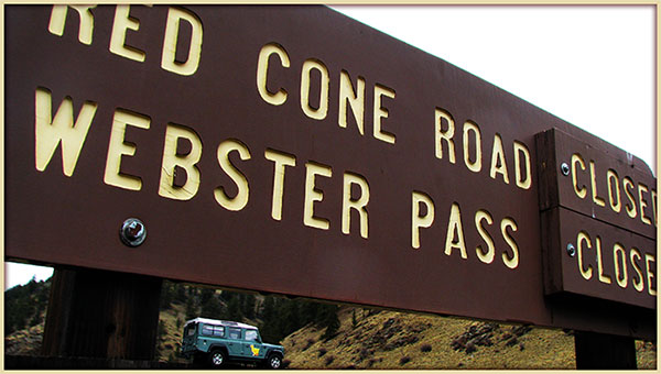
| Red Cone |
White River/Dillon
Pike/South Platte |
970-468-5400
303-275-5610 |
Open |
6/25/16 |
COMMENTS:
|
6/25/16 - Mile-Hi Jeep Club has cleared the trail and it is now open for the season.
5/24/16 - Trail is closed. Scheduled for opening by July 4th.
|
| Red Canyon Park |
Canyon City |
|
|
|
COMMENTS:
|
| |
| Richmond Hill |
Gunnison/Gunnison |
970-641-0471 |
Open |
6/24/16 |
COMMENTS:
|
|
6/24/16 - Richmond Hill Rd is passable from the top of Taylor Pass, to the Sundeck restaurant on the top of Aspen mountain.
|
| Rollins Pass - East Side |
Roosevelt/Boulder |
303-541-2500 |
Open |
7/16/16 |
COMMENTS:
|
7/16/16 - East side is open past Yankee Doodle lake. The snow drift is still there, but small enough that vehicles are getting thru.
6/26/16 - East side of Rollins Pass open to Yankee Doodle Lake. Long snow drift on west side of lake without adequate winching points makes Jeep passage difficult.
6/24/16 - Open to Yankee Doodle Lake. Road is completely blocked by 2-4' snow drift on shelf road just past parking area on west side of Lake.
Trail was dry most of the way, with some run off at upper elevations but nothing to note. There was a snow drift in last cut just before the lake, but pushed through with 35". There were several stock jeeps and pickup that also made it and were parked at the Lake.
6/17/16 - Made it just over 8 miles, to 10,500 ft. 2-3 foot snow drift - didn't attempt to pass.
6/5/16 - Rollins Pass road is open on the east side with some snow melt running down the trail in spots but dry for the most part.
There is a 2-3 foot deep patch of snow about 50-100 yards past the 2nd "Dip" sign headed up that had a Jeep running 35's or 37's
stuck and was about 3 or 4 car lengths long.
5/22/16 - Rollings Pass East trail is open to the first hairpin; snow just after that.
|
| Rollins Pass - West Side |
Arapaho/Sulphur |
970-887-4100 |
|
|
COMMENTS:
|
| |
| Red and White Mountain |
White River/Holy Cross |
970-827-5715 |
|
|
COMMENTS:
|
| |
| Saints John |
White River/Dillon |
970-468-5400 |
Partially Open |
6/25/16 |
COMMENTS:
|
6/25/16 - Trail is not yet open all the way. A quarter mile from it's intersection with North Fork Swan, there is a very large snowfield. All other drifts on the trail were dug out by Mile-Hi Jeep Club.
6/18/16 - Closed about 3/4 mile past the mine. Lots of water on trail. After passing the mine and the cabin we ran into snow on the trail about 3/4 up. Atleast 3 ft deep in shady areas.
|
| Santa Fe Peak |
White River/Dillon |
970-468-5400 |
Partially Open |
6/19/16 |
COMMENTS:
6/19/16 - Closed by snow at first switchback past mine, 3.0 miles from start of trail. Road is dry and remaining snow is melting fast.
|
| |
| Saran Wrap |
Pike National Forest |
Near Colorado Springs |
|
|
COMMENTS:
|
| |
| Schofield Pass |
White River/Sophris District |
970-963-2266 |
Open |
7/24/16 |
COMMENTS:
|
7/24/16 - Went up from Marble. This trail is not for beginners but certainly enjoyed it and encourage those that know how to crawl over rocks to protect their sumps to go for it. I never felt at all like I was going to die... Just thought I might scratch some paint or pop a tire. Rock slide just up a little ways past punch howls is gnarly. Bolder sits on the downhill side and you have to crawl around it on the uphill side.
What a great trail. Went up to the pass and came back down. Oh, pretty crazy trying to find pull over spots when meeting people. Did lead king basin on the way back and that is a GREAT trail if you like mountain streams and big valley views.
photo here and here.
7/14/16 - As of Thursday 7/14/16 the trail was passable and open all the way. I came from the Crested Butte side and had no issues with a stock 2011 Wrangler Sport. Yes, it was a little dicey coming down towards the bridge with some big rocks to negotiate around, but the road was stable with no washouts. Unless something happened between Thursday and Sunday but weather has been dry as far as I know.
7/17/16 - We attempted the pass from Crystal in a short wheelbase G500 with center and rear diff locked.
There was one very small but technical wheel sized wash out on the stream side of the road which got our attention as the vehicle began to slide. I reversed and used some momentum to power across it. There were several large rocks which are unavoidable but my rig has great clearance so we tip toed over them. We got to the bridge and met a group of ATV'ers who came down from Crested Butte. They unanimously told us NOT to continue as the road from the bridge to CB was washed out in places and they described an angle our vehicle would be on which they felt was dangerous so we reversed course. I had to deal with the wash again and used momentum. If this gets worse it will become an issue. Sorry I don't have a more precise location but on the CB side of it the road is wet, if this helps.
7/2/16 - Open all the way. We didn't travel this trail, but talked to another vehicle in Crystal who came from Crested Butte
via Schofield Pass, verifying it's open. And we came to Crystal from Marble, so it's open all the way.
6/24/16 - Yes. Open from Crested Butte to Schofield Pass. Likely open all the way to Crystal Mill.
We turned around at the first major stream crossing after Schofield Pass as it was not passable on a dirtbike.
6/18/16 - Blocked by snow just before the pass sign. Maybe another week.
|
| Scotch Creek |
Uncompahgre/Ouray |
970-240-5300 |
Partially Open |
5/18/16 |
COMMENTS:
|
|
5/18/16 - Open to the snow per the Forest Service. |
| Sevenmile |
San Isabel/Salida |
719-539-3591 |
|
|
COMMENTS:
|
| |
| Sheep Creek |
BLM Mesa County |
|
Open |
5/15/16 |
COMMENTS:
5/15/16 - A dozer has removed some rockfalls and washouts that were a problem. The trail is in very good condition until the next rain settles the loose sand and the rocks come up again.
5/15/16 - Sheep Creek is open. Sheep Creek is open. There has been a dozer working all the way to the cliff. That part of the trail is temporarily smooth. One or two rains will change that.
|
| |
| Sheridan Hill |
Clear Creek |
303-567-3000 |
Open |
6/18/16 |
COMMENTS:
6/18/16 - Traveled from Kingston Peak (353) and took 772.1 from the old mud pits over to Yankee Hill trail system. Trail clear all the way.
|
|
|
| Sheephorn Mountain |
White River |
970-468-5400 |
|
|
COMMENTS:
|
|
|
| Shrine Pass |
White River/Holy Cross
White River/Dillon |
970-827-5715
970-468-5400 |
|
|
COMMENTS:
|
| |
| Sidney Basin |
Uncompahgre/Ouray |
970-240-5300
970 |
|
|
COMMENTS:
|
| |
Slate River Road/Paradise Divide
FR317, FR 734 |
Gunnison |
970-641-0471 |
Partially Open |
6/27/16 |
COMMENTS:
|
6/27/16 - Yes. Open all the way from Crested Butte to Paradise Divide via Slate River Road. Road from Paradise divide to Schofield pass is not passable except by dirtbike. Snow is very hard and easily driven over but will likely be 3 weeks before its melted through for cars. about 8ft deep.
6/17/16 - Blocked by snow approx 0.8 miles after Washington gulch meets up with slate river road. 3-4 foot drifts.
|
| Slaughterhouse Gulch |
Pike/South Platte |
303-275-5610 |
|
|
COMMENTS:
|
| |
| Slide Lake |
White River/Holy Cross |
970-827-5715 |
|
|
COMMENTS:
|
| |
| Spring Creek |
Arapaho/Clear Creek |
303-567-3000 |
Open |
6/12/16 |
COMMENTS:
|
|
6/12/16 - The trail is clear from start to finish. The rock garden is pretty ruff this year.but passable in many ways! |
| Stony Pass |
Uncompahgre/Ouray |
970-240-5300 |
Open |
6/19/16 |
COMMENTS:
|
|
6/19/16 - Trail is open all the way. I went from east to west and met plenty of traffic coming up from Silverton.
Lots of water crossings on the east side and somewhat rough and rutted in a few places. A little snow left by the road on top. The Rio Grande was a bit high still, so vehicle with less clearance will find the crossings above Beartown interesting.
|
Summitville Trail
FR250, FR330, FR380 |
Rio Grande/Conejos
| 719-274-8971 |
|
|
COMMENTS:
|
| |
| Swan River Road - Middle Fork |
White River/Dillon |
970-468-5400 |
Partially Open |
6/25/16 |
COMMENTS:
|
6/25/16 - Trail has been cleared to the top where it intersects with Deer Creek. There are some sections with some slippery snow still, but that should be melted very soon.
6/11/16 - OPEN but will hit snow a few miles up.
5/28/16 - From Tiger Rd side large snow drifts before gate.
Large snow drifts well before the gate and river crossing. No tracks.
|
Swan River Road - North Fork & Wise Mountain
FR354 |
White River/Dillon |
970-468-5400 |
Open? |
6/25/16 |
COMMENTS:
6/25/16 - There is one remaining drift just before it intersects with Deer Creek. Trail is clear 100% of the way for a high clearance Jeep on 35s as we busted through it. 98% of the way for any stockers because that drift would be impossible for anything with low clearance. Please stay the trail and do not go around said drift! Many dirt bikes in the area driving around illegally.
6/11/16 - Gate open but deep patchy snow just before Garibaldi Gulch.
|
| |
| Swan River Road - South Fork |
White River/Dillon |
970-468-5400 |
|
|
COMMENTS:
|
| |
| Tabeguache Trail |
BLM |
Grand Junction |
Partially Open |
6/2/16 |
COMMENTS:
|
| 6/2/16 - The Tabeguache Trail begins in the Bangs Canyon area south of Grand Junction. It runs all the way to Montrose, but there are sections that are single track with bypasses for full-size vehicles.
The crossing at Hwy 141 near Whitewater currently has a locked gate until we can get the DOT to allow licensed vehicles access to the highway.
This is a strong class 6+ trail. Several rock gardens with large rocks protruding from the surface require high ground clearance or very good driving. From the Bangs Cyn. staging area, it's about 19 miles to the gate. This trip typically takes 4 to 5 hours one way, so plan for a long day if you plan to do the entire trail to hwy 141.
|
Taylor Mountain
CR228/FR330 |
Chaffee County |
719-539-6961 |
|
|
COMMENTS:
|
| |
| Taylor Pass |
Gunnison/Gunnison |
970-641-0471 |
Open |
7/4/16 |
COMMENTS:
|
7/4/16 - Rode from Taylor Park over Taylor Pass all the way to Aspen. Looked like the pass has probably been open a week or more. Taylor Pass is the same as always, rocky and fun.
6/24/16 - Taylor Pass is passable on the Express Creek side, but buried in deep snow at the top of the Taylor river side.
Cleared the last snow on June 24th. Photo here of the summit. The driver who choose this path said that "He didn't see any sign."
6/24/16 - On the Express Creek side, snow blocks the road approximately 1/2 mile past the small bridge. The summit is probably only a half mile further. Photo here.
6/14/16 - From the Castle Creek side on Express Creek Rd, the road is blocked by snow just above the small bridge that takes you to the other side of the valley.
Deep snow on a road surface of decomposed granite. The outer foot is not stable and will give way very easily. There is only a slim chance of recovery if you get off the edge.
Photo here. Be careful out there.
|
Tincup Pass
FR267 |
San Isabel/Salida
Gunnison/Gunnison |
719-539-3591
970-641-0471 |
Open |
7/20/16 |
COMMENTS:
|
7/20/16 - Made the Tincup loop. Mirror lake passing by water is great. Went over Hancock pass with no issues. Back around Cumberland Pass was good. No snow on any pass roads.
7/3/16 - We recovered a vehicle off the edge at the top. We were able to drive past the snowfield and get to the top. Did not drive the tincup side as it was late. Atv's have been running it for a few days now.
7/2/16 - Open all the way for 50". Sketchy with anything wider but probably good up to 60". Won't be long before full size vehicles can pass.
6/29/16 - trail partially blocked with snow near summit from St Elmo side. Enough room for a dirt bike maybe, nothing wider.
6/29/16 - Drove the trail westward from St Elmo. No problems until the very top. A section probably 100 yards long covered by snow. There was about 18" clear on the outer edge, but that tightened down to about 12" halfway thru. Basically just a walking path. I was on a bike, but still looked too dicey for me to try.
6/26/16 - Closed at last switchback. Dirtbikes can make it.
Bought a $4 shovel from a guy in St. Elmo and dug out the trail for 2 hours. Snowpack is still deep and about 200 ft wide.
The path we cleared is only wide enough for dirt bikes to get through and it is very sketchy. You will want another rider to assist.
6/24/16 - Trail not open all the way. Traveled from St Elmo, made it past the last switchback several hundred yards. Snow completedly blocking trail but don't
know how far. Trail is pretty rocky but no washouts.
6/20/16 - Not open to go over the pass from the east side. It is open from St Elmo up to the last switchback before the pass where it is snow packed.
Trail from St Elmo westward is very rocky but is not blocked up to the last switchback before the pass. No wash outs or blockage until that point.
6/4/16 - We traveled from the town of Tin Cup on the west side up to Mirror Lake. The trail is not flooded around the lake like last year and you can only travel a few hundred feet above Mirror Lake and the snow drifts are too deep to travel further.
|
| Tomichi Pass |
Gunnison/Gunnison |
970-641-0471 |
Open; |
7/16/16 |
COMMENTS:
|
7/16/16 - The trail is completely open and passable. Went over it in an open diff, mildly lifted 3rd gen 4runner without incident. All the water crossings were less than 15" deep and presented no problems.
Trail is rough with almost no smooth runs, but is is sound condition and the thin Ridgeline run (with the rusted out, rolled Land
Cruiser at the bottom of the slope) looks to have recently been built up on the drop side.
7/10/16 - Tomichi Pass is open from White Pine to Hayden Pass. Same as always, rocky.
|
Transfer Trail
FR602 |
White River |
970-468-5400 |
Partially Open |
6/19/16 |
COMMENTS:
|
|
6/19/16 - Coming out of Glenwood Springs you can mke it about 8 miles or so.
Large trees blocking road. Also some snow drifts but not sure how deep. If you had a chainsaw you could put in some work and get through
|
| Treasure Mountain Loop |
Uncompahgre/Ouray |
970-240-5300 |
|
|
COMMENTS:
|
| |
| Turner Gulch |
Pike/Fairplay |
719-836-2031 |
|
|
COMMENTS:
|
| |
| Twin Cone |
Pike, South Platte |
719-836-2031 |
Open |
7/11/16 |
COMMENTS:
|
| 7/11/16 - Open to the top, dry and in great condition. Super fun trail. |
| Uncompahgre Plateau Area |
Grand Valley |
970-242-8211 |
|
|
COMMENTS:
|
| |
| Wager Gulch |
Uncompahgre/Ouray
BLM/Gunnison |
970-240-5300
970-641-0471 |
|
|
COMMENTS:
|
| |
| Warden Gulch |
White River/Dillon |
970-468-5400 |
Open |
6/20/16 |
COMMENTS:
6/20/16 - Yes, drove thru snowbank a you can now make it all the way to top. Snowbank a near top but passable
|
| |
| Wearyman Creek (FS747) |
White River/Holy Cross |
970-827-5715 |
Open |
6/21/16 |
COMMENTS:
|
| 6/21/16 - No issues. Water running down lower trail. Hub depth at most. Snow banks almost gone. Dry everywhere else.
|
| Webster Pass/Handcart Gulch |
White River/Dillon
Pike/South Platte |
970-468-5400
303-275-5610 |
Open |
8/1/16 |
COMMENTS:
|
8/1/16 - The trail is open all the way. The sign shows Webster CLOSED and Red Cone OPEN. But we decided to take our chances and try Webster. There is a minor snow bank at the very top which is easily passable. Enjoy!
7/31/16 - Open all the way. Looks like someone shoveled the last remaining snow on the Handcart Gulch side just below the top just enough for vehicles to get by. Also, the narrow, tippy spot on one of the lower segments (toward Handcart Gulch) seems to have been filled in on the downhill side to make it more passable. Thanks to whomever performed this trail maintenance!
7/25/16 - Trail on the south side of Webster Pass is still blocked by a large snow pack.
Snow pack blocking trail is about 40 feet from the pass and covers all but about 1.5 feet of the trail. It will take some time for the amount of snow to melt.
7/24/16 - Still drifted shut. 4 wheelers and side by sides can make it but not wide enough for my small Jeep.
7/9/16 - Traveled from the north (Montezuma) side to the summit. The road was in good shape.
There is still a snow drift left over from the cornice blocking the south side just below the summit.
It will probably still be two to three weeks before it opens unless a crew shovels it out. Here is a link to a couple pictures
of the drift.
6/25/16 - Not open. South side is free of snow until the last 100 yards or so.
Lots of water! A big cornice at the top is the only thing blocking the trail. Probably 2-3 more weeks until its clear.
6/25/16 - Trail is clear from top to bottom on the Montezuma side.
Few lingering snow drifts that would be a challenge for a small stock SUV, but should be melted within a week.
6/20/16 - 2/3 way up Handcart Gulch the snow blocks trail as it's about 3-4 feet deep with about 10+ up higher
Trail has lots of runoff running down it but water crossings are doable as generally less than 30 inches.
6/18/16 - Closed past big creek crossing on Montezuma side. 150 yards past the big creek crossing on the Montezuma side
the snow covering the trail was close to 4ft tall. Lots of melting but it will still take awhile. Photo of water running down the trail
6/11/16 - From the 285 side, Mile-Hi Jeep Club has cleared the trail to the start of the shelf road switchbacks, 4 miles in.
6/5/16 - : The trail is not open all the way on the 285 side. We made it about 3/4's of the way up where you get in the Valley below Red Cone, before the tillings pile, and there was 3-4 foot drifts across the road for quite a ways. Very slushy and muddy so we turned around.
Lots of downed trees along the trail and a few across the trail. Still alot of snow and fairly muddy the hire you get
|
Weston Pass
CR7 |
Pike/Fairplay
San Isabel/Leadville |
719-836-2031
719-486-0749 |
Open |
6/16/16 |
COMMENTS:
|
6/16/16 - We traveled from Leadville on CR7 over the Pass and down on CR22. Road is clear of snow. There are a few potholes, some water-bar damage and a little wash-board.
6/4/16 - From the west on CR7 the trail is not navigable at aprx 11,500 ft. due to snow drifts. This is a little over a mile from the top of the pass.
6/6/16 - Called number provided, and told one side is open all most all the way to the top, but the other side is still snow covered. She couldn't tell me anything more than that.
|
| Wheeler Geological Area |
Rio Grande/Conejos
| 719-274-8971 |
Open |
6/22/16 |
COMMENTS:
|
|
6/22/16 - Forest Service has opened the road. It's wet and a bit muddy, but open to the top. |
| Wheeler Lake |
Pike/South Park |
719-836-2031 |
Open |
7/15/16 |
COMMENTS:
|
7/15/16 - Open all the way. Fun as always.
6/18/16 - Trail not open all the way, blocked by several snow drifts. First drift we encountered 2.5 miles from wheeler lake over 8 feet deep. Hiked further up and found more snow drifts.
Trail condition good, lots of water and mud around bases of major obstacles caused some grip issues. Can be accomplished with factory Jeep Rubicon, and some driving skill.
|
| Williams Pass |
San Isabel/Salida |
719-539-3591 |
|
|
COMMENTS:
|
| |
| Wurts Ditch Road |
White River/Holy Cross |
970-827-5715 |
|
|
COMMENTS:
|
| |
| Yankee Boy Basin |
Uncompahgre/Ouray
BLM/Gunnison |
970-240-5300
970-641-0471 |
Partially Open |
7/15/16 |
COMMENTS:
|
7/15 - Open all the way EXCEPT the last 1/4 mile. Blocked 1/4 mile from the top by a snow bank.
6/1/16 - Closed at snow in upper basin.
5/8/16 - The gate is open, and the road has been plowed. We don't know how far up, but I'm assuming at least to the turn
off for Yankee Boy. We stopped at the Notch, as we were out of time, but the road was in great shape to that point.
In fact, a guy in a white chevy van drove by us on his way up. |
| Yankee Hill |
Arapaho/Clear Creek |
303-567-3000 |
Open |
7/13/16 |
COMMENTS:
|
7/13/16 - All the trials I rode from the Colorado Backroads Book are open. I can't imagine any not being dry and open.
6/9/16 - Travelled all the way from St Mary's to Central City. Open all the way. Saw a couple of bull moose just above St Mary's.
5/23/16 - Not open all the way yet. Running from Central City towards St. Marys you can make it about 5 miles until the snow is too deep to pass.
There was a multi-vehicle extraction of a full size Chevy going on at the time we came to this spot.
Trail is in otherwise good condition, a bit rougher than it has been in previous years. There is A LOT of trash along the trail for some reason- please bring a large trash bag and help pitch in by picking up some of this trash please.
|
|
|
|
|
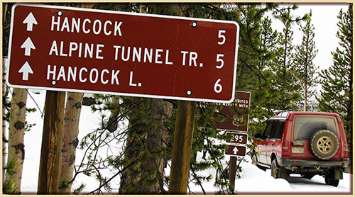 This is
the page for the 2016 Colorado Pass page. You can add to this page and
This is
the page for the 2016 Colorado Pass page. You can add to this page and


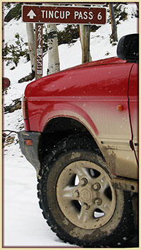 As a guide, you can view the dates and information from the