|
CANYON DE CHELLY JEEP TRAIL, NAVAJO NATION, ARIZONAJuly 1998
 Arizona, U.S.A. Not just a cacti-filled desert, but a state of varied and beautiful scenery. Certainly there is the Sonoran Desert, where the giant saguaro cactus, star of many western movies is found, but there is also a diverse range of high mountains, pine forests, verdant riparian communities, and arid chaparral covered plains. We were living in Phoenix the capital when this article was written, working hard in the week and escaping its sweatbox tendencies by going bush at weekends.
We loaded up Juan, our Jeep Cherokee (so named, because as the ads say, "There is only Juan Jeep") and a four hour drive on the Friday night took us past the picturesque town of Flagstaff, elevation 7,500 feet, where a stop for petrol had us feeling somewhat chilly in our shorts and T-shirts. We were expecting to have difficulties finding somewhere to camp for the night. Arizona was at the start of the driest summer for twenty or so years, and the whole state was a tinderbox, with several wildfires being reported. One or two were blazing out of control and engulfing large areas of National Park and forest. The solution was drastic and to the point. A total fire ban was enforced and all public access to high risk areas was barred. This included hundreds of square miles of National Forest (whose normal access rules resemble Australian State Forests) and the ban extended to walkers, campers, horse-riders, and vehicles. The Coconino Forest surrounding Flagstaff was mainly closed, but we found an open quiet track on the edge of the forest and made camp on the edge of a volcanic area, where the cinders crunched underfoot and the stars circled overhead.
The next day saw us entering the Navajo Nation from the south, heading up to Canyon De Chelly (pronounced d'shay). The name comes from a corruption of the Navajo word for rock, "Tseyi". The main feature is a spectacular red rock canyon of deep gorges, pictographs and petroglyphs, and stark, high canyon walls. The immediate area of the canyon is a National Monument, and access is strictly controlled by the Navajo, for whom the canyon represents a sacred place, as well as a livelihood for some. Anyone is permitted to hike and drive around the rim of De Chelly and its equally spectacular offshoot Canyon Del Muerto, but if you wish to hike, camp, or drive within the canyon itself it is necessary to obtain the services of an authorized Navajo Guide. Guides will accompany you either on foot, horseback or in your own 4WD. This can be done on an individual basis or by taking a commercial tour. We had decided on the former, and arrived at the Visitor Center at 10a.m.. Expecting to wait until a guide was available, we were in and out within ten minutes, now in the company of Michelle, our guide. She directed us down the road to the turn off for the canyon, past the battery of signs prohibiting unauthorized entry and into the sandy wash of the riverbed. Immediately the sand was loose and deep and Juan struggled in the deep ruts. A quick stop to let the tyres down and he was fine.
One thing that differentiates Canyon De Chelly from the numerous other canyons in the southwest, is the fact that it is still used by the Navajo for farming. Each traditional farm is small, only about a quarter of an acre, but each is fenced, either for grazing or planting with corn. Most have a small hogan, the traditional round dwelling, or else a shade shelter and cooking area for camping out. The Navajo traditionally live in the canyon in the summer months. Michelle explained that land was passed down to the daughters of the family and farms had to be actively worked in order to retain the land. If a farm goes unworked for two years then anyone else with a traditional claim to the area can step in and start working. Michelle was currently working three farms: her own, her grandparents', and her brother's. Livestock freely roamed the canyon, mainly flocks of sheep, some cattle and many horses.
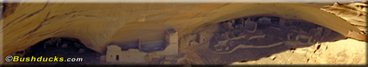
"First Ruin", said Michelle. "Also known as Last Ruin." About one hundred feet up under an overhang was a small adobe and wood cliff dwelling typical of the southwest. First Ruin was small, only a dozen or so rooms and one kiva (ceremonial room), there was plenty of others - whole pueblos and communities where dozens of families lived. Access up the sheer cliff was by ladder, providing wonderful defense. The ruins in Canyon De Chelly date back to about 1200AD, and like the majority of cliff dwellings were abruptly abandoned after only one or two generations. The reason is unclear: disease, famine, flood, drought, conflict with neighboring tribes, or religious reasons have all been suggested. Maybe they just got itchy feet and wanted to try living somewhere else. It happens to the best of us! Once in Canyon Del Muerto the going was easier. We stopped to marvel at the myriad of dwellings scattered around and about; Standing Cow Ruin, Corn Cob Ruin, Kokopelli Ruin - each was different and all in their original state. No repairs are carried out by the Parks Service, unlike at some of the more accessible ruins. A furry coyote ran across the track in front of us, and paused dingo-like to regard us warily before slinking off. "There are bears here too occasionally," said Michelle. "They come down from the canyon rim to eat the prickly pear fruit. Big black ones. If you are camping make sure you have a pepper spray for defense, they are bad this year because of the drought." A Chevy ute roared past us, slewing around in the soft sand. Michelle waved and roared something in the slightly slurry Navajo tongue. "Friends?" we asked. "My uncle's cousins," she replied. "I told them to slow down." We proceeded on slowly, stopping often for photographs, to ponder the rock art, or simply admire the view. After the main canyon junction the sand was less deep and eventually the track left the wash and wound around, criss-crossing the creek bed. We pulled over to the side to let one of the commercial tour operators past. The twenty-four seater open-topped army vehicle thundered past us with many a wave from the sunburned passengers, who looked enviously at our leisurely progress. "We call them the 'Shake 'n Bakes'," said Michelle. "They have three hours to get up the canyon and back again. Lots of shake, rattle, and roll." Antelope House is the most substantial ruin in Canyon Del Muerto. When viewed from the lookout 1,000 feet up on the canyon rim, you can appreciate the full extent of the dwellings. From ground level we could see the accuracy of the ancient mud bricks and see how well the dwellings blended in with the cliff.
"My husband's brother. He has the farm we passed with the corn and sheep." We continued on, splashing through the shallow creek. Michelle told us how vehicles are regularly lost when the summer storms come raging down the canyon, turning the creek into a mass of mud and water. She broke off in her narrative to wave at a man mending a fence. "My second cousin; he farms this by himself. His teenage sons won't help him, they don't want to live the Navajo way. They want a fancy house with lots of possessions." The accessible track up the canyon ended at the 21 mile mark at Mummys Cave. This cliff dwelling, set high up in the cliff face was named after the mummified remains of two men found in a ceremonial chamber. We shared some lunch perched on the roots of a large elm tree before retracing our steps down the bumpy track. The journey back was silent; we had asked our questions, and been given a warm insight into the lives of the canyon residents, both past and present. Six hours had elapsed since we left the visitor center. We had enjoyed a stimulating drive, some beautiful scenery, and friendly company. Most of all, for a short while we had been permitted to share Michelle's way of life and gain an insight into the Navajo way. Canyon De Chelly is a special place and in this case, adhering to the access restrictions enhanced our appreciation and enjoyment. And best of all, it was only 4 p.m. and we had a remote and beautiful bush camp to look forward to, and a Sunday of exploring more of this wonderful corner of Arizona. And where was our pepper spray? Back in Phoenix of course. But that is another story.
© Bushducks, 1998
Now available as regional guides for your glovebox:

Be informed when this site is updated: |
 With temperatures consistently reaching highs well into the 40's, we felt a weekend in the
cooler, high altitudes was called for. The Navajo Nation beckoned. The largest Indian
Reservation in the country, spreading over the corners of four states - Utah, New Mexico,
Colorado, and Arizona, it has its own laws and government, co-existing with the United States government. Visitors are welcome, but are bound by tribal law, which includes
limitations on access to sacred areas and a total ban on the use or possession of alcohol.
With temperatures consistently reaching highs well into the 40's, we felt a weekend in the
cooler, high altitudes was called for. The Navajo Nation beckoned. The largest Indian
Reservation in the country, spreading over the corners of four states - Utah, New Mexico,
Colorado, and Arizona, it has its own laws and government, co-existing with the United States government. Visitors are welcome, but are bound by tribal law, which includes
limitations on access to sacred areas and a total ban on the use or possession of alcohol. 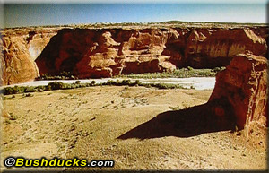 The canyon walls were about three hundred feet high at the mouth; a fortress of red rock surrounding the wide,
sandy wash with Cottonwood trees growing along the walls. Michelle bade us stop at the first
rock art site and pointed out the carvings and paintings. Some very familiar images were the handprints,
identical to the handprints found in Australian Aboriginal rock paintings. Both the solid and the outline
sorts were represented, but Michelle had no explanation as to their significance, other than as
a "We were here" mark.
The canyon walls were about three hundred feet high at the mouth; a fortress of red rock surrounding the wide,
sandy wash with Cottonwood trees growing along the walls. Michelle bade us stop at the first
rock art site and pointed out the carvings and paintings. Some very familiar images were the handprints,
identical to the handprints found in Australian Aboriginal rock paintings. Both the solid and the outline
sorts were represented, but Michelle had no explanation as to their significance, other than as
a "We were here" mark.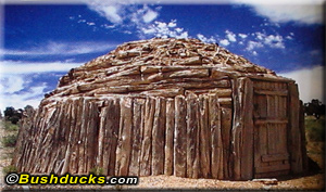 The sand became deeper and looser and the sheer rock walls higher as we approached the junction
of Canyon Del Muerto, "Canyon of the Dead". Juan was heating up slightly in the thirty degree celsius heat
and we were pleased to stop at the first of the many cliff dwellings in the canyon.
The sand became deeper and looser and the sheer rock walls higher as we approached the junction
of Canyon Del Muerto, "Canyon of the Dead". Juan was heating up slightly in the thirty degree celsius heat
and we were pleased to stop at the first of the many cliff dwellings in the canyon.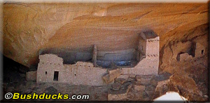 The scenery was changing. Gone was the wide wash with deep sand to both walls. The canyon was
narrower with many offshoots. Twin Trails Canyon; Black Canyon. The walls were higher, rising
to 1,000 feet and the rock formations were more twisted and striking. Michelle pointed out the shape of
a dog, a man with a stick, and an ancient fortress perched high upon an isolated outcrop. Three
horses cantered past us, the last rider waving. Michelle waved back.
The scenery was changing. Gone was the wide wash with deep sand to both walls. The canyon was
narrower with many offshoots. Twin Trails Canyon; Black Canyon. The walls were higher, rising
to 1,000 feet and the rock formations were more twisted and striking. Michelle pointed out the shape of
a dog, a man with a stick, and an ancient fortress perched high upon an isolated outcrop. Three
horses cantered past us, the last rider waving. Michelle waved back. Back Country Adventures: Arizona
 Arizona Trails Central Region
 Arizona Trails West Region
 Arizona Trails Northeast Region
 Arizona Trails South Region