|
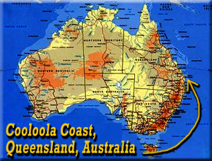 THE COOLOOLA COAST, QUEENSLAND, AUSTRALIAby Bushducks
The Cooloola coast is a beautiful region of coastal rainforest and long sandy beaches, that invite the
traveler to cast themselves adrift and explore. Only two hours north of Brisbane, the area offers
a wealth of diverse and fantastic scenery to explore, with the added bonus of the many and varied
restaurants and hotels of Noosa.
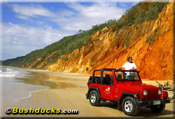
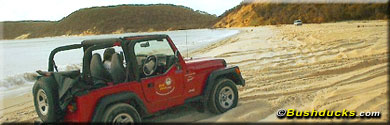
For the explorer who wants to see more than the Noosa National Park and the Hastings Street restaurants,
an excellent option is to hire a 4wd vehicle from one of the handful of companies that rent them. We
went to Henry's, a local company offering 4wd hire from Noosa, Tewantin and Maroochydore. They offer
the choice of small, sturdy Jeep Wranglers or the larger Toyota Prado, which is a more suitable option
for four people or a family. The Wranglers, with automatic transmission and soft tops that fold back
are perfect for two people. The sporty little engines are fun to drive and there is unparalleled scenery
viewing from the open top.
 The staff at Henry's can direct you as to the best places to go whether you have a day or a week to
explore the region. For those with only a day to spare, it is hard to go past the option of driving
up the long gently sloping expanse of Cooloola beach through the Cooloola section of the Great Sandy
National Park to Double Island Point. The return drive through a mixture of forest types adds contrast
to the day and makes full use of the Wrangler's four wheel drive. It is essential to check the tide
times before you leave as the beach is not accessible around high tide. The tourist office can provide
you with a chart of tide times for the various beaches, local radio stations broadcast the information
or ask the Henry's staff.
The staff at Henry's can direct you as to the best places to go whether you have a day or a week to
explore the region. For those with only a day to spare, it is hard to go past the option of driving
up the long gently sloping expanse of Cooloola beach through the Cooloola section of the Great Sandy
National Park to Double Island Point. The return drive through a mixture of forest types adds contrast
to the day and makes full use of the Wrangler's four wheel drive. It is essential to check the tide
times before you leave as the beach is not accessible around high tide. The tourist office can provide
you with a chart of tide times for the various beaches, local radio stations broadcast the information
or ask the Henry's staff.
The Tewantin office is the closest to the Tewantin River ferry, which takes you over to the seaboard
beaches. Within minutes we had the paperwork completed and were off for the day in the latest TJ Jeep
Wrangler, supplied to us by Henry's.
The Tewantin ferry shuttles back and forth across the mangrove and tea-tree lined river during its
operating hours, so normally the wait is only a few minutes. Once off the ferry, it is a short drive
to the beach. The road passes the Tidewater Hotel, a pleasant place for refreshment, particularly if
due to the tide times you have been driving the trip in the opposite direction and have time to stop
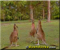
for a meal. Kangaroos can often be seen feeding in the grassy park next to the hotel. They are
unafraid of humans, but like all wild animals should be treated with respect. Keep your distance,
and of course, never feed any wild animals.
 The drive up the long, gently sloping beach to Double Island Point is an experience never to be forgotten.
There are few places in the world where this expanse of beach driving is permitted. The drive is a
popular one and as well as sight-seers, it is used by surf fisherman for access. Tailor are often
caught off the beach. Other fish that can be caught include whiting, bream, flathead, jew and dart.
Causaurinas or "She-oaks" and tea-tree line the edge of the beach, growing on the dunes. You are
likely to see sea falcons, large snowy-white birds with brown wings that frequent the beach and dunes.
And keep an eye out for sea-snakes, that often wash in with the surf. Other sealife you might be lucky
enough to get a glimpse of are dolphins, turtles and stingrays which can often be seen in the clear
waters around Double Island Point. In season, migrating whales pass this way too. Sealife of a more
gastronomic level are pipis, which you can dig for in the firm sand at low tide. The drive up the long, gently sloping beach to Double Island Point is an experience never to be forgotten.
There are few places in the world where this expanse of beach driving is permitted. The drive is a
popular one and as well as sight-seers, it is used by surf fisherman for access. Tailor are often
caught off the beach. Other fish that can be caught include whiting, bream, flathead, jew and dart.
Causaurinas or "She-oaks" and tea-tree line the edge of the beach, growing on the dunes. You are
likely to see sea falcons, large snowy-white birds with brown wings that frequent the beach and dunes.
And keep an eye out for sea-snakes, that often wash in with the surf. Other sealife you might be lucky
enough to get a glimpse of are dolphins, turtles and stingrays which can often be seen in the clear
waters around Double Island Point. In season, migrating whales pass this way too. Sealife of a more
gastronomic level are pipis, which you can dig for in the firm sand at low tide.
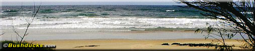
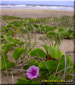
The clear blue waters of the South Pacific Ocean and the pounding surf make for a vivid contrast with
the drooping green vegetation on the foreshore and the white sands. You can swim most anywhere along
the beach, although the surf can be fierce and the beach is not patrolled. For strong swimmers though,
the waves are perfect for body surfing.
The sand of the beach is firm at low tide, but there are often gullies, drop offs and patches of loose
banked sand that make fast driving unadvisable. The rules of the road apply on the beach, keep to the
left and within the speed limit of 80 kph. Be courteous when passing other beach users and fishermen,
and avoid driving in the seawater - apart from the increased danger of getting stuck, evidence of salt
water spray over the vehicle will result in the loss of your security deposit.
One of the side tracks through the tea-tree covered dunes goes to the collection of beach houses and
holiday homes known as Teewah Village. When the Great Sandy National Park was being created, there was
still sand mining activity around Freshwater Lake. The National Parks and Wildlife Service created Teewah,
allocating one hundred blocks of land for residential houses at the current location. A land swap took
place, exchanging blocks of land at Teewah for the land at Freshwater that was slated for inclusion
within the new National Park. In 1980, a block of land at Teewah sold for $1000; nowadays it is far
more than that. No commercial activities are permitted in the village and although there is now a
telephone service to the village there is still no town water or electricity.
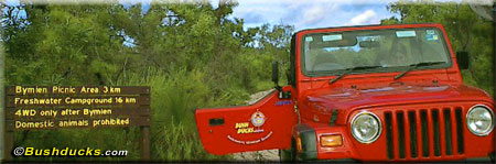
 The route enters into the Cooloola Section of the Great Sandy National Park, which is the largest
area of natural land on Queensland's south coast and covers over 56,000 hectares. There are many
walks within the park, ranging from short hikes to longer overnight hikes. No beach camping is
permitted in this section, although further to the north it is permitted with a permit, obtainable
on the spot from one of the self-pay stations. The informal sites have no facilities, but are tucked
into the tea-tree and dunes at the back of the beach. Domestic animals are not permitted and the
maximum stay is twenty-two days. A fee is charged. You are likely to see wild dingoes on the beach
here; as on Fraser Island, the wild dogs are often to be seen on the beach. Do not feed them; recent
attacks on humans, and the fatal attack on a nine-year old boy has increased public awareness of the
dangers of feeding wildlife, which is a federal offence. In the aftermath of the recent attacks,
transgressors are subject to the full force of the law. The route enters into the Cooloola Section of the Great Sandy National Park, which is the largest
area of natural land on Queensland's south coast and covers over 56,000 hectares. There are many
walks within the park, ranging from short hikes to longer overnight hikes. No beach camping is
permitted in this section, although further to the north it is permitted with a permit, obtainable
on the spot from one of the self-pay stations. The informal sites have no facilities, but are tucked
into the tea-tree and dunes at the back of the beach. Domestic animals are not permitted and the
maximum stay is twenty-two days. A fee is charged. You are likely to see wild dingoes on the beach
here; as on Fraser Island, the wild dogs are often to be seen on the beach. Do not feed them; recent
attacks on humans, and the fatal attack on a nine-year old boy has increased public awareness of the
dangers of feeding wildlife, which is a federal offence. In the aftermath of the recent attacks,
transgressors are subject to the full force of the law.
The next stop along the beach is Red Canyon. The narrow twisting canyon in the cliffs has been
sculpted by wind and rain over many years. The deep red cliffs are stained by iron oxide. A short
hike up Red Canyon is rewarding, especially for the photographer.
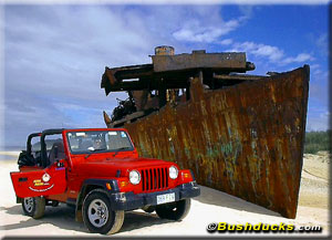
 Many people associate the Cooloola Coast with the wreck of the Cherry Venture, an eighteen hundred
ton cargo vessel which was driven ashore during a cyclone in 1973. Only the hull remains these days;
buried nearly upright in the sand, but it is a popular stop with tourists. Many people associate the Cooloola Coast with the wreck of the Cherry Venture, an eighteen hundred
ton cargo vessel which was driven ashore during a cyclone in 1973. Only the hull remains these days;
buried nearly upright in the sand, but it is a popular stop with tourists.
Access to Rainbow beach, on the north side of Double Island Point is a short distance past the
Cherry Venture. The boarded Leisha Track provides traction across the soft dunes. Once on Rainbow
Beach, the famous colored sands start less than three kilometers from the end of Leisha Track.
Like Red Canyon, the sands, in a wide range of reds, orange, terracotta, ochre and earth colors. Aboriginal
legend tells of an aboriginal spirit ancestor who threw himself into the sandcliffs during a fight for the woman he loved.
His blood stained the sands forever.
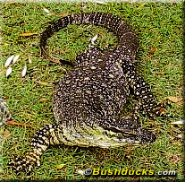 The main route leaves the beach up the Freshwater Track. Set back a short distance from the beach is
the open, grassy Freshwater Picnic Area. Picnic tables are set under shade trees. Here, you are almost
certain to see enormous goannas scavenging in the area and stalking like ponderous dragons through the
grass. They are harmless, but if startled they have been known to run in the opposite direction at great
speed and climb up a tree to escape. Don't stand in their way; people and trees look pretty much the
same if you are a goanna and their large claws can inadvertently do considerable damage. The goannas,
or lace monitors, eat nesting birds, flesh and other reptiles although the well-fed goannas at the
picnic area seem to do better scavenging in the rubbish. The main route leaves the beach up the Freshwater Track. Set back a short distance from the beach is
the open, grassy Freshwater Picnic Area. Picnic tables are set under shade trees. Here, you are almost
certain to see enormous goannas scavenging in the area and stalking like ponderous dragons through the
grass. They are harmless, but if startled they have been known to run in the opposite direction at great
speed and climb up a tree to escape. Don't stand in their way; people and trees look pretty much the
same if you are a goanna and their large claws can inadvertently do considerable damage. The goannas,
or lace monitors, eat nesting birds, flesh and other reptiles although the well-fed goannas at the
picnic area seem to do better scavenging in the rubbish.
Freshwater Lake is close to the picnic area. The small lake can be reached by a short hike from the
parking area and is a small pretty reed fringed lake set just over a kilometer from the beach. For
those not wanting to brave the surf and rip tides, Freshwater Lake can be a cooling place for a dip.
The lake is set in the low sandstone hills amidst paperbarks and is frequented by waterfowl. It is
part of the catchment area for the Noosa River, which spills out through Noosa Heads to the South
Pacific Ocean.
The traditional ownership of the Cooloola Region was the Gubbi-Gubbi or Daringbara aboriginal tribes.
It is they that named Noosa after the aboriginal word for a shade tree or shadows. The Cooloola region
has seen its fair share of industry over the years. Sand mining started in Rainbow Beach and on Fraser
Island between the 1950's to 1970's. Timber was a large industry in the mid 1800's and continued up to
1991. The steam engine, 'The Mary Ann', operated on the railway system to harvest the northern forests.
The logs were taken by railway to Poverty Point, where they were floated to the timber mills at
Maryborough. Later the logs were moved to the west and winched across the Noosa River. By the 1900's,
dairy cattle, grazing and sugarcane had replaced logging as the main industry.
 The remainder of the drive takes you along a twisting sandy track, passing first through open forest,
with tall trees and a fairly open forest of banksia, gum trees and the occasional grasstree. Watch
for scribbly gum - the bark of these trees is patterned with the whorls and meanderings of a burrowing
insect that leaves its characteristic patterns on the bark. Watch out for oncoming traffic in this
section, the narrow track is only wide enough for a single vehicle and vehicles often travel fast to
pass through the patches of soft sand. The trail is more difficult in the reverse direction where
some sandy ascents may cause a few problems for the unwary. The open forest gives way to a section
of rainforest; here vines, figs, lilly-pillys, myrtles and palm trees mingle in glorious deep green
profusion. The air is alive with the bird calls. The remainder of the drive takes you along a twisting sandy track, passing first through open forest,
with tall trees and a fairly open forest of banksia, gum trees and the occasional grasstree. Watch
for scribbly gum - the bark of these trees is patterned with the whorls and meanderings of a burrowing
insect that leaves its characteristic patterns on the bark. Watch out for oncoming traffic in this
section, the narrow track is only wide enough for a single vehicle and vehicles often travel fast to
pass through the patches of soft sand. The trail is more difficult in the reverse direction where
some sandy ascents may cause a few problems for the unwary. The open forest gives way to a section
of rainforest; here vines, figs, lilly-pillys, myrtles and palm trees mingle in glorious deep green
profusion. The air is alive with the bird calls.
The trail passes the Bymien Picnic Area before ending at the T intersection with the Rainbow Beach Road.
The small town of Rainbow Beach, the jump off point for the well-known Fraser Islan, is a short distance to the right; turn left to return to Tewantin via
a choice of paved or forest roads.
We returned to Tewantin through Kin Kin and the smaller paved roads that run through rolling
farmland. The Henry's Jeep proved itself to be a fun and reliable car for the trip, the perfect
vehicle for such a day out.
Route Directions:
From Tewantin, turn to the north up Moorindil Street, following the road signs to the
Noosa River Ferry. Zero the trip meter at the ferry.
| Kilometers | Directions |
| 0.0 | Continue on the paved road towards the beach, following the signs for beach access. Pass the Tidewater Hotel on your left. |
| 4.7 | First Cutting. Enter onto the beach and turn left, to the north. |
| 5.9 | Second Cutting on the left returns to the ferry. |
| 7.9 | Third Cutting on left returns to the ferry. |
| 13.7 | Entrance to Teewah Village on left. Residential houses. Zero trip meter at the entrance and continue along the beach. |
| 0.0 | |
| 0.5 | Enter the Great Sandy National Park, Cooloola Section. No camping permitted in this section. |
| 1.0 | Hang gliding platform on left at top of cliff. |
| 14.2 | Start of camping area, camping permitted for the next 15km, camping permits obtained on the left at the information board. Domestic animals prohibited. |
| 19.6 | Red Canyon on left. |
| 20.5 | Kings Bore Road on left is no entry from this end. |
| 29.1 | Little Freshwater Creek. No beach camping past this point. Camping permits available here on the left at the information board. |
| 32.1 | Freshwater Road on left. Turn left here following the sign to Freshwater Camping Area, Freshwater Lake and Rainbow Beach. Zero trip meter. If you continue straight ahead along the beach at this point you will reach the Cherry Venture shipwreck in 5.3 kms. Leisha Track, a further 0.6 km goes to Rainbow Beach, although there is normally no access to the township from the beach.
GPS coordinates for the Cherry Venture are: S25º58.00' W153º10.00' |
| 0.0 | |
| 0.5 | Freshwater Picnic Area. |
| 1.5 | Freshwater Lake and campground. |
| 10.3 | Burwilla Lookout trail on right, closed due to erosion of sandcliffs. |
| 14.4 | Hiking trail on left to Bymien Picnic Area, Poona Lake and Freshwater Lake. On the right is the hiking trail to Rainbow Beach. |
| 15.0 | Bymien Picnic Area on left, carpark and picnic area
 |
| 18.2 | T intersection with paved Rainbow Beach Road. Turn right for Rainbow Beach, turn left to return to Tewantin, either via the paved roads through Kin Kin or via the sandy Cooloola Way. Total driving distance for the day is approximately 150km, depending on the return route chosen. |
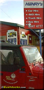 Henry's Transport Group
Tel (international):61-7- 5447-4777 (Noosa) or 61-7-5479-0992 (Maroochydore)
A Jeep Wrangler costs A$135 per day for beach driving.
Tewantin River Ferry: Standard vehicle A$4.00
Hours: November to January, Sunday to Thursday 04:30 - 22:30
Friday and Saturday, 04:30 - 00:30
February to October, Friday 06:00 - 00:30, Saturday 05:00 - 00:30, Sunday 05:00 - 22:30
Monday to Thursday, 06:00 - 22:30
Maps: The old but detailed black and white map "Cooloola Coast National Parks" is available
locally and shows all the tracks mentioned in this article.
© Bushducks 2001
All photos © Bushducks 2001

Home
Back Country Itineraries
Adventure Publications
High Country Pass Status
Adventure Travel Tales
Bushducks Land Rover
Links
Be informed when this site is updated:
 |
|