|
El Camino del DiabloMarch 2000
One trail, however, offers a remote experience, beautiful scenery and vegetation, history, and due to its position, along the international border with Mexico, a unique perspective of life along the border. El Camino Del Diablo, Spanish for 'the devil's highway', is a one hundred plus miles of sandy, single track trail that winds through the Sonoran desert zone of Arizona. Along its length, it travels through a National Wildlife Refuge, a National Park, within a mile of the international border with Mexico, and through the middle of a military live bombing range. Traveling by ourselves in our auto V8 Discovery, 'Drover', we started the trail at Yuma, situated on the Colorado River on the California border. Only a hundred years ago, Yuma was a military fort, protecting the settlers from Indian attacks and keeping open the trade routes to the Pacific coast. Nowadays, it is a bustling town, supporting the local military bases and during the winter months, a booming population of 'snowbirds', retired refugees from America's northern wintry climes.
The two of us, and Drover, left Yuma on a brilliantly sunny day. The first section of the road is an easy, graded trail, as it runs alongside the western flank of the Tinajas Altas Range, heading in a plumb line for Mexico, along the edge of the military bombing range. The scenery is starkly surreal. The wide desert plains, scattered with cholla cactus, prickly pear, and creosote bush abruptly rise over three thousand feet to the gray, granitic peaks of the Tinajas Altas Range.
Once the trail leaves the military area, entering into the Cabeza Prieta wildlife refuge, it quickly drops in standard, becoming a narrow, single track sandy trail. Low tire pressures, and a tolerance for scratches from the brushy creosote bush are essential. The scenery opens into wide gray, granitic canyons, with a proliferation of succulents. Chollas, prickly pear, hedgehog, and of course the distinctive saguaro cactus, forever associated with Arizona and John Wayne, are abundant along this section of the trail. Next, the trail crosses the lumpy, rocky Pinacate lava flow, a dense black lava that runs south down into Mexico, This reduced our speed to about ten m.p.h. as we crawled over slowly, hoping to avoid tire damage.
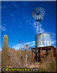
El Camino needs a minimum of two days to travel, and many people take three or more. There are two popular camping areas: at the water bores of Tule Well, and at Papago Well. A scant mile from the Mexican border and mid-way along the trail, these are basic camping areas set on the desert pavement amongst the cacti. We camped at Papago Well, setting up the tent in a clearing where we hoped the cactus spines wouldn't penetrate the tent floor. The Mexican border is a sensitive issue to many Americans. Poorly fenced, in many places it is a sagging single strand of barbed wire. In towns and popular areas it has twenty foot concrete barricades, complete with a permanent armed force and searchlights. Along El Camino, it is barely there, and it is easy for someone to unknowingly stray into Mexico. Or knowingly stray vice versa. States on either side of Arizona - Texas and California - have tightened up on their security, allocating more personnel to patrol the border and apprehend the thousands of border jumpers who each night attempt to cross into the United States to start a new life. The result is that Arizona, long left relatively unprotected, allowing the long stretches of punishing desert to deter the illegal immigrants, is now the hot spot for border crossings. Between 1998 and 1999, apprehensions along El Camino soared from 8000 annually in 1998, to nearly 30,000 in 1999. Most of the people who cross, are individuals, often dropped off just over the border by a "coyote", a smuggler they have paid to get them safely into America. But a small proportion of the illegal traffic is drug smugglers, gun runners and unscrupulous people dealing in bulk human cargo. The sheer numbers of immigrants means that the border patrol's main function has shifted to a search and rescue mission. There are many fatalities each year, as unprepared people die in the desert. As we made camp that night at Papago Well, the border patrol helicopters circled overhead, and in the gathering dusk, the searchlights penetrated to the ground, sweeping over our camp. Around midnight, we were woken by the border patrol hovering over our camp, sweeping the area systematically with their searchlights. Eventually they moved off along the invisible border line, and went to check out a Jeep convoy, which was camped about a mile up the trail. Of course, after being woken so rudely, I, the female Bushduck, needed to pee. Putting on boots and nothing else, I crawled out of the tent and out I went. Only to be circled by the border patrol helicopter with their night vision cameras. I waved into the black of the night. What else is a girl to do? Interestingly enough the male Bushduck safely tucked up inside the tent was just about wetting himself, but with laughter! The next morning we were on the trail early; there had been all too many soft footfalls, close to our tent during the long cool desert night for this relatively remote campsite setting. We meandered through the O'Neill Hills, passing the grave of Dave O'Neill, a prospector who never made the California gold rush. The morning's trail was now a veritable highway of footprints. As we were some sixty miles from civilization as the crow flies, it didn't take much deduction to work out whose footprints they were.
We gave them some, as much as we could spare without running ourselves dangerously short and listened to their story. Our Spanish was rusty, but we understood enough. They had been dropped off by their "coyote" three days earlier, just over the border. He had pointed north and told them that Phoenix was ten miles over the hill. In fact, Phoenix was well over a hundred miles away, with little in between except the arid Sonoran desert. They had had enough. They asked us to call the border patrol to come and collect them. We said we would alert the patrol as soon as we were able and left feeling rather guilty for abandoning people in such a treacherous setting. Naturally, the cell phone didn't work, so it was another six hours of solid desert driving before we arrived in Ajo and alerted the border patrol. But with thousands of people crossing each night, it was likely to be a while before they were picked up.
The final section of the trail passes through the Organ Pipes Cactus National Monument. Organ pipe cactus superficially resembles the organ pipes it is named after, standing up to twenty feet high with thick fleshy stems growing from a single point. The trail passes a pioneer homestead and well, before ending in the small town of Ajo. Ajo is a lot like Broken Hill, Australia. Like many of the copper mines around Broken Hill, the New Cornelia Copper mine is now closed, leaving the huge open pits and terraces standing in bare relief, encircling the town. Ajo has a collection of abode houses, a beautiful Spanish Mission church and, best of all, a good Mexican café and a gas station. Some bean and cheese enchiladas, a couple of cool Coronas, and a fill of unleaded for Drover and the three of us were ready to head north, back into "civilized" Arizona, the Arizona that most people see. To this day, El Camino del Diablo remains one of our most memorable trips into the American backcountry.
Bushducks
© Bushducks 2001
Now available as regional guides for your glovebox:
Be informed when this site is updated: |
 America has deservedly gained a reputation for tough four wheel drive trails. But unlike Australia, which has many truly remote roads where you are unlikely to see another vehicle for days on end, America's Jeep roads tend to be well-traveled.
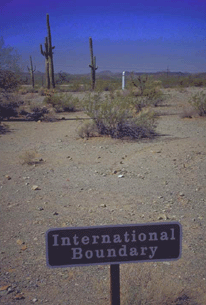 You need three permits to travel the full length of El Camino: a permit to cross the Barry Goldwater
Military Bombing Range, a second one to traverse the Cabeza Prieta National Wildlife Refuge, and a
third to enter the Organ Pipes Cactus National Park. Nowadays the system is streamlined, and one
trip to any one of the three bodies will gain you the required permits. Anyone who signs their life
away to the military, signing their 'Hold Harmless' agreement, that absolves the military of all
responsibility should you be accidentally bombed from above, blown to smithereens by a land mine,
rounded up by land-based maneuvers, or otherwise used as random target practice, can get a permit.
That is, after you have provided three forms of identification, and signed the long and complicated
form in triplicate. You'd think you were applying for an
You need three permits to travel the full length of El Camino: a permit to cross the Barry Goldwater
Military Bombing Range, a second one to traverse the Cabeza Prieta National Wildlife Refuge, and a
third to enter the Organ Pipes Cactus National Park. Nowadays the system is streamlined, and one
trip to any one of the three bodies will gain you the required permits. Anyone who signs their life
away to the military, signing their 'Hold Harmless' agreement, that absolves the military of all
responsibility should you be accidentally bombed from above, blown to smithereens by a land mine,
rounded up by land-based maneuvers, or otherwise used as random target practice, can get a permit.
That is, after you have provided three forms of identification, and signed the long and complicated
form in triplicate. You'd think you were applying for an  We were sitting on the edge the range, well within the recognized limits of the
 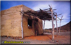 We crossed the Tinajas Altas Range through a narrow pass, choked with debris from the previous wet
season. We picked our way over boulders in the wash, climbing up to the shallow pass to descend down
the far side. The range gets its name from the natural rock tanks, strung like a chain of beads up
a narrow canyon. The Tinajas Altas, which means 'high tanks' in Spanish, were often the last resort of
gold prospectors, missionaries, and fortune seekers making their way west into California. The rock holes
were the first reliable water supply for over fifty miles, and many a poor soul perished at the bottom of
the canyon, too weak from dehydration to tackle the punishing climb up to the tanks and water.
We crossed the Tinajas Altas Range through a narrow pass, choked with debris from the previous wet
season. We picked our way over boulders in the wash, climbing up to the shallow pass to descend down
the far side. The range gets its name from the natural rock tanks, strung like a chain of beads up
a narrow canyon. The Tinajas Altas, which means 'high tanks' in Spanish, were often the last resort of
gold prospectors, missionaries, and fortune seekers making their way west into California. The rock holes
were the first reliable water supply for over fifty miles, and many a poor soul perished at the bottom of
the canyon, too weak from dehydration to tackle the punishing climb up to the tanks and water.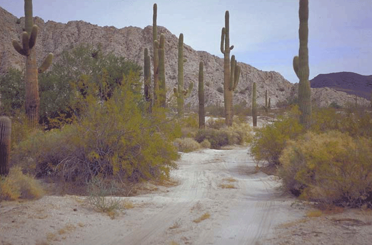 We rounded a corner on the edge of the Organ Pipes National Park to find a group of a dozen young men
stringing themselves in a loose formation across the trail. We stopped and were immediately surrounded
by tired, dusty, and dehydrated people desperately begging in Spanish for water and food.
We rounded a corner on the edge of the Organ Pipes National Park to find a group of a dozen young men
stringing themselves in a loose formation across the trail. We stopped and were immediately surrounded
by tired, dusty, and dehydrated people desperately begging in Spanish for water and food.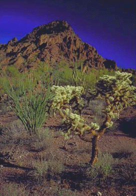 What would happen to them? They would be picked up if found, and taken in a bus back to the Mexican border, dropped off, and as soon as
they had walked over back into Mexico the bus would leave. They are not fined or otherwise penalized;
the sheer numbers make this an impossibility. In case you're wondering why we didn't attempt to transport
these lost people to safety, as one would do in outback Australia, border authorities here have
officially advised us against doing so. Car jackings have been reported, although they are very
infrequent. And the sheer numbers of people make it impossible to transport them all. The official
position is you are encouraged to offer food and water, but not to give anyone a lift unless it is
life threatening. And as soon as possible, alert the Border Patrol.
What would happen to them? They would be picked up if found, and taken in a bus back to the Mexican border, dropped off, and as soon as
they had walked over back into Mexico the bus would leave. They are not fined or otherwise penalized;
the sheer numbers make this an impossibility. In case you're wondering why we didn't attempt to transport
these lost people to safety, as one would do in outback Australia, border authorities here have
officially advised us against doing so. Car jackings have been reported, although they are very
infrequent. And the sheer numbers of people make it impossible to transport them all. The official
position is you are encouraged to offer food and water, but not to give anyone a lift unless it is
life threatening. And as soon as possible, alert the Border Patrol. Back Country Adventures: Arizona
 Arizona Trails Central Region
 Arizona Trails West Region
 Arizona Trails Northeast Region
 Arizona Trails South Region